Луизиана мужийн өмнөд хэсэгт хүрсэн Берта шуурганы улмаас АНУ-ын Галф эргийн дагуух бүс нутгуудад аюулгүй байдлын арга хэмжээ авч, эрэг орчмын үйл ажиллагааг зогсоолоо.
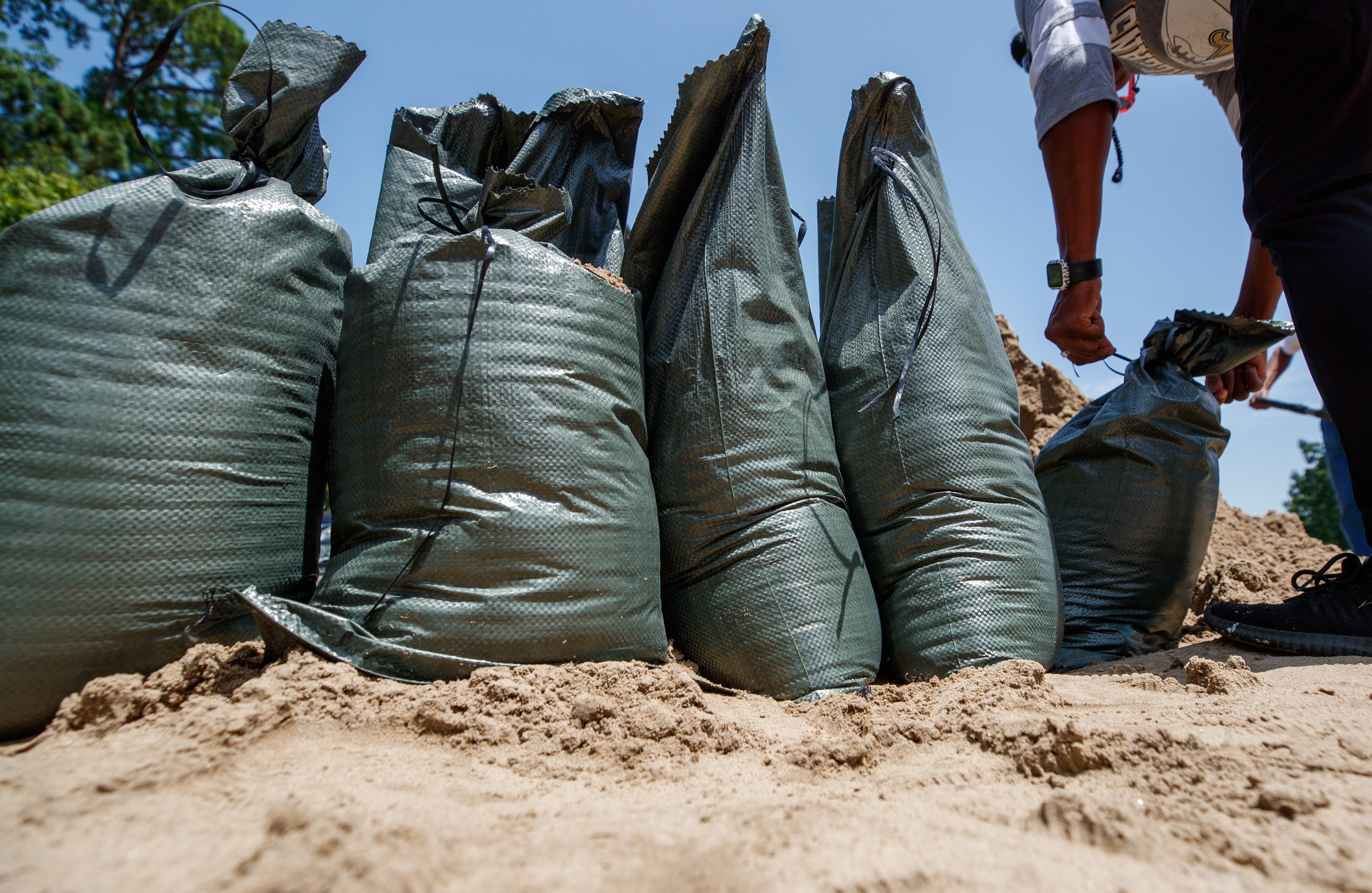
Майамид байрлах Үндэсний хар салхины төвөөс мэдээлснээр, Берта шуурга Лхагва гарагт Луизиана мужийн Сент-Бернард дүүрэгт хүрсэн байна. Шуурганы төвөөс 160 километрийн зайд хүчтэй салхи салхилж байгаа бөгөөд Алабама, Флорида мужийн хилээс Луизиана хүртэлх бүс нутагт халуун орны шуурганы сэрэмжлүүлэг зарлажээ. Орон нутгийн эрх баригчид эрэг орчмын парк, гүүрүүдийг хааж, оршин суугчдад элсээр дүүргэсэн шуудайнуудыг тарааж эхэлсэн байна.
Шуурганы улмаас далайн түвшин нэг метр хүртэл нэмэгдэж, зарим бүс нутагт 5-10 сантиметр хүртэл аадар бороо орох төлөвтэй байна. Берта нь Атлантын далайн хар салхины улирлын хоёр дахь шуурга бөгөөд өмнө нь Артур шуурганы улмаас үерт нэрвэгдсэн Миссисипи мужийн эргийн бүсүүдэд дахин эрсдэл учруулж болзошгүй байгаа юм.
АНУ-ын бусад хэсэгт ч мөн цаг агаарын таагүй байдал үргэлжилж байна. Цинциннатигаас Нью-Жерси хүртэлх бүс нутагт хар салхи дэгдсэн бол Баруун Виржиниа мужид аадар борооны улмаас гэнэтийн үер бууж, гүүрүүд эвдэрч, орон сууцнууд усанд автсаны улмаас аврах ажиллагаа явуулжээ.
Үүний зэрэгцээ Номхон далайн зүүн хэсэгт Фаусто хар салхи үүсээд байгаа боловч эх газраас хол, Баха Калифорнийн өмнөд үзүүрээс баруун-баруун өмнө зүгт төвлөрч байна. Цаг уурчид Фаустогийн нөлөөгөөр далайн давалгаа ихсэж, эрэг орчмын бүсэд аюултай урсгал үүсэж болзошгүйг анхаарууллаа.
Дэлгэрэнгүйг эх сурвалжаас харах
↓Эх сурвалжийг нээх ↓
Tropical Storm Bertha made landfall on the southern tip of Louisiana Wednesday, packing strong winds far from its center after forcing the closure of beaches from the Florida Panhandle to Mississippi.
Bertha touched down in St. Bernard Parish, about 40 miles (65 kilometers) east of New Orleans and 45 miles (72 kilometers) southwest of Biloxi, Mississippi, the Miami-based National Hurricane Center said.
The wind and storm surge were the main threats for the Deep South states. Parks and piers were closed up and down the coast, as were some low-lying roads.
A tropical storm warning stretched from the Alabama-Florida border over to Louisiana, including metropolitan New Orleans and Lake Pontchartrain, National Hurricane Center said.
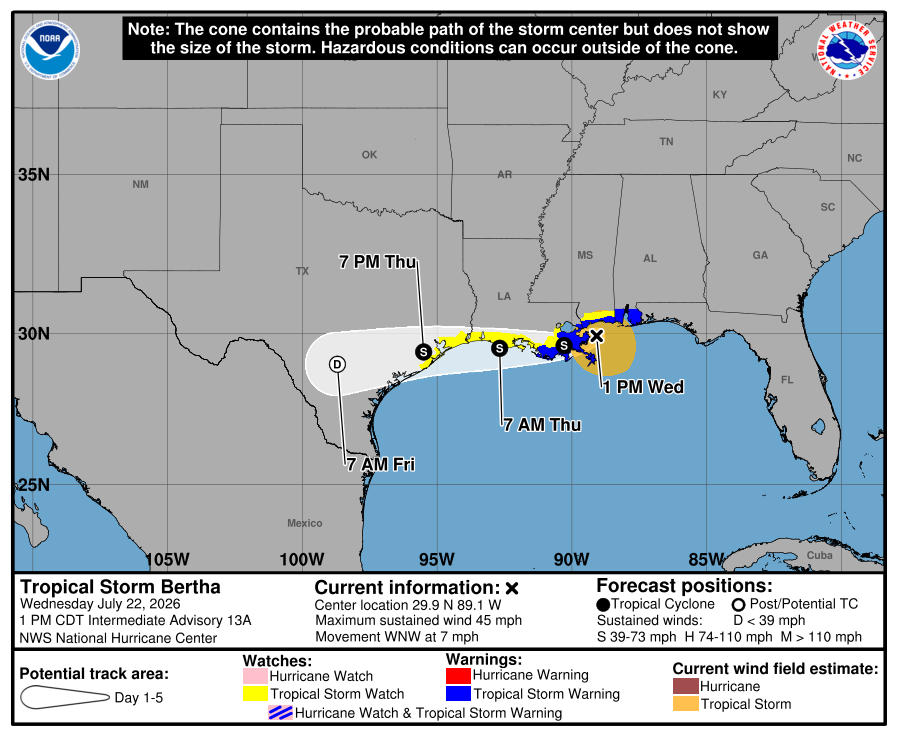
Tropical storm force winds extend over 100 miles (160 kilometers) out from the center of Bertha. Storm surge up to 3 feet (1 meter) is possible in Louisiana as well as heavy rain in some areas, forecasters said. Rain totals were forecast between 2 to 4 inches (5 to 10 centimeters), with higher amounts possible in isolated areas.
Bertha is expected to continue losing strength over the next few days as it heads toward Texas after the storm earlier trudged past the Florida Panhandle and the tips of Alabama and Mississippi. At landfall, the storm’s maximum sustained winds were around 45 mph.
Elsewhere in the U.S. this week, a line of storms generated reports of tornadoes stretching from Cincinnati to New Jersey. Torrential rains caused flash floods Tuesday night that swamped homes, washed out bridges and led to water rescues in West Virginia, authorities said.
Sandbag distribution sites are set up
Authorities in Mississippi, Louisiana and Florida opened sites to provide sandbags to residents who may be impacted by Tropical Storm Bertha. Double-red flag warnings were posted along some beaches, closing them to swimmers.

“For locals, this is just another storm,” said Candice Henderson, manager of the Crab Trap, a beachside restaurant that was packed Tuesday on Pensacola, Florida’s Perdido Key. “When you’re on vacation and it’s raining, you either shop or you go out to eat.”
Bertha is the second tropical storm of the Atlantic hurricane season. Tropical Storm Arthur in June brought heavy rainfall to the southeastern U.S.
Bertha could dump heavy rain on coastal areas of Mississippi that are still recovering from flooding brought by Arthur that destroyed and damaged homes.
Hurricane Fausto in the Pacific is far from land
In the eastern Pacific Ocean, Hurricane Fausto churned far from land Wednesday. The hurricane was hundreds of miles west-southwest of the southern tip of Baja California with maximum sustained winds of 80 mph (130 kph).
It was forecast to gradually strengthen and the hurricane center warned that ocean swells generated by Fausto could cause life-threatening surf and rip tide conditions on the Baja California coast.