Google Maps газрын зураг ашиглан хийсэн судалгаагаар Квебек мужийн нутгаас солирын уналтын ул мөр болох 25 км-ийн өргөнтэй тогоог олж илрүүлжээ.
Сонирхогч одон орон судлаач Жоэль Лапуант 2024 онд аялал төлөвлөх явцдаа Квебекийн хойд хэсэгт байрлах Марсал нуурын орчимд дугуй хэлбэрийн хотгор газрыг анзаарсан байна. Энэхүү байршлыг гариг судлаачдад мэдэгдсэний дагуу Вестерний их сургуулийн профессор Гордон Осински тэргүүтэй баг 2025 онд газар дээр нь очиж судалгаа хийжээ. Судлаачид тус бүс нутагт амьдардаг Инну омгийнхонтой зөвшилцсөний үндсэн дээр уг тогтоцыг “Ухакатикийн тогоо” хэмээн нэрлэсэн байна.
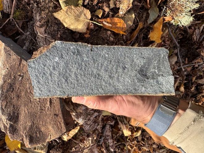
Шинжилгээгээр тус тогоо нь Девоны галавын үед буюу ойролцоогоор 390 сая жилийн өмнө солир унасны улмаас үүссэнийг тогтоожээ. Судлаачид газар дээр нь ажиллах явцдаа мөргөлдөөний улмаас үүссэн халуун хайлмал чулуулаг болон цохилтын долгионоор үүсдэг “хагарлын конус” хэлбэрийн чулуулгийн хэлтэрхийг илрүүлсэн нь солирын тогоо болохыг батлах гол нотолгоо болсон юм.
Сансрын зураглалын технологи нь дэлхийн гадаргуу дээрх нууцлаг тогтоцуудыг илрүүлэхэд чухал үүрэг гүйцэтгэж байна. Тухайлбал, Гранд Каньон орчмын ургамлын бүрхэвчийн ер бусын тойрог хэлбэрийн хээг физикч Амелиа Каролина Спаравигна судалж, үүнийг улаан хортон шоргоолжны үүр болон тэдгээрийн орчны ургамлын харилцан үйлчлэлтэй холбоотой байж болзошгүй гэсэн таамаг дэвшүүлжээ. Эдгээр ололт нь хиймэл дагуулын өгөгдөл нь геологийн болон биологийн судалгаанд хэрхэн тус нэмэр болдгийг харуулж байна.
Дэлгэрэнгүйг эх сурвалжаас харах
↓Эх сурвалжийг нээх ↓
A circular formation surrounding Lake Marsal in northeastern Quebec first appeared on Joël Lapointe’s computer screen while he was planning a camping trip in 2024. The amateur astronomer was studying the Côte-Nord region on Google Maps when he noticed a ring-shaped depression about 25 kilometers wide.
Lapointe shared the location with planetary geologists, who later traveled into the remote landscape to examine its rocks. Their field observations and laboratory work dated the formation to approximately 390 million years ago and linked it to a meteorite collision. The structure has been named the Uhакkatik crater in consultation with the Innu Council of Ekuanitshit.
The Quebec finding is one of several large natural features first recognized or closely examined through satellite mapping. Similar searches have located a vast limestone bridge in China and unusual circles in vegetation near the Grand Canyon.
A Circular Feature Led Geologists Into Northern Quebec
Gordon Osinski, a planetary geology professor at Western University, regularly receives reports of possible impact sites through his Impact Earth project. Many circular formations have ordinary geological origins, including erosion, glaciers and volcanic activity. The Lake Marsal structure appeared distinctive enough to justify a field investigation.
In 2025, Osinski and his team spent five days examining the site. Dense vegetation prevented their float plane from reaching the shore, so the researchers carried their equipment through more than 160 feet of water. They photographed exposed cliffs and collected samples for analysis in laboratories in Canada and France.
The formation lies within the traditional territory of the Innu of Ekuanitshit. Its name was selected through consultation with the community’s council, connecting the geological designation to the land where the structure is located.
Shatter Cones Record the Force of the Collision
The shape seen on Google Maps guided scientists to the site, but the evidence came from the rocks. Some cliffs contained material that appeared to be impact melt rock, which forms when the intense heat of a collision melts part of the surrounding ground.
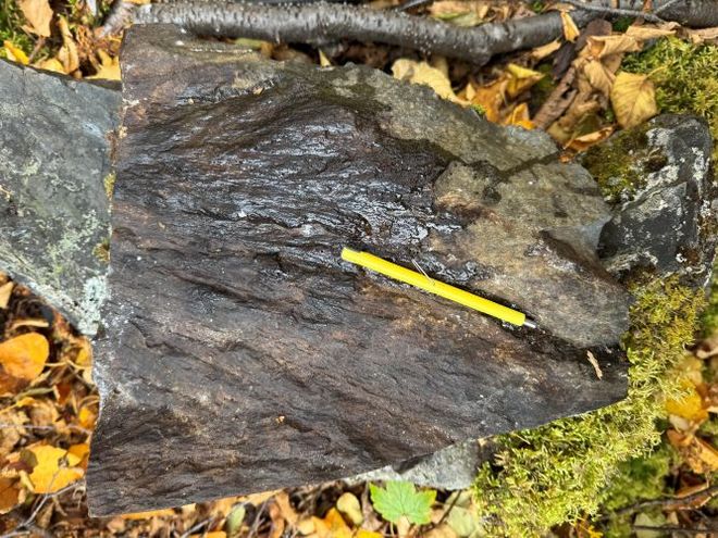
On the second day of the expedition, the team found shatter cones. These cone-shaped fractures develop when powerful shock waves travel through solid rock. They are associated mainly with meteorite impacts and underground nuclear explosions, making them an important marker for identifying an impact structure.
Laboratory analysis of rocks formed during the collision produced the 390-million-year age estimate. The event occurred during the Devonian Period, hundreds of millions of years before the appearance of dinosaurs. The crater would join a global catalog of roughly 200 impact structures identified through geological evidence.
Satellite Images Expose Patterns Hidden From the Ground
Google Earth has also revealed unusual vegetation near Vulcan’s Throne, a volcanic cinder cone on the Grand Canyon’s North Rim. Physicist Amelia Carolina Sparavigna noticed large barren circles scattered through desert plants and proposed that colonies of red harvester ants (Pogonomyrmex barbatus) produced the pattern.
These ants remove vegetation around their nests. Sparavigna reported that their mounds can reach about 47 inches across, with roughly 108 square feet of bare ground surrounding each one. Thousands of similarly cleared areas could create the polka-dot appearance visible in satellite images.
Sparavigna described the proposed mechanism carefully: “It is quite probable that the observed patterned vegetation can have its origin from the interaction of vegetation and ants.” She added that an on-site investigation was needed to determine the cause.
References:
- CBC:He saw a pit on Google Maps. It turned out to be a 390-million-year-old meteor crater
- Green Matters:Physicist Finally Solves the Mystery Behind Strange Polka-Dot Patterns Found in the Grand Canyon
- Natural Arches:Fairy Bridge
Enjoyed this article? Subscribe to our free newsletter for engaging stories, exclusive content, and the latest news.

