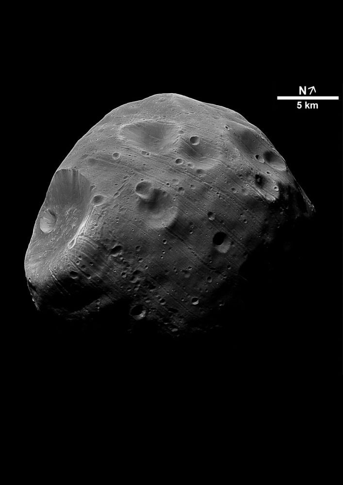
Европын судлаачид Фобос сарны гадаргын динамик шинжийг харуулсан шинэ атлас бүтээснээр JAXA-ийн ирээдүйн сансрын миссийн дээж цуглуулах талбайг оновчтой сонгох боломж бүрдлээ.
Японы сансрын агентлаг (JAXA)-ийн Martian Moons eXploration (MMX) мисс нь аравдугаар сард хөөрч, 2027 онд Ангараг гаргийн хамгийн том дагуул Фобос дээр хүрэхээр төлөвлөж байна. Энэхүү миссийн зорилго нь 2031 онд тус сарнаас дээж авч Дэлхий рүү авчрах явдал юм. Дээж цуглуулах үйл ажиллагааны нарийвчлалыг хангахын тулд судлаачид Фобосын гадаргын бүтцийг гүнзгий ойлгох шаардлагатай байгаа аж.
Испанийн Астробиологийн төвийн Изабел Эррерос болон Парисын Дэлхийн физикийн хүрээлэнгийн Себастьян Шарно нар Фобосын гадаргын морфодинамик атласыг бүтээжээ. Тэд дижитал газрын загвар (DTM) ашиглан Фобосын гадаргын хэлбэр, түүний дотор хагарал, хөрсний гулсалт болон Стикни тогооны бүтэц зэргийг нарийвчлан судалсан байна. Фобос нь Ангарагийн таталцал, эргэлт болон бусад хүчний нөлөөгөөр байнга өөрчлөгддөг динамик орчинтой тул энэхүү судалгаа нь чухал ач холбогдолтой юм.
Судлаачид “Реголит шилжилтийн зам” (RMPs) хэмээх нэр томьёог нэвтрүүлж, гадаргын материал хэрхэн шилжиж, хуримтлагддагийг загварчилжээ. Энэхүү загвар нь MMX миссийн дээж авах хоёр гол цэгийн түүхийг ялгаж өгч байна. Ангарагтай ойр цэг дээр удаан хугацаанд хуримтлагдсан, сансрын цаг уурын нөлөөнд орсон хуучин реголит байх төлөвтэй бол, Ангарагаас алслагдсан цэг дээр илүү шинэ, хөндөгдөөгүй материал байх магадлалтай юм.
Гэсэн хэдий ч уг загвар нь Фобосын либраци буюу чичиргээний нөлөө болон гадаргын материалын механик шинж чанарыг бүрэн тооцоолоогүй гэдгээрээ хязгаарлалттай. Энэхүү атлас нь ирээдүйн дээжүүдийг геологийн болон тээвэрлэлтийн нөхцөл байдалтай нь уялдуулан тайлбарлахад чиглэсэн арга зүйн суурь болох юм.
Дэлгэрэнгүйг эх сурвалжаас харах
Эх сурвалжийг нээх ↓
Thanks to JAXA, the Japan Aerospace Exploration Agency, and their sample-return prowess, we’re on the cusp of our first sample from the Martian system. Not from Mars itself, but from its largest moon Phobos. JAXA’s Martian Moons eXploration (MMX) mission is set to launch in October. It will reach Phobos in 2027, and, if successful, return a sample from the moon to Earth in 2031.
A lot of advance work goes into a sample return mission. Scientists need a solid understanding of the object they’re sampling to provide context for their samples. To many of us, one rock looks much like the next. But to a scientist, even a few grams of regolith is loaded with information. And decoding that information to its fullest extent can depend on context.
Two European researchers have created an atlas of Phobos’ surface that will help scientists understand MMX’s sample gathering activities. They present it in a research letter titled “The dynamical surface of Phobos: A morphodynamic atlas,” published in Earth and Planetary Science Letters. The authors are Isabel Herreros from the Spanish Astrobiology Center in Madrid, and Sébastien Charnoz from the Institut de Physique du Globe de Paris.
Despite being a fairly small chunk of rock only about 11 km in diameter, Phobos has an interesting history, one we’re uncertain about. It may be a rubble pile asteroid with a thin crust that’s slowly being torn apart by tidal interactions with Mars. It’s similar to some asteroids, meaning it may be a captured asteroid. Or it could be a disk-derived moon that coalesced out of material thrown into orbit around Mars, following an impact between Mars and another body. It could even be the result of some sort of hybrid process.
Its confusing origins speak to the dynamic environment it’s situated in.
“Phobos evolves in a highly dynamical environment where surface-material motion is controlled by the combined effects of self-gravity, time-dependent Martian tides, and inertial forces,” the authors write. “In such a low-gravity regime, the displacement of loose material, like regolith, cannot be inferred from topographic slope alone, making a dynamical approach essential for interpreting Phobos’ surface morphology and for supporting the Martian Moons eXploration (MMX) mission led by JAXA.”
What they’re saying is that rocks don’t just slide downhill on Phobos like they do on Earth. Earth’s own gravity dominates that process, and tidal considerations are irrelevant. On Phobos, things are much different, and the researchers created their atlas to illustrate material flow.
To create their morphodynamic atlas, the researchers started with a digital terrain model (DTM) of Phobos. The DTM captured all of the moon’s surface features, including grooves, lineaments, and landslides. It also included terrain with sparse impact craters, the dominating Stickney Crater, and different spectral units.
There’s plenty of evidence of surface material moving around on Phobos’ surface, and on such a small body, gravity isn’t the only force behind the movement. “In Phobos’ low-gravity environment, stability and mobility of surface material are controlled not only by local topography but also by orbital and rotational forces (centrifugal, tidal, and Coriolis),” the authors write.
The researchers mapped out the acceleration vectors on Phobos’ surface, and in turn, those maps identified dynamical features where vectors were organized in specific ways.
These panels make up a surface acceleration map of Phobos. The colours show the local dynamical slope, and the legend on the right shows slope degree. The map also shows the most prominent dynamic features, labelled a through i. Image Credit: Herreros & Charnoz 2026. EPSL.
These acceleration maps and dynamical features were just the beginning. They “provide information only about the direction of the local acceleration with respect to the local topography,” the authors explain. This is only a simple look at regolith movement on Phobos’s surface. They had to dig deeper, and include both centrifugal and tidal forces.
Other research has examined the surface and identified zones of instability on Phobos and where material is likely to be dislodged from. But none has determined where this moving material is likely to end up at. Since MMX is only gathering about 10 grams of material, the material is likely to have flowed across the surface in the past. By including gravity, rotation, and gravitational tides, the atlas will show how this has happened.
“To understand how regolith is redistributed across Phobos’ surface, it is therefore necessary to model the dynamical motion of surface material under the combined action of gravity, tides, rotation, and also friction,” the researchers explain. Friction angles, both static and dynamic, combine to determine how easily material starts moving, and how far it travels before it comes to a stop.
The authors used their DTM of Phobos and their own code to model how material moves around on the moon’s surface. The model’s job wasn’t to identify unstable regions where material is likely to be dislodged. Instead, it identified regolith migration pathways.
The model reveals “… large-scale coherent dynamical regions and a sparse network of preferred regolith transport routes, termed here Regolith Migration Pathways (RMPs),” the authors write.
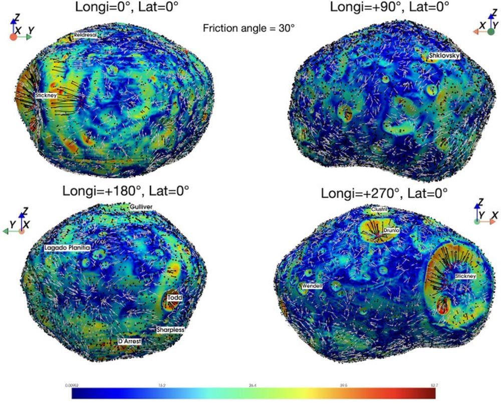
These panels show surface trajectories projected onto a global map of Phobos. “Black lines highlight the Regolith Migration Pathways (RMPs), defined as preferred routes of regolith transport under the combined effects of self-gravity, centrifugal, and tidal accelerations,” the authors explain. Image Credit: Herreros & Charnoz 2026. EPSL.
The terminations of the RMPs correlate with low-relief terrains that are spectrally neutral and smooth. That’s consistent with an area that’s been filling in with regolith over the long term, forming a depositional mantle.
Areas above those, with rougher terrain, lots of smaller craters, and “blue spectral slopes,” are active regions, or regions that have already lost loose regolith. Red spectral terrain is different. These are rough surfaces that don’t see much regolith movement. These regions are older and their surfaces aren’t subject to so much change.
“Taken together, these patterns indicate that much of Phobos’ surface morphology and spectral heterogeneity can be explained by long-term regolith redistribution driven by the surface acceleration field along RMPs,” the researchers explain.
A quick look at the above figure, without much deeper analysis, shows that RMPs run along major craters.
“Under this stringent assumption (meaning the 30 degree friction angle), we find that: (i) downslope transport is limited to the interior of the major craters, and also along the eastern outer slope of Stickney crater; (ii) no significant transport is found in most of the dynamical features,” the authors write.
The researchers also worked with a 14 degree friction angle, which they say “is not intended to represent present-day spontaneous motion,” yet presents large scale RMPs that may have operated in the past.
Concerning the models with different angles, the authors write “Together, these pathways delineate dynamically active regions where long-term regolith motion can contribute to surface reshaping, crater infilling, and the development of spectral and morphological heterogeneity.”
What it boils down to is understanding MMX’s sample collection sites. MMX will take two samples from key regions on Phobos; one near the sub-Mars point and one near the anti-Mars point. This work shows that they’re “distinct surface environments with contrasting regolith histories.”
At the sub-Mars site, material from Stickney crater’s eastern outer slope and nearby terrain accumulates. That material should consist of aged and well-mixed regolith that comes from multiple sources. It will have been exposed to space weather for a long time and will be aged.
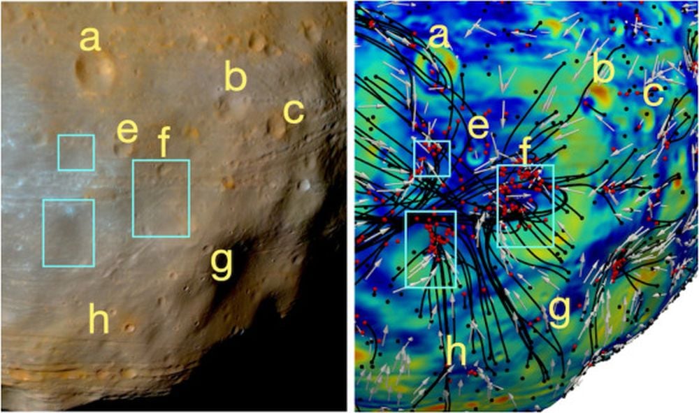 This is a close-up of the sub-Mars point. The letters are topographic features used as control points. The blue boxes are regions where regolith is expected to accumulate. In the image on the right, black lines mark RMPs and red dots mark their endpoints. Image Credit: Herreros & Charnoz 2026. EPSL.
At the anti-Mars point, there’s more activity and the regolith may still be moving. “Samples from this area may thus include younger, less-weathered material, potentially preserving information about Phobos’ more pristine surface or shallow subsurface,” the authors explain.
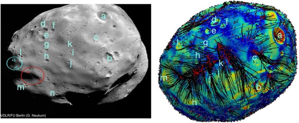 These panels show the anti-Mars point on Phobos. As above, letters are topographic control points. It’s dense with RMPs that converge along a band near the equator, and red culmination points also cluster there. Regolith movement here is likely much more recent. Image Credit: Herreros & Charnoz 2026. EPSL.
Though thorough, the authors point out that there are some necessary simplifications in their model. For example, it doesn’t include the effect of Phobos’ libration. The model also makes no assumptions about “the internal structure of the surficial material, its rheological behaviour, or its detailed mechanical properties.” That includes how likely individual pebbles are to stick together, and other fine-grained details.
“Overall, this work establishes a methodological framework for interpreting surface transport on Phobos and for placing future MMX samples within their broader geomorphological and transport context,” the authors conclude.

