Голын гүн суусан нугалаа Колорадогийн өндөрлөг өргөгдөж, урсгалын элэгдэл нэмэгдсэнтэй холбоотой байж болох ч энэ геологийн үйл явцын түүх бүрэн тайлагдаагүй.
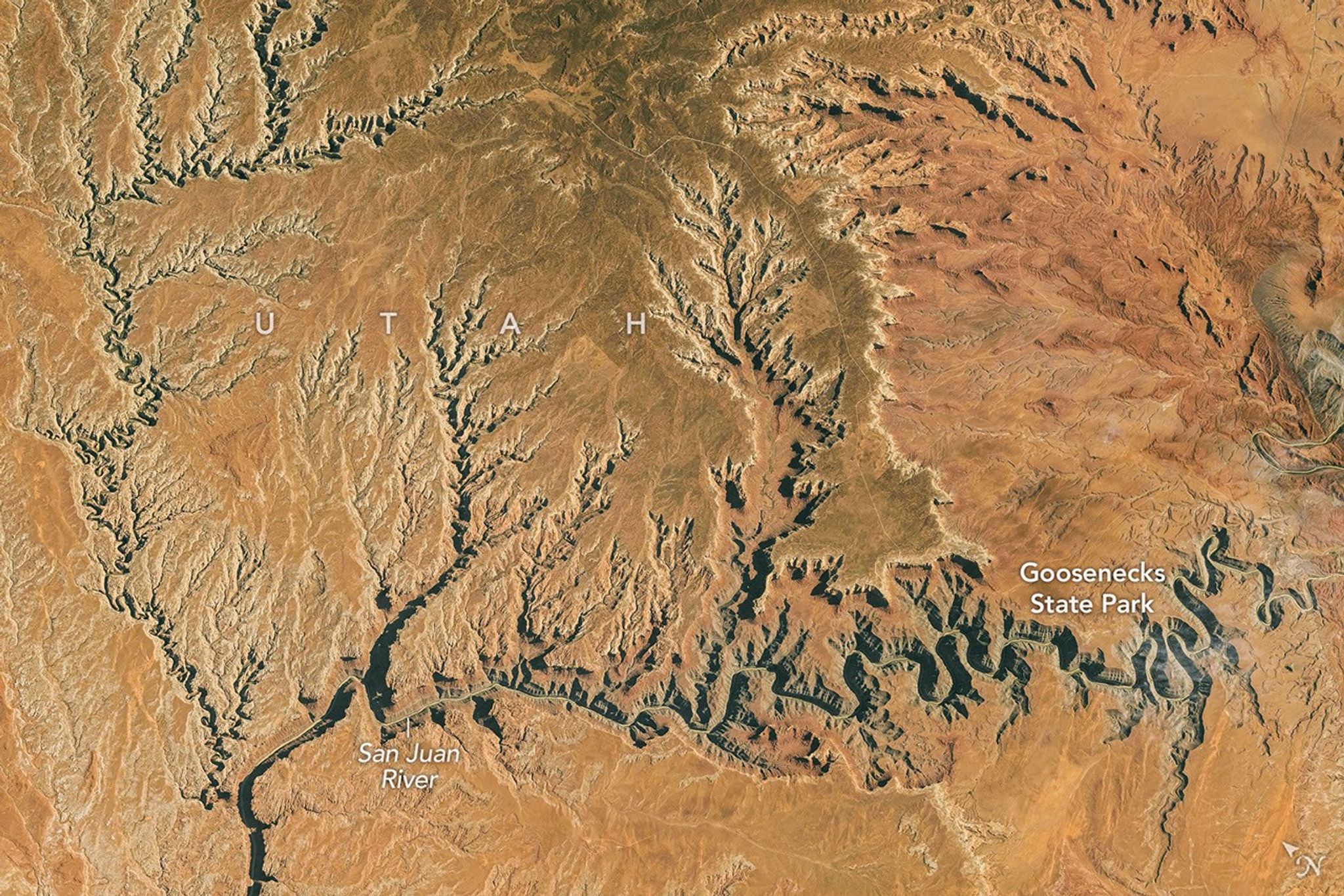
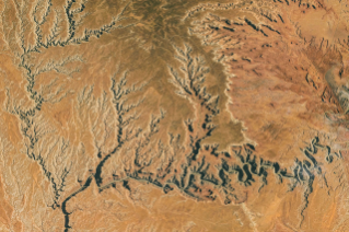
Олон улсын сансрын станцад ажиллаж байсан Expedition 75 багийн гишүүн Ютагийн өмнөд хэсгийн Сан-Хуан голын хавцлыг 2026 оны аравдугаар сарын 6-нд гэрэл зурагт буулгажээ. Зургийг Nikon Z9 камераар, 400 мм-ийн фокусын урттай авч, тодосгогчийг сайжруулахын тулд тайрч боловсруулан, линзний гажгийг арилгасан байна.
Хэдэн арван сая жилийн өмнө гол эртний далайн орчинд тогтсон харьцангуй тэгш тал дээгүүр аажуухан тахирлан урсдаг байжээ. Зарим мэргэжилтний үзэж буйгаар, ойролцоогоор 20 сая жилийн өмнөөс өргөгдөж эхэлсэн Колорадогийн өндөрлөгийн хожуу үеийн өргөлт голын эхийг өндөрт хүргэж, урсгалын налуу болон хурдыг нэмэгдүүлсэн байна. Ингэснээр элэгдүүлэх хүч нь нэмэгдэж, гол 300 сая жилийн настай чулуулгийг гүн зүссээр өнөөгийн нугалаат хавцлыг бий болгосон байж болзошгүй.
Гол одоо Пауэлл нуур руу баруун тийш урсах замдаа “галууны хүзүү” хэмээн нэрлэдэг гүн суусан тахир нугалаануудыг дайрна. Goosenecks State Park дахь хавцал 300 метр орчим гүн бөгөөд нэг хэсэгт голын урт 8.9 км хүрэх ч шулуун зай нь ердөө 2.1 км байдаг. Тус парк 2021 онд Олон улсын харанхуй тэнгэрийн паркаар бүртгэгдсэн бөгөөд энд Персейн давхар бөөгнөрөл, Сүүн замын Нумын салаан дахь Мессье 24 оддын үүл нүдэнд үзэгддэг; 2026 оны арваннэгдүгээр сард Тауридын хойд, өмнөд урсгал болон Леонидын солирын борооны оргил үе тохионо.
Дэлгэрэнгүйг эх сурвалжаас харах
Эх сурвалжийг нээх ↓
Tens of millions of years ago, the San Juan River in what is now southern Utah shared some characteristics with today’s Mississippi River. In a bygone geologic era, the San Juan flowed across a relatively flat plain that formed in an ancient marine environment. Unencumbered by rugged terrain, the river was free to take a long, meandering path on its gradual journey downslope.
But this part of the San Juan changed when geologic forces pushed the Colorado Plateau upward. Some experts think that within the later stages of this “still-enigmatic” history, starting around 20 million years ago, the plateau’s rise elevated the San Juan’s headwaters, which increased the river’s gradient and sped its flow. With that, the water’s erosive power intensified, and the river started carving its winding path deeper and deeper through 300-million-year-old rock.
Today, on its westward path to Lake Powell, the San Juan River flows through an impressive series of entrenched meanders, also known as “goosenecks.” An astronaut aboard the International Space Station photographed the stark desert topography on October 6, 2026.
In Utah’s Goosenecks State Park, the river runs through a canyon 1,000 feet (300 meters) deep. In places, it nearly loops back on itself, making horseshoe-shaped bends. One section is so curvy that the river travels 5.5 miles (8.9 kilometers) between two points that are only 1.3 miles (2.1 kilometers) apart as the crow—nay, goose—flies.
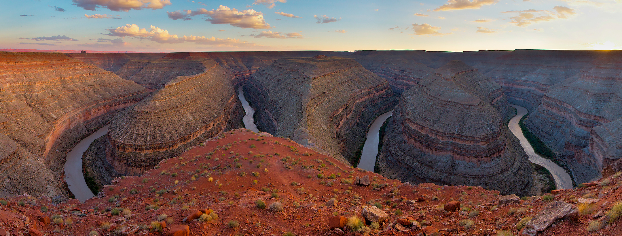
While the goosenecks are an unusual geologic wonder to behold by day, the area’s dark skies are a spectacle by night. Goosenecks State Park’s remote, high-desert location and 360-degree views of the sky helped earn it an International Dark Sky Park designation in 2021. According to DarkSky International, features such as the Double Cluster in Perseus and the Messier 24 star cloud in the Sagittarius spiral arm of the Milky Way are visible to the unaided eye from the park. In November 2026, dark skies offer the chance to view several meteor showers, with the Northern Taurids, Southern Taurids, and Leonids reaching their peaks throughout the month.
Astronaut photographISS075-E-188830was acquired on October 6, 2026, with a Nikon Z9 digital camera using a focal length of 400 millimeters. It is provided by the ISS Crew Earth Observations Facility and the Earth Science and Remote Sensing Unit at NASA Johnson Space Center. The image was taken by a member of theExpedition 75crew. The image has been cropped and enhanced to improve contrast, and lens artifacts have been removed. TheInternational Space Station Programsupports the laboratory as part of theISS National Labto help astronauts take pictures of Earth that will be of the greatest value to scientists and the public, and to make those images freely available on the internet. Additional images taken by astronauts and cosmonauts can be viewed at the NASA/JSCGateway to Astronaut Photography of Earth. Photo by Bob Wick (BLM), via Flickr. Story by Lindsey Doermann.
References & Resources
- DarkSky International (2021, March 25) Goosenecks State Park. Accessed November 5, 2026.
- Karlstrom, K.E., et al. (2022) Tectonics of the Colorado Plateau and Its Margins. Annual Review of Earth and Planetary Sciences, 50:295-322.
- NASA Earth Observatory (2020, July 19) Meandering Mississippi River. Accessed November 5, 2026.
- Utah Geological Survey (2013, September) GeoSights: The Goosenecks of the San Juan River, San Juan County, Utah. Accessed November 5, 2026.
- Utah State Parks, Goosenecks State Park. Accessed November 5, 2026.
You may also be interested in:
Stay up-to-date with the latest content from NASA as we explore the universe and discover more about our home planet.