Европын сансрын агентлагийн (ESA) тойрог замын станцууд Ангараг гарагийн өмнөд туйлын бүсэд олон зуун хар өнгийн, аалз мэт хэлбэртэй тогтоцууд байгааг илрүүлжээ.
Эдгээр тогтоц нь амьд биет бус, харин улирлын чанартай явагддаг геологийн үзэгдэл юм. Ангараг гарагийн хаврын улиралд нарны гэрэл мөсөн давхаргыг нэвтлэн доорх хөрсний гадаргууг халаадаг. Үүний улмаас нүүрстөрөгчийн давхар исэл хатуу төлөвөөс шууд хий болон хувирч, мөсөн дор даралт үүсгэдэг байна. Даралт нэмэгдэхийн хэрээр хий нь мөсөн давхаргыг хагалан оргилж, улмаар хар өнгийн тоосонцрыг гадаргуу дээр цацдаг аж. Энэхүү хийн урсгал нь мөсөн доогуур салаалсан сувгуудыг ухаж гаргадаг бөгөөд 45 метр хүртэлх өргөнтэй эдгээр суваг нь дээрээс харахад аалзны хөлтэй төстэй дүрс үүсгэдэг байна.
Mars Express болон ExoMars Trace Gas Orbiter сансрын хөлгүүдийн авсан өндөр нарийвчлалтай зураглалаар энэхүү үзэгдлийг бүрэн тайлбарлажээ. Mars Express хөлөг нь дэлбэрэлтийн дараах хар өнгийн тоосонцрын тархалтыг бүртгэсэн бол Trace Gas Orbiter хөлөг мөсөн доорх нарийн сувгуудыг илүү тодорхой дүрсэлсэн байна.
Эдгээр тогтоц нь “Инкийн хот” хэмээн нэрлэгддэг Angustus Labyrinthus бүсэд илүү нягт байрладаг. Энэхүү 86 км-ийн голчтой, шулуун хэрмүүд бүхий бүс нь сансрын биет мөргөсний улмаас үүссэн тогоо байж болзошгүй гэж эрдэмтэд таамаглаж байна. Мөн тус бүсэд салхи болон мөсний элэгдлийн улмаас 1500 метрээс өндөр хавтгай оройтой уулс, шороон овоолгууд үүссэн нь Ангараг гарагийн гадаргуугийн хувьслыг судлах чухал мэдээлэл болж байна.
Дэлгэрэнгүйг эх сурвалжаас харах
↓Эх сурвалжийг нээх ↓
Hundreds of dark formations resembling spiders cover parts of Mars’ southern polar region, including a landscape known as Inca City. Images from the European Space Agency’s Mars Express orbiter show the markings scattered across plateaus, hills and the edges of a network of ridges near the planet’s south pole.
The features are not animals. They form each Martian spring when sunlight warms seasonal layers of carbon dioxide ice from below. Gas builds beneath the frozen surface, breaks through the overlying slab and carries dark material onto the ice, leaving spots between 45 meters and 1 kilometer wide.
Beneath those spots, escaping gas cuts branching channels into the ice. Their thin, radiating grooves create the spider-like shape seen in high-resolution orbital images, giving the seasonal formations their informal name.
Spring Sunlight Releases Gas Beneath the Ice
During the dark Martian winter, carbon dioxide from the atmosphere freezes onto the ground near the poles. When sunlight returns in spring, it passes through the translucent ice and warms the base of the frozen layer, where the ice touches the darker ground.
The heated carbon dioxide undergoes sublimation, a process in which a solid changes directly into gas without becoming liquid. Because the gas is trapped beneath the remaining ice, pressure increases until cracks open through slabs that can reach one meter in thickness.
Gas and dust then rush through the openings. The European Space Agency’s report of the Mars spiders describes these eruptions as “tall fountains or geysers.” The dark material rises through the cracks before falling back and spreading across the bright frozen surface.
As the pressurized gas travels beneath the ice, it follows multiple paths toward the opening. Those flows carve the branching channels that appear like legs extending from a central point. The channels remain below the seasonal ice, while the expelled dust forms the dark patches visible above them.
Orbital Images Show Two Parts of the Same Process
The Mars Express spacecraft photographed the broad landscape and the dark surface deposits created by the eruptions. Its High Resolution Stereo Camera records the terrain from different angles, allowing scientists to study the shapes and elevations of the surrounding ridges, plateaus and hills.
A second ESA spacecraft, the ExoMars Trace Gas Orbiter, captured the underlying tendril-shaped channels in greater detail. The spiders photographed by that orbiter lie close to, but outside, the area shown in the newer Mars Express view.
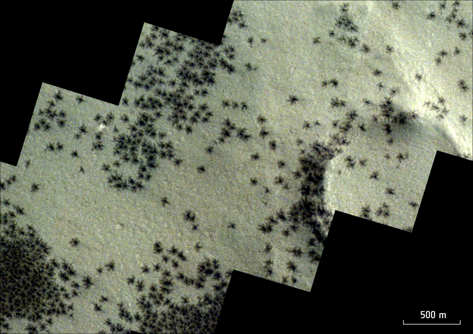
Together, the images show how the dark spots and the channels develop from one seasonal event. Mars Express records the dust deposited after gas escapes, while the Trace Gas Orbiter shows the web-like grooves cut beneath the ice.
The formations repeatedly appear as the southern polar ice warms during the Martian spring. Their distribution across the surface reflects where gas pressure builds beneath the seasonal ice and finds a path through cracks.
Mars Spiders Gather Around Inca City
Many of the dark markings appear near Inca City, an area formally called Angustus Labyrinthus. The region received its nickname because its straight, intersecting ridges resemble the walls and streets of ancient ruins when viewed from orbit.
NASA’s Mariner 9 spacecraft discovered the formation in 1972. The ESA image shows spider marks across the wider landscape, with a particularly dense group near the dark terrain along the outskirts of the ridge network.
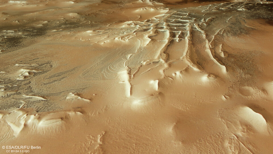
The apparent walls of Inca City trace part of a circle measuring about 86 kilometers in diameter. Scientists suspect the area lies inside a large impact crater created when a space rock struck the Martian surface. The collision may have fractured the surrounding plain, allowing lava to rise into the cracks before erosion exposed the harder material.
Other processes may have contributed to the unusual ridge system. Some structures could be hardened sand dunes, while others may be eskers, winding ridges of sediment associated with glaciers. Magma or sand moving through fractures in the crust could also have produced parts of the geometric pattern.
Erosion Shaped the Landscape Around the Spiders
Beyond the straight ridges, the Mars Express image contains rounded and oval patterns that resemble swirls in marble. ESA links these shapes to the gradual erosion of layered deposits, which exposes different materials as the upper surfaces wear away.
Steep-sided, flat-topped hills rise more than 1,500 meters above parts of the surrounding terrain. These landforms developed as wind, water or ice removed softer material and left more resistant rock standing above the eroded surface.
Smooth, pale dust covers parts of the northern side of the photographed area. Spider formations remain visible across some of these plateaus, mixed among canyons, troughs and other surface features.
Mars Express and the ExoMars Trace Gas Orbiter provide complementary views of the region. One records the wider terrain and dark surface deposits, while the other resolves the channel systems cut beneath the seasonal ice.
Enjoyed this article? Subscribe to our free newsletter for engaging stories, exclusive content, and the latest news.