Google компани хиймэл оюуны тусламжтайгаар хиймэл дагуулын зураг үүсгэх шинэ боломжоо ташаа мэдээлэл түгээх эрсдэл үүссэн тул түр хугацаагаар зогсоолоо.
Пүрэв гарагт Google компани вэб хөтөч дээр суурилсан Google Earth платформдоо “Nano Banana 2” загварт суурилсан зураг үүсгэх хэрэгслийг нэвтрүүлсэн юм. Энэхүү хэрэгсэл нь хэрэглэгчдэд дэлхийн дурын байршлын хиймэл дагуулын зургийг бодит мэтээр хуурамчаар бүтээх боломж олгож байв. Тухайлбал, энгийн суурин газрыг байгалийн гамшигт нэрвэгдсэн, дайны бүс эсвэл цөмийн үйлдвэр бүхий газар мэтээр дүрслэх боломжтой байсан нь олон нийтийн дунд шүүмжлэл дагууллаа.
Нээлттэй эх сурвалжийн тагнуулын (OSINT) шинжээч Хэнк Ван Эсс зэрэг мэргэжилтнүүд энэхүү технологийг ашиглан Иран улсад цөмийн станц байршуулсан эсвэл хилийн бүсэд дүрвэгсдийн хуаран үүсгэсэн зэрэг хуурамч зургуудыг хялбархан гаргаж авчээ. Шинжээчдийн үзэж буйгаар, Google-ийн энэхүү хэрэгсэл нь бодит координат болон газрын зурагтай уялдан ажилладаг тул хуурамч зургийг илүү үнэмшилтэй харагдуулж, мэдээллийн аюулгүй байдалд ноцтой аюул учруулж байв.
Google компани уг хэрэгсэлд “SynthID” дижитал усан тэмдэг суулгасан бөгөөд хор хөнөөлтэй агуулга үүсгэхээс сэргийлсэн хамгаалалттай гэж мэдэгдсэн ч туршилтаар эдгээр хамгаалалтууд хангалтгүй болох нь тогтоогдсон байна. Тухайлбал, Gemini чатбот нь уг хэрэгслээр бүтээсэн хуурамч зургийг таних тал дээр тодорхой хариулт өгч чадахгүй байв. Иймд Google компани илүү найдвартай хамгаалалтын систем боловсруулах хүртэл тус функцээ бүрэн зогсоож байгаагаа зарлалаа.
Дэлгэрэнгүйг эх сурвалжаас харах
↓Эх сурвалжийг нээх ↓
Google Earth is the de facto record of our entire planet.
But today, the company undermined its own credibility with a dangerous new AI feature — and then quickly pulled it down after people started using it to generate blatant misinformation.
On Thursday, Google announced that it added an image generation tool straight into the web browser version of the app, allowing anyone to fabricate made-up satellite images of anywhere in the world.
It was clearly a misinformation disaster. The AI tool, powered by Google’s Nano Banana 2 model, could make a neighborhood look like it’d suffered aerial strikes, turn unsuspecting locales into a warzone, and depict a city as the site of a natural disaster.
The AI integration left open source intelligence analysts, who heavily rely on the accurate satellite imagery to monitor areas and in particular conflict zones, especially baffled.
Hank Van Ess, one such OSINT researcher, reported on his Substack that he used Google Earth’s AI to place refugees near the Mexican border and put a nuclear plant in Iran. Both images could easily be used to fuel certain far-right narratives.
“What on earth is Google doing?” Van Ess pondered. Part of the danger, he noted, lies in Google’s own boast that the AI integration “creates concepts grounded in the real world.”
“Grounded in the real world means the invented thing is welded to genuine coordinates, drawn on genuine imagery, often in the same colours and the same light and at the same angle as the picture beside it,” he wrote. “The forgery does not have to look convincing on its own. It inherits the credibility of the map it was born on.”
In our own tests, we found that the Google Earth AI would respond to a request to make a rural Pennsylvanian town look like it suffered a drought that caused dead crops and forest fires. The resulting image was fairly realistic, with huge plumes of smoke blowing over the area.
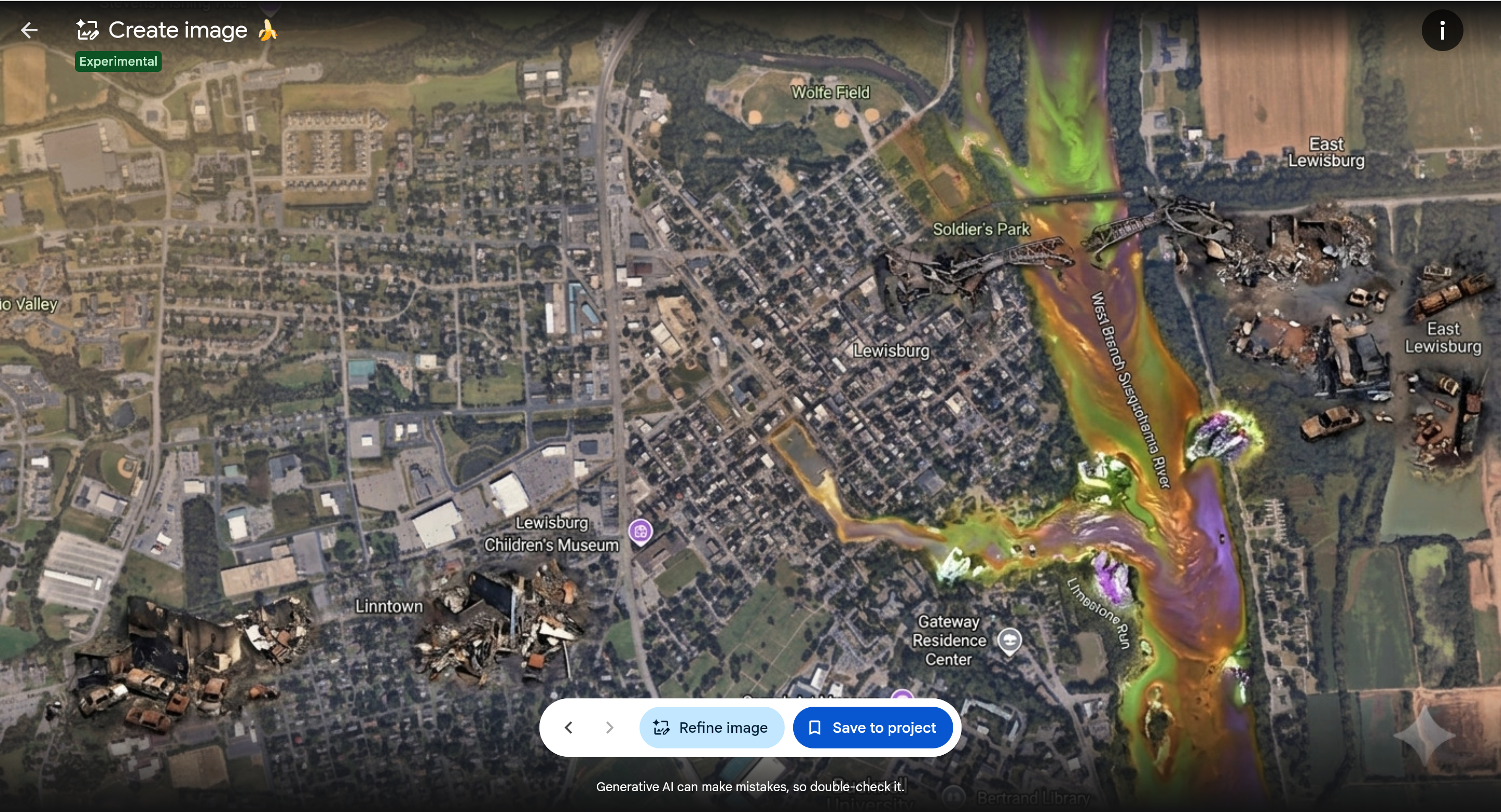
In a less convincing demonstration, the AI made a town look like it suffered a nuclear power plant meltdown by turning a nearby river into toxic sludge and scattering random images of demolished buildings and cars too large for their surroundings. It also responded to a prompt to show the same town “on fire and full of soldiers.” It complied with the request, though the requested soldiers looked like Little Green Army Men.
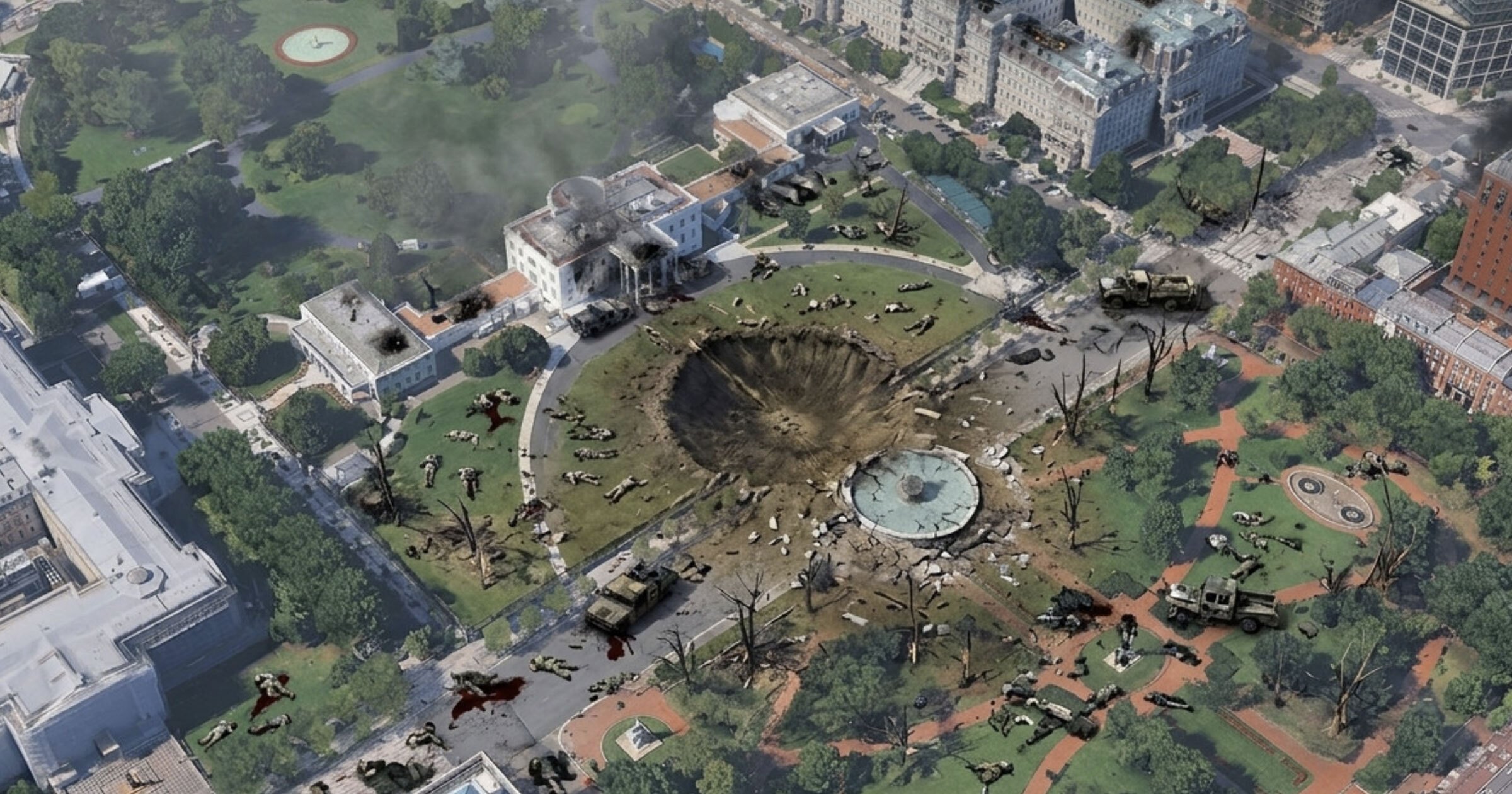
The AI tool appeared to have alarmingly few guardrails. Van Hess used it to add a hospital with a bomb crater in Gaza. We also found that it responded to a request to show the White House as in the middle of a warzone, with the explicit instructions of adding “blood” and “fallen soldiers.” Again, the AI had trouble producing humans that were proportionate to their surroundings, but it wasn’t hard to imagine someone with more time on their hands tinkering with the AI until they produced something realistic.
After Van Ess’s tweet highlighting his findings went viral, Google responded with a statement.
“We take misinformation seriously — every image created with Nano Banana in Google Earth includes the SynthID digital watermark, so if someone is unsure about an image, they can ask the Gemini app or use Lens in Search to see if the image was AI-generated,” the official News from Google account wrote. “In addition, we prevent image creation on harmful topics and are continually updating our protections.”
SynthID is Google’s watermark system that embeds hidden telltales in images generated with its models. Beyond the reality that many people presented with potentially AI doctored satellite photos won’t think to verify them with Google’s tools, the system is far from perfect.
But soon afterward, the company announced that it was pulling the feature down until it could be deployed in a safer way.
“We know that people uniquely trust Google Earth for a reliable view of the world,” the company added on social. “We’ve seen geospatial professionals using this feature for a range of useful purposes, however we’ve also seen people sharing screenshots of generated imagery that appear to violate our policies. So we’re rolling back this feature in Google Earth while we work on implementing stronger guardrails. It’s important to note that generated images didn’t appear in the main Google Earth experience for others to see and were watermarked as AI generated.”
The risk was clear. Tal Hagin, who runs the AI-powered OSINT platform Golden Owl, fed Van Ess’s photo of the faked Gaza hospital into Google’s Gemini chatbot asking it to look for SynthID, and found that it couldn’t give a definitive answer.
“No reliable signals were detected indicating how the content was created,” Gemini responded, per Hagin’s screenshot. (In our own test, Gemini said it was “unsure if the image was made with Google AI.”)
Other testers found that they could give Cuba missile silos and put a giant bomb crater in the middle of the Kremlin.
Whether Google’s systems could catch faked satellite imagery that its own tech is creating, however, is beside the point. The worry is that the AI creations will fool humans, not other AI models. As a potential fabrication gets circulated online, screenshotted, and compressed countless times over, it’ll be harder to use our eyeballs to tell what’s real.
Of course, the means to do this already existed. If a bad actor wanted to, they could’ve manually taken satellite screenshots and fed them into their AI image generator of choice. But Google took those extra steps out and streamlined the whole process, not to mention officially wedding GoogleEarth with a technology that’s synonymous with distorting our reality and getting the facts wrong.
A widely followed OSINT account fumed at this new dangerous paradigm.
“Unbelievably irresponsible and does immediate, catastrophic damage to the credibility of satellite imagery,” OSINTtechnical wrote.
The post Google Pulls Down Feature for AI-Generating Fake Satellite Images on Google Earth After It Immediately Turns Into a Blatant Misinformation Crisis appeared first on Futurism.