Хиймэл дагуулын мэдээлэлд үндэслэн гамшиг болохоос өмнөх долоо хоногуудад мөсөн гол болон чулуулгийн тогтолцооны хурд нэмэгдэж байсныг судлаачид тогтоов.
Наймдугаар сарын 26-нд Непал, Төвдийн хилийн ойролцоо мөсөн гол болон хад чулуу нурсны улмаас хүчтэй үер бууж, 1000 гаруй хүний амь нас эрсдэн, 4000 гаруй хүн сураггүй алга болоод байна. Virginia Tech-ийн геофизикч Манучехр Ширзаеийн судалгаагаар, гамшиг болохоос өмнөх долоо хоногуудад мөсөн голын хэсэг болон түүний доорх чулуулгийн хөдөлгөөн хурдассан нь системийн тогтворгүй байдлын шинж тэмдэг байж болзошгүй гэж үзжээ. Гэсэн хэдий ч тухайн үйл явдлын дараалал тодорхойгүй хэвээр байгаа бөгөөд асар том хэмжээний нуралт мөсөн голыг чирч унагасан уу, эсвэл мөсөн гол түрүүлж нурснаар чулуулгийг тогтворгүйжүүлсэн үү гэдэг нь одоогоор тогтоогдоогүй байна.
Судлаачид ESA-ийн Sentinel-1 хиймэл дагуулын 1-р сарын 8-наас 8-р сарын 18-ны хооронд цуглуулсан радарын өгөгдөлд дүн шинжилгээ хийжээ. Шинжилгээгээр мөсөн гол болон чулуулгийн бүс сард ойролцоогоор 10 миллиметрийн хурдтайгаар доошилж байсныг илрүүлсэн байна. Мөсөн голын хөдөлгөөний хурд нэмэгдэж байгаа нь тухайн бүс нутагт хэв гажилт өөрчлөгдөж байсныг харуулж байгаа тул энэхүү хурдатгалыг анхаарал татах голомт гэж үзэх боломжтой байв.
Гэвч ийм төрлийн гамшгийг урьдчилан таамаглахад хүндрэлтэй байгааг мэргэжилтнүүд онцолж байна. Ихэнх хяналтын системүүд нь мөсөн голын нуурын үерийг хянахад чиглэдэг болохоос өндөр уулын мөсөн гол болон чулуулгийн гэнэтийн нуралтыг шууд урьдчилан таамаглахад зориулагдаагүй байдаг. Түүнчлэн ийм бүс нутгууд алслагдсан, хүрэхэд хүндрэлтэй, газар дээрх байнгын хяналтын багаж хэрэгсэл дутагдалтай байдаг нь хүндрэл учруулдаг.
Одоогийн байдлаар эдгээр үр дүн нь урьдчилсан шинж чанартай бөгөөд судлаачид хэв гажилтын хэв шинжийг гамшгийн дараах дүрстэй харьцуулан судалж байна. Цаашид мөсөн гол болон чулуулгийн хөдөлгөөний хурдатгалыг тогтмол ажиглаж, түүнийг үер болон нурангийн загварчлалтай холбох боломжтой хиймэл дагуулын систем шаардлагатай байгааг мэргэжилтнүүд тэмдэглэв.
Дэлгэрэнгүйг эх сурвалжаас харах
↓Эх сурвалжийг нээх ↓
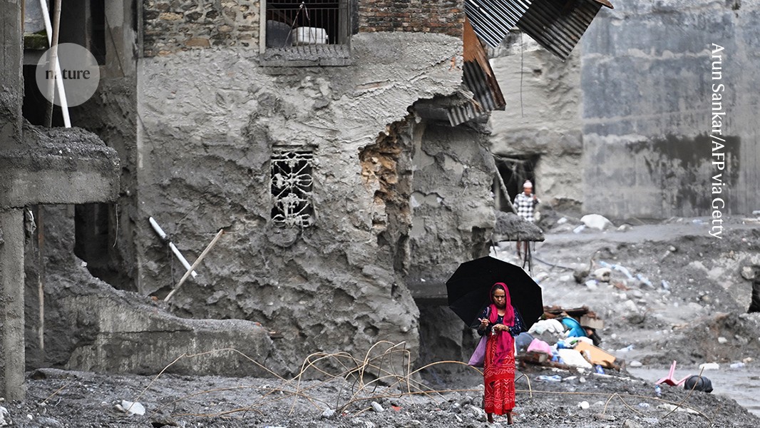
The flash flood destroyed many buildings and left villages covered in mud and debris.Credit: Arun Sankar/AFP via Getty
The high-altitude collapse of rock and ice that triggered a catastrophic flash flood near the Nepal–Tibet border on 26 August has so far claimed more than 1,000 lives. More than 4,000 people remain missing.
Manoochehr Shirzaei, a geophysicist at Virginia Tech in Blackburg, says that satellite images from just days before the disaster suggest that a section of the glacier and the rocks it sat on top of were accelerating in the weeks before the collapse, a concerning sign of an unstable system. The precise sequence of events remains unclear. The disaster might have begun with a massive rockslide that dragged part of the glacier downhill, or the glacier might have failed first causing rocks to destabilize into a landslide.
As Shirzaei tells Nature, such an event is difficult to predict using existing monitoring techniques. What is needed are systems that can detect glacier and rock collapses that pose cascade risks and can result in landslides and downstream flooding, he says.
What made this event difficult to predict?
It was particularly difficult to anticipate because it seems to have originated from the sudden failure of a high-elevation glacier–rock system, rather than a more routinely monitored trigger, such as extreme rainfall or the gradual rise of water in a known glacial lake. These high-mountain areas are remote, difficult to access and generally lack continuous monitoring with ground-based instrumentation.
Many glaciers and rock slopes move continuously without collapsing. Most existing monitoring systems are not designed to routinely examine thousands of glaciers and unstable mountain slopes for subtle changes in deformation.
The transboundary setting adds another challenge. The region where the cascade originated is close to, or across, the Nepal–Tibet border, so effective warning alerts also depend on the rapid sharing of observations and hazard information between countries.
What was visible in satellite observations before the event?
We analysed radar data from the European Space Agency’s Sentinel-1 satellites that were acquired between 8 January and 18 August. The last observation was only seven days before the disaster.
We detected evidence that the glacier–rock system was slowly moving downhill near the apparent collapse area, with velocities reaching roughly 10 millimetres per month. Glaciers can move at speeds of roughly 10–200 metres per year, so a slope moving steadily at 10 mm a month for years might not seem particularly alarming.
More importantly, our analysis also indicates acceleration of rock and ice near the potential failure zone. The acceleration is more important than the velocity, because it suggests that the rate of slope deformation was changing in the days leading up to the disaster.
The exact timing of the collapse was hard to forecast. The acceleration alone would not have told us ‘collapse imminent, evacuate now’. Rather, had the signals been identified before the collapse, the area could have been flagged as a hotspot warranting closer attention and monitoring.
These results are still preliminary. We are comparing the deformation pattern with images of the site after the event. We also need to rule out other possibilities.
Do warning systems for such events exist?
Most existing systems focus on glacial-lake outburst floods rather than directly forecasting catastrophic glacier–rock collapses.
At Cirenmaco glacial lake in Tibet, researchers developed a system that monitors the lake level, ice and rock collapses and downstream runoff, among other variables. Information is transmitted in real time1 through satellite and mobile communications, specifically with the goal of identifying precursor events and issuing warnings for downstream communities.
Nepal has experience as well. Systems in the Khumbu region incorporate water-level sensors, weather stations and automatic sirens for glacial-lake hazards.
What is still largely missing is a regional satellite-based system that routinely searches for accelerating glacier and rock-slope deformation and then connects that information directly to downstream flood and avalanche modelling.

