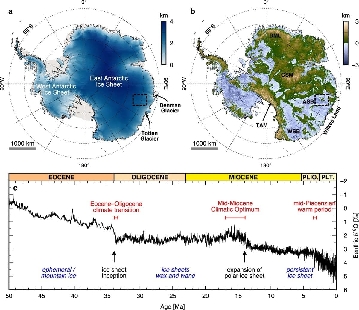
Эрдэмтэд хиймэл дагуулын өгөгдөлд тулгуурлан Дорнод Антарктидын мөсөн бүрхүүлийн дор нуугдсан, гол мөрнөөр сийлэгдсэн эртний ландшафтыг олж тогтоожээ.
Даремын их сургуулийн судлаач Стюарт Жэймисон тэргүүтэй баг Канадын RADARSAT хиймэл дагуулын мэдээллийг ашиглан Антарктидын мөсөн бүрхүүлийн гадаргуу дахь нарийн өөрчлөлтүүдийг шинжилж, мөсний доорх хөндий, нуруу болон сувгуудын бүтцийг зурагласан байна. Уэльс улсын хэмжээтэй дүйх энэхүү газар нутаг нь 34 сая гаруй жилийн турш мөсөн дор хадгалагдан үлдсэн бөгөөд мөсөн бүрхүүл үүсэхээс өмнөх үеийн байгалийн дүр төрхийг агуулж байгаа ажээ. Судлаачид энэхүү олдворыг мөсөн дор битүүмжлэгдсэн “цаг хугацааны капсул” хэмээн тодорхойлж байна.
Судалгааны баг хиймэл дагуулын өгөгдлийг баталгаажуулахын тулд агаарын радио-эхо дуугаралтын судалгаа болон газрын гадаргуугийн хувиралтыг тооцоолох загварчлалыг ашиглажээ. Шинжлэх ухааны үүднээс авч үзвэл, Антарктид тив 34 сая жилийн өмнө Гондвана супер тивийн нэг хэсэг байхдаа гол мөрөн урсаж, ой мод ургасан байгальтай байв. Эоцен-Олигоцены шилжилтийн үед дэлхийн температур эрс буурч, агаар мандал дахь нүүрстөрөгчийн давхар ислийн хэмжээ багассанаар мөсөн бүрхүүл үүсэж эхэлсэн байна.
Энэхүү нээлт нь мөсөн бүрхүүл хэрхэн өөрчлөгдөж ирсэн болон түүний доорх ландшафт цаг хугацааны явцад ямар байсныг ойлгоход чухал ач холбогдолтой юм. Судлаачид мөсөн бүрхүүл дэлхийн уур амьсгалын өөрчлөлтөд хэрхэн хариу үйлдэл үзүүлэхийг судлах нь нэн тэргүүний зорилт гэж үзэж байна. Ялангуяа, далайн түвшний өсөлтөд нөлөөлж болзошгүй Аурора болон Уилксийн мөсөн сав газруудын эмзэг байдлыг судлах ажил үргэлжилж байгаа бөгөөд цаашид одоогоор зураглагдаагүй үлдсэн хэсгүүдийг судлахаар төлөвлөж байна.
Дэлгэрэнгүйг эх сурвалжаас харах
↓Эх сурвалжийг нээх ↓
Scientists have identified an ancient, river-carved landscape hidden beneath the East Antarctic Ice Sheet, untouched for more than 34 million years. Roughly the size of Wales, the terrain was mapped using satellite technology capable of detecting minute changes on the ice surface above it.
The East Antarctic Ice Sheet stretches across more than 10 million square kilometers, and for decades it has kept whatever lies beneath it largely out of reach. What makes this discovery notable isn’t simply that a landscape exists under the ice, that much has long been suspected, but that it appears to have been preserved in something close to its original form, sealed away since a time when Antarctica looked nothing like it does now.
That earlier Antarctica was part of Gondwana, the supercontinent it once shared with Africa, South America, and Australia. Rivers flowed across it, forests grew, and dinosaurs roamed its surface. The transformation into today’s frozen landmass began roughly 34 million years ago, and understanding exactly how that shift occurred, and how the buried terrain survived it, is what drove the research team’s work.
How Satellites Uncovered a World Beneath the Ice?
The discovery is credited to a team led by Stewart Jamieson at Durham University, working with data from RADARSAT, the Canadian satellite constellation. According to the research team, it can pick up on subtle irregularities in the ice surface that indirectly reveal the contours of the land trapped below it. By tracking these small variations across the ice sheet, the researchers were able to piece together the shape of valleys, ridges, and channels carved long before any ice existed there.
“It’s like uncovering a time capsule,” Jamieson said of the find. He added that the state of the landscape points to its age, noting that it “must be a very old landscape carved by rivers before the ice sheet itself grew.”
The team backed up the satellite data with radio-echo sounding surveys carried out through the International Collaborative Exploration of the Cryosphere through Airborne Profiling project, along with flexural modeling designed to test whether the region’s highland blocks were once part of a single, unified surface later cut apart by erosion and uplift.
A Lost Antarctica Found Under Ice
The landscape now visible beneath the ice tells the story of a fundamentally different Antarctica. Before glaciation, fluvial erosion, the gradual carving of land by rivers, shaped the terrain into the valleys and channels researchers are now mapping. That process came to a halt as the East Antarctic Ice Sheet began forming during the Eocene-Oligocene transition, around 34 million years ago, when global temperatures dropped sharply and atmospheric CO2 fell below a critical threshold.
High-elevation regions, including the Gamburtsev Subglacial Mountains and the Transantarctic Mountains, served as the starting points for the ice sheet’s growth, acting as nuclei around which glaciers expanded before eventually merging into the continental-scale ice mass that covers the region today.

The ice sheet has not remained static since then evidence from marine sediments points to periods of retreat during warmer intervals, including the mid-Pliocene warm period and several interglacial phases of the Pleistocene, each leaving its own mark on the terrain below.
What This Lost World Reveals Today?
Beyond its value as a geological curiosity, the buried terrain gives researchers a way to study how the East Antarctic Ice Sheet has behaved across long stretches of time. As Jamieson put it:
“Understanding how this massive sheet might respond to human-driven climate change is a pressing concern.”
That concern is especially relevant for low-lying, marine-based sectors of the ice sheet, such as the Aurora and Wilkes Subglacial Basins, which the study, published in the journalNature Communications, identifies as particularly vulnerable to retreat during warm periods, with implications for global sea levels.

Jamieson also said that the team intends to keep exploring the buried landscape, working to fill in the gaps left by areas that haven’t yet been surveyed. He added that:
“Using that information to understand how the ice sheet and its underlying landscape have changed over their long history.”
Enjoyed this article? Subscribe to our free newsletter for engaging stories, exclusive content, and the latest news.

