Хөлбөмбөгийн талбайтай тэнцэх хэмжээний энэхүү эртний байгууламжийг хиймэл дагуулын радарын тусламжтайгаар газрын гүнээс илрүүлсэн байна.
Египетийн Нил мөрний бэлчир дэх эртний Буто (өнөөгийн Телл эль-Фараин) хотын нутаг дэвсгэрт хийсэн судалгаагаар 2600 жилийн настай томоохон байгууламжийг илрүүлжээ. Археологичид Европын сансрын агентлагийн Sentinel-1 хиймэл дагуулын радарын зураглал болон цахилгаан эсэргүүцлийн томографийн (ERT) арга ашиглан газрын гүн дэх бүтцийг хөндөхгүйгээр судалсан байна. Ингэхэд 128 метр урт, 62 метр өргөн хэмжээтэй, эртний Саитын үед (МЭӨ 688–525 он) хамаарах тоосгон байгууламж илэрчээ.
Судлаачид тус байгууламжийн суурийн хэсгээс элсээр хийсэн зузаан давхаргыг олсон нь шинжлэх ухааны хувьд онцгой ач холбогдолтой юм. Нил мөрний бэлчирийн шаварлаг хөрс нь чийг шингээж тэлэх, хатахдаа агших шинж чанартай тул барилга байгууламжид эрсдэлтэй байдаг. Эртний барилгачид энэхүү байгалийн нөхцөлийг сайтар ойлгож, барилгын жинг жигд хуваарилах, гүний ус зайлуулах зорилгоор цэвэр элсэн суурь ашигласан нь тогтоогджээ.
Маргааш нь хийсэн малтлагаар тус байгууламжийн ойролцоогоос нас барагсдад зориулсан “ушабти” буюу зарц баримал, амьтны цусны үлдэгдэлтэй тахилын ширээ, мэргэн ухааны бурхан Тотын бэлгэдэл болсон бабүүний баримал зэргийг олж илрүүлсэн байна. Судлаач Абделазиз Эльфадалийн тайлбарласнаар, энэхүү том хэмжээний байгууламж нь сүм, санваартны сууц эсвэл булш байх магадлалтай. Энэхүү олдвор нь Саитын үеийн фараонууд Нил мөрний бэлчир бүс нутгийг шашны хувьд хэрхэн бэхжүүлж байсныг батлан харуулж байна.
Дэлгэрэнгүйг эх сурвалжаас харах
↓Эх сурвалжийг нээх ↓
Egyptian researchers have found a hidden 2,600-year-old structure the size of a football field after using satellites to peer below the ground. But what they found beneath the structure may be just as remarkable as the building itself.
The site they examined is known as Buto (modern-day Tell el-Fara’in), a sprawling mound of layered history in the northwestern Nile Delta. To the ancient Egyptians, it was the sacred home of Wadjet, the cobra goddess of Lower Egypt, and one of the most religiously important cities in the pharaonic landscape.
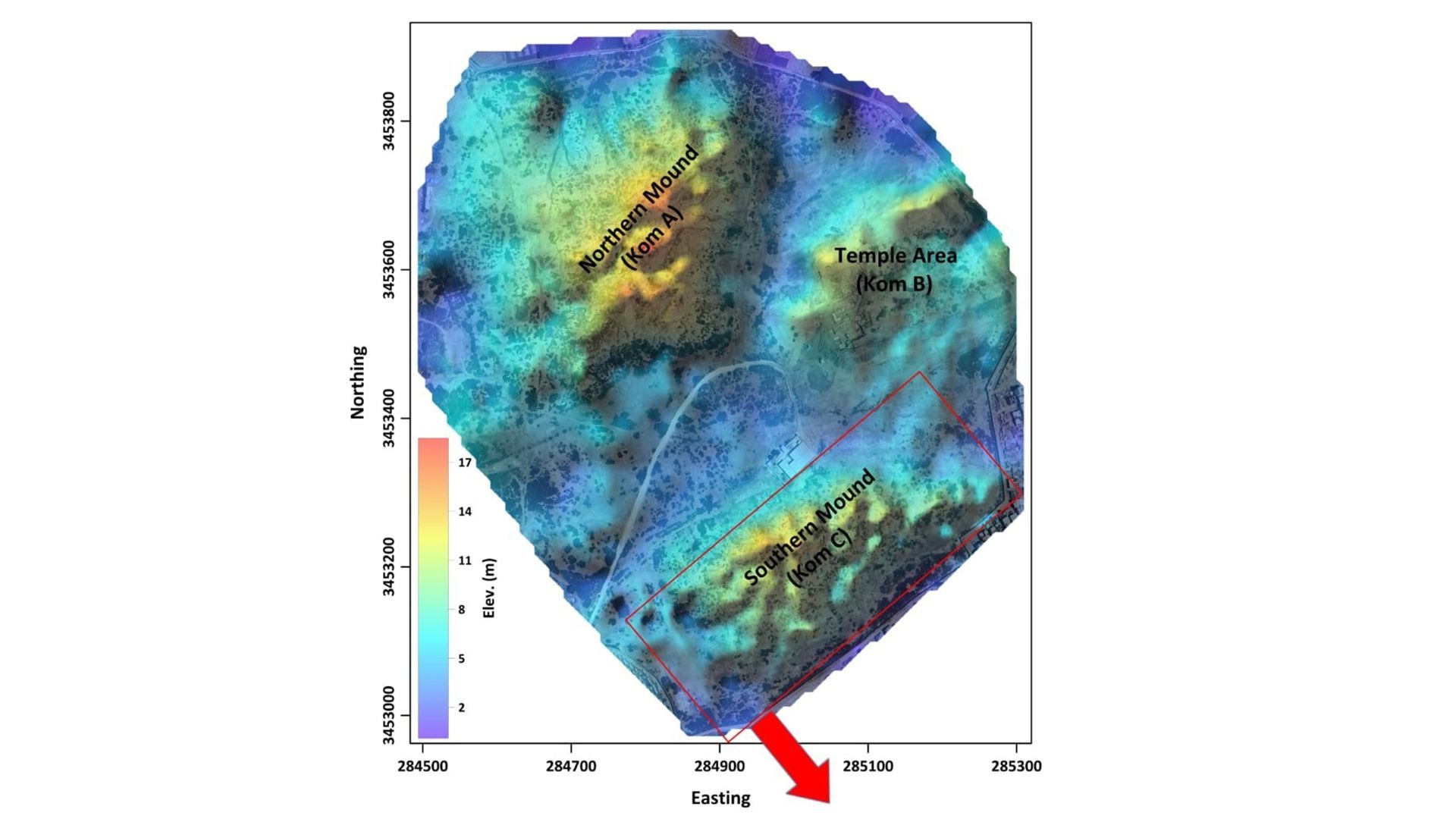
Archaeologists have excavated its upper layers for decades, finding remains from the rule of the Macedonian Ptolemaic dynasty (305 to 30 B.C.) and Roman era (30 B.C. to A.D. 395). But the deeper, older layers at the site — including a mound called Kom C, sitting below groundwater level in waterlogged delta clay — had stayed stubbornly out of reach. Kom C itself rises above the surface as a visible mound, but earlier excavations had reached only the Ptolemaic and Roman layers before hitting the water table.
Now, researchers have turned to noninvasive tools, including satellite imagery, to delve into the mysterious subterranean layers.
First, they turned to the European Space Agency’s Sentinel-1 satellite, which can produce radar images by beaming down microwave pulses from orbit and then measuring how they reflect back; the returning signals can reveal subtle differences in surface moisture, elevation and reflectivity that can hint at buried structures beneath the ground. After looking at these radar images, the team spotted a large oval-shaped anomaly buried beneath Kom C that was 420 feet long and 203 feet wide (128 by 62 meters).
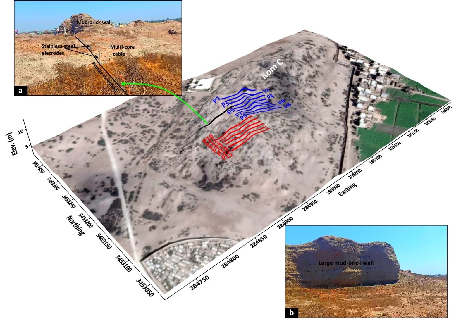
To learn more without disturbing the site, the team ran 15 parallel lines of electrical resistivity tomography (ERT) across an area of roughly 58,100 square feet (5,400 square meters). This technique reveals the underground landscape by passing electrical currents through the earth, measuring how they travel and creating a map that archaeologists can read.
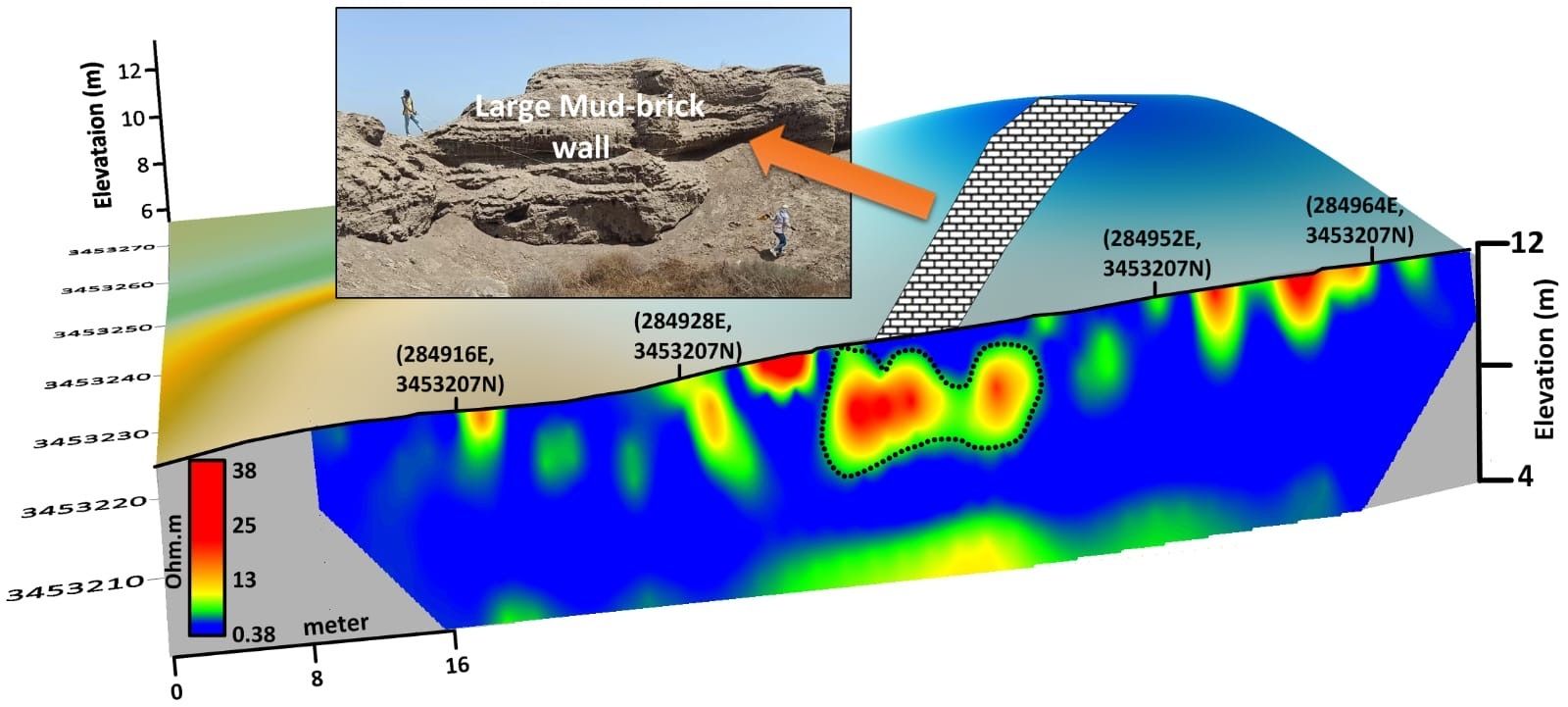
The picture that came back was layered. Between the surface and 10 feet (3 m) down, the team found scattered Ptolemaic and Roman debris, including displaced mudbricks, pottery shards and broken limestone, which point to centuries of continued occupation and rebuilding on the site. Later residents dismantled older structures for reuse and left a scatter of displaced material behind.
Using pure sand as a stabilizing cushion was a brilliant, deliberate tactic — the ancient builders profoundly understood their environment.
Hussein Bassir, director of the Antiquities Museum at Bibliotheca Alexandrina
Deeper still, between 10 and 20 feet (3 and 6 m), the researchers found a large mudbrick structure from the 26th dynasty (688 to 525 B.C.), also known as the Saite period. They were able to date this discovery based on its layer, the unique shape of the mudbricks and other artifacts such as pottery, which the team dated by style and their archaeological layer, with carbon-14 dating applied to associated organic material. The large structure may be a tomb, a house for priests or a religious shrine, the team wrote in the study, published in March in the journal Acta Geophysica.
And below that, at 20 to 23 feet (6 to 7 m) underground, the researchers unexpectedly found a thick, clean layer of sand.
That sand is the discovery within the discovery, the team wrote in the study.
The Nile Delta’s clay is notoriously treacherous to build on. It absorbs moisture and swells, and then contracts and shifts as it dries — posing a slow-motion threat to anything heavy sitting on top of it. The Saite builders, it seems, knew this. Before laying the foundations to their structure, they packed a cushion of clean sand beneath it. This sand would have spread the building’s weight, let groundwater drain through, and stopped the clay from creeping. It is the same logic behind modern load-distributing foundations — applied here more than two and a half millennia ago.
“By combining satellite radar with deep ERT profiles, we didn’t just map the walls of this massive Saite-era structure — we were also able to analyze the subsurface layers,” study co-author author Abdelaziz Elfadaly, an associate research professor at Egypt’s National Authority for Remote Sensing and Space Sciences, told Live Science. “The detection of a significant, clean sand foundation layer beneath the mudbrick walls explains how these heavy structures survived the high water table and shifting clayey soil of Buto.”
The sand layer, in effect, acts as a barrier; it stops groundwater from wicking upward into the mudbrick, which would soften and dissolve it. The sand also lets water drain sideways instead of pooling against the foundation, according to Elfadaly.
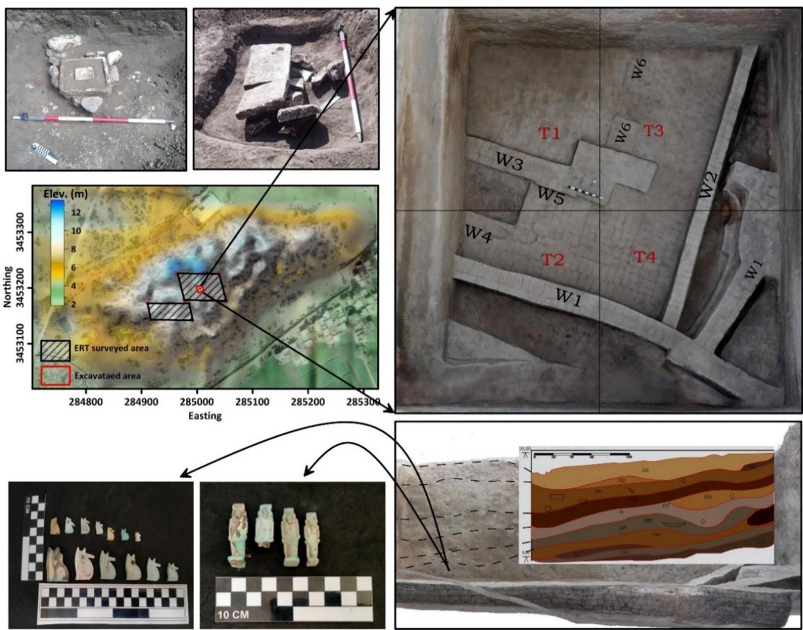
A 3-by-3 foot (10 by 10 m) excavation trench that was around 20 to 23 feet (6 to 7 m) deep confirmed the presence of thick mudbrick walls resting on that sand layer, and nearby, a spread of objects that hint at the site’s sacred function. According to Elfadaly, these finds included ushabti and shawabti figurines — small servant statues typically placed in tombs to serve the deceased in the afterlife — and a limestone altar whose carved channels bore dried residues consistent with animal blood, pointing to offering rituals performed at the site. The study also noted a rarer find: a faience baboon figurine, the kind associated with Thoth, the god of wisdom.
The Saite period was a moment of cultural revival. After generations of Assyrian and Libyan domination, Egyptian pharaohs retook the throne and poured resources into restoring Egypt’s religious landscape, particularly in the Nile Delta, which had been their power base. Buto, with its deep ties to Lower Egyptian identity, was a natural focus. The Saite kings ruled from the nearby delta city of Sais, so restoring Buto reinforced their roots and their claim to the throne.
“A monumental building of this scale underscores the Saite pharaohs’ intense commitment to glorifying the Delta region,” Hussein Bassir, director of the Antiquities Museum at a cultural research center known as Bibliotheca Alexandrina who wasn’t involved with the study, told Live Science in a WhatsApp message. “Using pure sand as a stabilizing cushion was a brilliant, deliberate tactic — the ancient builders profoundly understood their environment.”
The team is planning a return visit, this time using wider-spaced electrical resistivity surveys to reach deeper layers, along with specialists who study ancient plants and also understand how geological features changed over time, which may help reconstruct what the landscape around Buto looked like when these walls were first laid.
Are you a fan of mummies and hieroglyphs? Find out with our ancient Egypt quiz!