Судлаачид агаар мандалд чийг тээвэрлэн хур тунадасны хуваарилалтад нөлөөлдөг агаарын голдирлуудыг математик загварчлал болон цаг уурын мэдээлэл ашиглан илрүүллээ
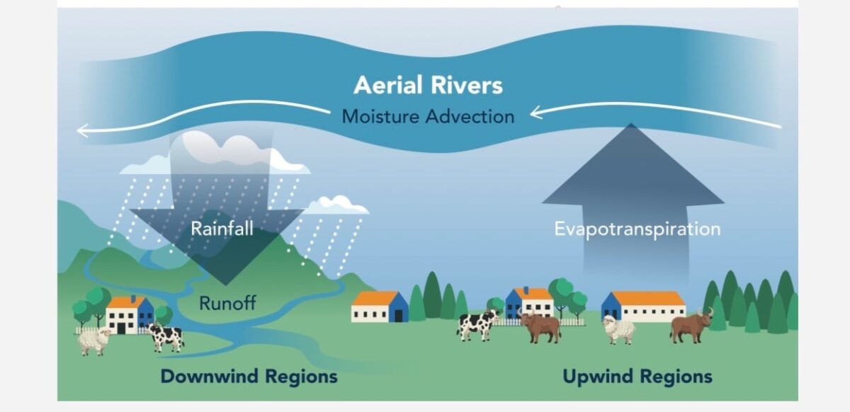
Эрдэмтэд Өмнөд Америк тивийн дээгүүр үргэлжлэн оршдог, агаар мандал дахь усны урсгалын цогц сүлжээг анх удаа зураглаж гаргажээ. Эдгээр “агаарын гол” нь газрын гадаргуу дээрх гол мөрөн шиг харагдахгүй ч хөрсний ууршилт болон ургамлын транспирацийн үйл явцаар дамжин агаар мандалд орсон чийгийг тивийн алс хол бүс нутаг руу тээвэрлэдэг байна. Эдгээр урсгал нь богино хугацаанд үргэлжилдэг агаар мандлын голдирлуудаас ялгаатай нь тогтвортой шинж чанартай ажээ.
Судлаачид агаарын голдирлуудыг шинж чанараар нь дөрвөн бүлэгт ангилж, тэдгээрийн хөдөлгөөн болон чийгийн хуваарилалтыг тодорхойлсон байна. Тухайлбал, G1 бүс нутаг нь далайгаас ирж буй чийгийг хүлээн авдаг эх үүсвэр болдог бол, G4 бүс нутаг нь чийг багатай, усны хомсдолтой хотуудыг агуулсан “агаарын тал” хэлбэрийн бүсүүд болохыг тогтоожээ. Гэсэн хэдий ч салхины чиглэл өөрчлөгдөхөд эдгээр урсгал нэг өдрийн дотор чиглэлээ солих боломжтой нь ажиглагдсан байна.
Ойн бүрхэвч алдагдах нь агаарын голдирлоор дамжих чийгийн тэнцвэрт сөргөөр нөлөөлж, алс хол орших бүс нутгийн хур тунадас болон урсацыг эрс бууруулдаг болохыг судалгаагаар нотолжээ. Жишээлбэл, Перу улсын Укаяли бүсэд хийсэн ажиглалтаар, ойн хомсдол нь жилийн хур тунадасны хэмжээг 5-13 хувиар, урсацыг 19-50 хувиар бууруулах эрсдэлтэй гэж дүгнэв.
Эдгээр агаарын урсгал нь засаг захиргааны болон газар зүйн хил хязгаарыг үл харгалзан дамждаг тул бүс нутгийн хэмжээнд институцийн хамтын ажиллагаа шаардлагатайг судлаачид онцолж байна. Энэхүү судалгааны аргачлалыг дэлхийн бусад бүс нутаг дахь агаарын голдирлуудыг судлахад ашиглах боломжтой юм.
Дэлгэрэнгүйг эх сурвалжаас харах
↓Эх сурвалжийг нээх ↓
Scientists have mapped a huge network of aerial rivers moving water through the atmosphere above South America. These invisible flows carry moisture across the continent and help determine where rain eventually falls, even though there is no riverbed or visible river in sight.
They are different from the better-known atmospheric rivers, which tend to be episodic and short-lived. Aerial rivers are persistent moisture pathways created by the combined effects of winds, from sea breezes and low-level jets to atmospheric rivers themselves.
And they can travel surprisingly far. Previous research found that moisture supplying Pakistan follows pathways stretching from Scandinavia to Madagascar. Now, researchers have turned their attention to South America, using mathematical modeling and observational climate data to follow water from the places where it enters the atmosphere to the regions where it comes back down as rain.
Tracking Water Across A Continent
The basic idea sounds simple: figure out where atmospheric moisture comes from and then follow where the winds take it. In reality, that means tracking a sprawling and constantly changing system.
The researchers identified dominant upwind basins, areas that provide much of the moisture carried toward other regions. Water enters these aerial rivers through several processes, including evaporation from soil and transpiration from vegetation, when plants release water vapor into the atmosphere.
The team also looked for “turning points.” These mark the distance beyond which the amount of moisture contributed by an upwind source to a particular region suddenly starts dropping. According to the study in Nature Communications, this approach allowed researchers to examine how far the aerial rivers travel, how fast they move and how much water they eventually release as rainfall.
There is one catch: these rivers do not stay put. The researchers note that shifting winds can reverse the direction of moisture flows toward coastal cities within a single day.
Map Of Four Hidden River Types
To make sense of the network, the researchers separated South America’s aerial rivers into four categories: G1, G2, G3 and G4. G1 regions are essentially the headwaters. This is where aerial rivers carrying ocean moisture enter the continent a and begin their journey across the continent. Despite that role, G1 areas are not always right on the coast. Then come G2 regions, where atmospheric drainage can increase and some water vapor can be lost as the flow travels inland.
Things look different in G3 regions. Here, those rivers slow sharply and contain much less moisture, leaving these areas more dependent on continental evaporation for rainfall. Some of them may also sit upstream of major river basins.

At the other end are G4 regions, compared in the study to atmospheric plains. As mentioned in the paper, they may be located farthest downwind, receive the least moisture from aerial rivers and tend to contain water-scarce cities.
Cutting Forests Changes Rain Far Away
The study team also puts forests squarely into the picture. Vegetation releases moisture into the atmosphere, so what happens to forests in an upwind basin can affect the water carried farther along an aerial river. The researchers highlight Peruvian Ucayali as one example. They write that research shows deforestation in upwind areas can contribute to a 5–13 percent drop in annual rainfall and a 19–50 percent decrease in annual runoff in the region through aerial rivers.

That is why the researchers point to forest preservation and reforestation, particularly in upwind basins, as key management goals. There is also a practical problem: an aerial river does not care about borders.
“These basins often transcend administrative and topographic boundaries,” the researchers explain. “Their effective management requires institutional collaboration among entities responsible for regional governance.”
The framework developed in the study can also be used to analyze aerial rivers and their dominant moisture sources elsewhere in the world.
Enjoyed this article? Subscribe to our free newsletter for engaging stories, exclusive content, and the latest news.