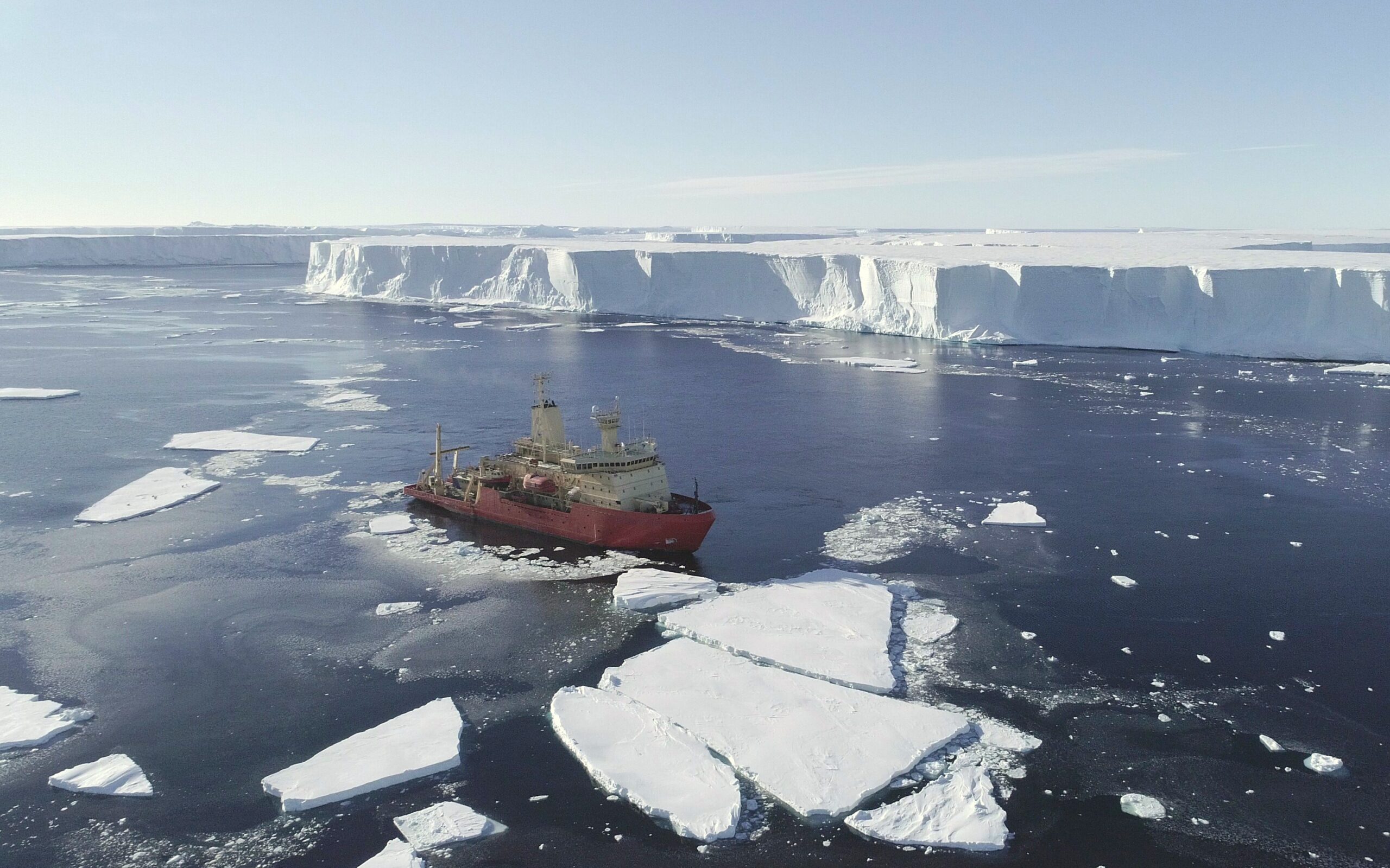
Готенбургийн их сургуулийн судлаачид Антарктидын Дотсоны мөсөн бүрхүүлийн доорх ёроолыг бие даан судалж байсан “Ran” шумбагч аппаратын тусламжтайгаар мөсөн доорх газарзүйн онцлог тогтоцуудыг нарийвчлан зураглав.
2022 онд явуулсан судалгаагаар “Ran” шумбагч 27 хоногийн турш 1000 гаруй километр замыг туулж, мөсөн бүрхүүлийн доорх хөндийн 140 хавтгай дөрвөлжин километр талбайг өндөр нарийвчлалтайгаар зурагласан байна. Олон туяат сонарын тусламжтайгаар авсан мэдээллээр мөсөн давхаргын доорх тэгш дэнжүүд, хагарал, элэгдлийн бүсүүд болон урьд өмнө харагдаагүй нулимс хэлбэрийн хонхорхойнуудыг илрүүлжээ. Эдгээр бүтэц нь далайн гүний дулаан урсгал, хурд болон мөсөн доорх турбулент урсгалын нөлөөгөөр үүссэн байж болзошгүй гэж судлаачид тайлбарлаж байна.
Судалгааны баг мөсөн доорх хайлалтын үйл явц нь бүс нутгаас хамааран эрс ялгаатай байгааг тогтоосон бөгөөд баруун хэсэгт мөс илүү хурдтай хайлах үзэгдэл ажиглагджээ. Энэхүү үйл явцад далайн гүний дулаан усны урсгал болон эргэлтийн нөлөө ихээхэн үүрэг гүйцэтгэдэг болохыг хэмжилтүүд баталсан байна. Мөн Дотсоны мөсөн бүрхүүл нь 1979-2017 оны хооронд дэлхийн далайн түвшний өсөлтөд 0.6 миллиметрийн хувь нэмэр оруулсныг тус судалгаа онцолжээ.
Гэвч 2024 оны нэгдүгээр сард судалгааг үргэлжлүүлэхээр очсон багийнхан “Ran” аппаратыг дахин ашиглах үед уг робот нэг удаагийн шумбалт хийгээд эргэн гарч ирээгүй байна. Эрэн хайх ажиллагаа ямар ч үр дүнд хүрээгүй тул уг төхөөрөмжийг мөсөн бүрхүүлийн гүнд үлдсэн гэж үзэж байгаа бөгөөд үүний улмаас тус бүс нутгийг дахин нарийвчлан харьцуулах боломж хязгаарлагджээ.
Дэлгэрэнгүйг эх сурвалжаас харах
↓Эх сурвалжийг нээх ↓
Under hundreds of meters of floating Antarctic ice, a bright orange robot was traveling where ships, satellites, and GPS could not follow. Ran, a seven-meter autonomous submarine, navigated preprogrammed routes beneath the Dotson Ice Shelf without continuous contact with the research vessel above. Once it disappeared into the cavity, the team could only wait for it to return.
During the 2022 field campaign, Ran spent 27 days surveying the cavity beneath Dotson in West Antarctica. It traveled more than 1,000 kilometers in total and reached 17 kilometers beneath the shelf, using upward-looking sonar while measuring currents, temperature, and salinity. Some missions lasted more than 24 hours beneath ice roughly 200 to 500 meters thick.
Anna Wåhlin, professor of oceanography at the University of Gothenburg, led the work with researchers from the International Thwaites Glacier Collaboration and partner institutions. They wanted to see the underside of the ice directly rather than infer its shape only from the surface. In January 2024, the team returned to repeat the surveys, but Ran completed only one dive before failing to resurface.
Sonar Exposed an Ice Landscape Hidden From Satellites
The 2022 data revealed what the surface could not show. Ran’s multibeam sonar produced six high-resolution maps covering about 140 square kilometers of the ice base, exposing terraces, channels, fractures, smooth eroded zones, and previously unseen formations. The Science Advances study, led by Wåhlin, found sharply different signs of melting across parts of the same ice shelf.

Across the eastern and central areas, the base contained flat terraces about 200 to 2,000 meters wide, bordered by steep faces roughly 0.5 to 5 meters high. Some terraces formed multiple levels, with groups reaching 5 to 40 meters in relief. The researchers linked those patterns to slower melting, convection, and intermittent intrusions of warmer water.
The western region looked markedly different. Its underside was smoother and more eroded, and the team documented clusters of teardrop-shaped divots that were not visible at the surface. Among the most prominent examples, the study measured an average width of 68 meters, with widths ranging from 20 to 170 meters.
Fast Water Carved the Western Ice From Below
Beneath Dotson, measurements showed slow currents of about 0.01 to 0.04 meters per second in the central and eastern areas. In the west, a meltwater-rich outflow reached speeds of up to 0.25 meters per second. That faster flow coincided with a region where observed basal melt rates reached about 15 meters per year.
Wåhlin’s team found that shear-driven turbulence and warm mixtures of modified Circumpolar Deep Water were consistent with the rapid melting in the western outflow. The teardrop features appeared only in this high-velocity region. The researchers proposed that friction and Earth’s rotation could turn flow within a 5- to 15-meter-thick boundary layer, helping produce the asymmetric shapes.
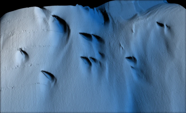
Teardrops were not the only marks cut into the shelf. Ran also mapped full-thickness fractures, some showing widening and erosion at their bases. Satellite records described in the research indicated that the oldest fractures in one survey area became visible at the surface in the 1990s, while younger fractures were only about two to five years old when mapped.
A Second Robot Found More Complexity in the Same Cavity
A separate study published in Ocean Science in 2025 provided another view of the water beneath Dotson. Maren Elisabeth Richter of the University of East Anglia and colleagues used an AutoSub Long Range vehicle to collect more than 100 kilometers of seabed dive-track data, including measurements of current velocity and turbulent mixing. Their results found sharp variations in mixing across the cavity rather than a uniform pattern.
Background turbulent dissipation rates were around 10^-10 watts per kilogram, with localized patches near 10^-8 watts per kilogram. Average vertical heat fluxes were about 0.1 watts per square meter, while the maximum reached 52 W/m². Stronger mixing appeared where currents accelerated along slopes, vertical shear increased, and the seabed became steeper.

That study placed Dotson within a longer record of West Antarctic ice loss. Citing the 2019 mass-balance analysis led by Eric Rignot of the University of California, Irvine, the authors reported that Dotson contributed about 0.6 millimeters to global mean sea-level rise between 1979 and 2017. They also noted that warm deep water can enter the cavity and reach deep grounding lines.
Ran Vanished Before the Team Could Repeat the Map
The chance to compare the mapped features directly with a later survey ended in February 2024. On Ran’s final planned mission, the vehicle failed to return to its rendezvous point beneath Dotson. Searches using acoustic instruments, a helicopter, and drones found no trace of it, and the vehicle was believed to remain deep beneath the ice shelf.
The loss left the 2022 survey as Ran’s most detailed map of this hidden terrain. The study found that convection, turbulence, warm-water intrusions, fractures, and boundary-layer flow could leave different physical marks on the same ice shelf. Its six mapped areas extended as far as 17 kilometers into the Dotson Ice Shelf cavity.
Enjoyed this article? Subscribe to our free newsletter for engaging stories, exclusive content, and the latest news.