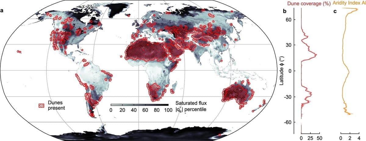
Монашийн их сургуулийн судлаачид хиймэл дагуулын зураг болон өндрийн нарийвчилсан мэдээлэлд тулгуурлан дэлхийн элсэн манхны тархалтыг харуулсан анхны иж бүрэн атласыг бүтээжээ.
Nature Communications сэтгүүлд нийтлэгдсэн энэхүү судалгаа нь салхи, уур амьсгал, геологийн хүчин зүйлс элсэн манхны тогтоц болон хөдөлгөөнд хэрхэн нөлөөлдгийг тайлбарласан байна. Эрдэмтэд хуурай бүс нутагт салхины чиглэл болон элсний нөөц гол үүрэг гүйцэтгэдэг бол ургамал бүхий чийглэг бүсэд манхан үүсэх үйл явц илүү төвөгтэй байдгийг тогтоожээ. Энэхүү мэдээллийн сан нь элсэн манхан үүсэхэд нөлөөлдөг олон талт хүчин зүйлсийг нэгтгэн харуулснаараа онцлог юм.
Судлаач Эндрю Ганн элсэн манхан нь тухайн бүс нутгийн уур амьсгал, геологийн түүхийг хадгалдаг “байгалийн архив” болохыг онцолсон байна. Дэлхийн манхны тогтцыг ийнхүү зурагласнаар эрдэмтэд Ангараг гаригийн гадаргуу дээрх салхины идэвхжил болон гадаргын материалын найрлагыг судлах шинэ жишиг үзүүлэлттэй болж байна. Ангараг гаригийн гадаргуу дээрх хавирган сар хэлбэрийн манхан нь салхины чиглэл болон тунадасны шинж чанарыг тодорхойлоход чухал ач холбогдолтой юм.
Энэхүү судалгааны үр дүн нь зөвхөн өнгөрсөн үеийн уур амьсгалыг сэргээн босгоход төдийгүй ирээдүйн өөрчлөлтийг хянахад чухал ач холбогдолтой. Шинэ атлас нь салхины хэв шинж, хуурайшилтын явц болон элсний нүүдэл хэрхэн өөрчлөгдөж байгааг бодит цаг хугацаанд ажиглах боломжийг олгож байна. Ингэснээр цаг уурчид цөлжилт болон салхины эрчимтэй элэгдлийн улмаас газар нутаг хэрхэн өөрчлөгдөхийг урьдчилан таамаглах илүү нарийвчлалтай хэрэгсэлтэй боллоо.
Дэлгэрэнгүйг эх сурвалжаас харах
↓Эх сурвалжийг нээх ↓
Scientists have created the most detailed global map of Earth’s sand dunes ever produced, revealing how wind, climate, and geology shape these constantly changing landscapes. The new dataset could also help researchers better understand Mars, where they are among the few surface features offering clues about the planet’s environment.
The study, led by researchers from Monash University, combines satellite imagery and high-resolution topographic data to build a worldwide atlas of dune systems. Published in Nature Communications, the research explains why dunes form in certain regions and provides a new reference for studying landscapes on Earth and beyond.
Sand dunes may appear simple, but they contain a record of the conditions that shaped them. Their forms are influenced by wind patterns, sediment availability, vegetation, and local geology. Scientists study these features to reconstruct past climates on Earth and investigate distant planets where direct measurements remain limited.
For years, researchers have lacked a detailed global dataset showing where dunes exist and what environmental factors control their formation. The new map, created by Dr. Andrew Gunn from the School of Earth, Atmosphere and Environment at Monash University, shows a consistent overview of dune systems across the planet.
The World’s Sand Dunes Finally Mapped
The research team examined global satellite images and detailed elevation data to identify and categorize dune systems. Researchers from Monash University found that dune formation follows different patterns depending on climate and surface conditions.
In dry environments, they are mainly shaped by the relationship between wind movement and available sediment. Areas where winds converge can collect and transport sand, while the distance from a sediment source determines whether enough material is available for dune development.
In wetter regions with more vegetation, the process becomes more complex. Plants can stabilize the ground and reduce the movement of loose sediment, meaning stronger winds are required to create active ones.
The paper shows that dune formation results from a combination of environmental factors rather than one single cause. The global atlas allows scientists to compare dune fields in different parts of the world and better understand the forces that shape them.
Earth’s Dunes Help Scientists Read The Surface Of Mars
The research also highlights how dune patterns can provide information about other planets. On Mars, they are among the few visible surface features that can reveal details about wind activity and the composition of surface materials.
Crescent-shaped dunes known as barchans are particularly useful because their shape can indicate wind direction and provide clues about sediment properties. The researchers explain that these formations act as natural indicators of the conditions in which they developed.

The findings are especially relevant for Mars, where direct climate observations are extremely limited. By comparing Martian dunes with well-studied examples on Earth, scientists can improve their understanding of the Red Planet’s surface processes. As explained by Dr. Andrew Gunn:
“Sand dunes can serve as natural archives of climate and geological history. Having a consistent, worldwide map allows us to better understand how wind-shaped landscapes evolve across our planet today, offering a clearer benchmark when analyzing similar features in the rock record or on planets like Mars.”
A New Way To Study Earth’s Evolving Landscapes
The dataset serves as a shared reference for geologists, climate scientists, and planetary researchers alike, mapping landscapes on Earth and across the solar system. Monash University’s team notes it could help monitor changes in wind patterns, arid regions, and wind-driven erosion using its detailed record of dune locations.
This global view of Earth’s dune systems also offers a valuable comparison point for studying similar formations on other worlds. The physical processes that shape terrestrial dunes can help scientists interpret features observed millions of kilometers away.
“As global climate patterns shift, this map gives us a baseline to track how wind systems and drylands are changing in real time. Beyond looking backward at Earth’s history, it gives climate modelers a crucial tool to predict how desertification and wind-driven erosion might reshape communities in the decades ahead,” concluded Gunn.

Enjoyed this article? Subscribe to our free newsletter for engaging stories, exclusive content, and the latest news.