Судлаачид байгаль орчны хяналтын өгөгдлийг дахин шинжилснээр өмнө нь бүртгэгдээгүй байсан томоохон суурин газрыг олж тогтоов.
Мексикийн Кампече мужийн ойд, хөл хөдөлгөөн ихтэй хурдны замын хажууд Майя иргэншлийн эртний хот нуугдаж байсныг судлаачид санамсаргүй байдлаар илрүүлжээ. Люк Олд-Томас тэргүүтэй эрдэмтэд 2013 онд ойн талбайг хянах зорилгоор цуглуулсан LIDAR буюу лазерын зураглалын өгөгдлийг археологийн судалгааны аргаар дахин боловсруулснаар Валериана хэмээх энэхүү эртний хотын үлдэгдлийг олсон байна.
Тус хотын туурь нь 16.6 хавтгай дөрвөлжин километр талбайг хамардаг бөгөөд дурсгалт барилга байгууламж бүхий хоёр том бүсээс бүрддэг. Энд пирамид, талбай, бөмбөг тоглоомын талбай, усан сан зэрэг иргэншлийн ул мөр илэрсэн нь уг суурин нь сонгодог үеийн Майя иргэншлийн улс төрийн төв байсныг илтгэж байна. Архитектурын хэв шинжийг нь үндэслэн судлаачид уг хотыг МЭ 150 оноос өмнө байгуулагдсан гэж таамаглаж байгаа юм.
Судалгааны багийнхан LIDAR-ын өгөгдлийг ашиглан 6,764 орчим байгууламжийг зурагласан нь Майя иргэншлийн бүс нутагт хүн амын суурьшил өргөн хүрээтэй байсныг харуулж байна. Өмнө нь археологийн судалгааг зөвхөн мэдэгдэж буй томоохон төвүүд дээр төвлөрүүлдэг байсан бол энэ удаагийн ололт нь тухайн бүс нутгийн суурьшлын нягтрал урьд өмнө төсөөлж байснаас илүү өндөр байсныг нотолж байна.
Гэсэн хэдий ч энэхүү судалгаа нь тодорхой хязгаарлалттай юм. Одоогоор газар дээр нь очиж баталгаажуулах ажил хийгдээгүй байгаа тул зарим барилга байгууламжийг байгалийн болон хүний гараар бүтсэн чулуун овоолготой андуурсан байх магадлалтай. Мөн агаараас авсан зураглалаар тухайн барилгууд нэгэн зэрэг ашиглагдаж байсан эсэх, эсвэл тухайн үеийн хүн амын тоог нарийн тогтоох боломжгүй гэдгийг судлаачид онцолжээ.
Дэлгэрэнгүйг эх сурвалжаас харах
↓Эх сурвалжийг нээх ↓
The highway which runs through the Campeche forest, Mexico forest near the agricultural fields that local farmers have cultivated for decades has a new neighbor – a prehistoric Maya site that archaeologists had not yet recorded as such. This new prehistoric Maya city is situated beneath the vegetation along side this highway and appears to be comprised of the remnants of plazas, pyramids, houses, and other man-made features of an engineered landscape.
The discovery of Valeriana was made by accident. Archaeologists who were re-evaluating lidar (laser mapping) data they had collected in 2013 for a project that monitored deforestation and forest growth in order to determine if there were any potential archaeological finds, saw the area that would become known as Valeriana on these maps.
This type of “discovery” may seem unusual, but it’s exactly why Valeriana is so significant.
In the study published in Antiquity, Auld-Thomas and his colleagues utilized approximately 122 square kilometers of previously acquired lidar data to answer a much broader question about the ancient Maya landscape. Was the high rate of densely populated settlements being reported due to the fact that archaeological surveys were focused in areas that contained large known settlements? Or were truly densely populated settlements widespread throughout the ancient Maya landscape?
A Forest Survey Turned Into an Archaeological Map
LIDAR, short for light detection and ranging, fires laser pulses from an aircraft to measure the ground below. Once those data are processed, researchers can pick out subtle changes in terrain that are hard to see beneath dense vegetation.
The Campeche data had originally been collected by the Mexican firm CartoData for the Alianza M-REDD+ forest-monitoring project. Because the survey had been designed around environmental questions rather than known ruins, Auld-Thomas and his colleagues treated it as a kind of pseudorandom archaeological sample.
Unlike a survey deliberately centered on a Maya site, it had not been positioned to boost the chances of finding ancient architecture. The team then reprocessed the original point clouds using methods developed for archaeological work, producing terrain models at a resolution of one meter per pixel. Analysts manually marked features of archaeological interest.
At least three people independently reviewed the identifications, with disputed features reconsidered before inclusion or rejection.
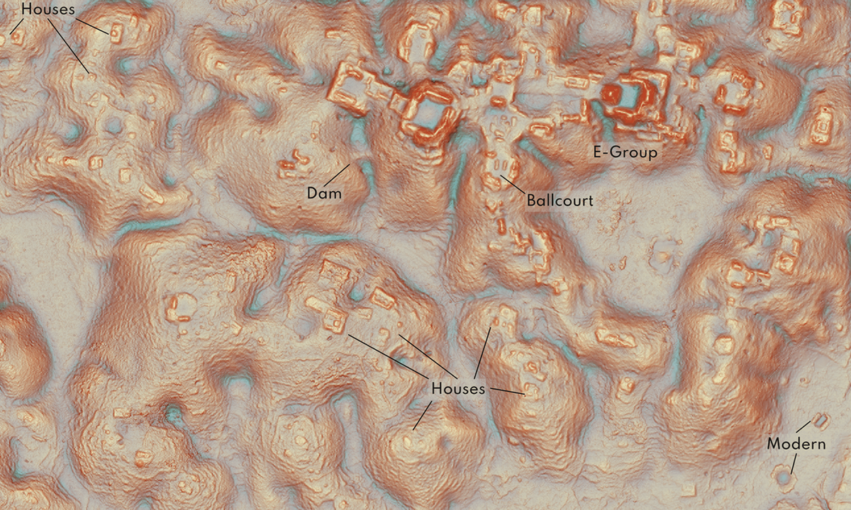
One of the survey blocks landed directly on Valeriana. The mapped portion held two major concentrations of monumental architecture about two kilometers apart, joined by dense settlement and modifications to the surrounding landscape, and archaeological features and agricultural infrastructure filled the 16.6-square-kilometer survey block. The city itself appeared to continue past the area covered by the lidar data.
The larger monumental precinct contained enclosed plazas linked by a broad causeway, temple pyramids, a ballcourt and a reservoir created by damming a seasonal watercourse.
Researchers also identified a probable E-Group architectural complex, a form that they said generally indicates a founding date before AD 150. Valeriana therefore looked, in the authors’ words, like a place with the architectural characteristics of a Classic Maya political capital.
The Surprise Was How Ordinary the Density Looked
The greatest visibility was caused by discovering a significant number of residents within a city that is buried under forest cover. However, the greater finding is that when you compare Valeriana and the rest of the settlement to other areas surveyed by archaeologists as part of their research projects, we have discovered that there are many similar findings.
The total dataset included 6,764 total structures that were mapped. The researchers report an average of 55.3 structures per square km.
Densities changed dramatically from one location to another. On one block it went from nearly nothing (empty space) to 195 structures per square km. Valeriana’s block has an estimated 426 structures/km^2; this was a higher density gradient than all but one of the team’s comparison sites (Calakmul).
This difference makes sense.

On the third survey block the researchers found scattered residences, minimal monumental architecture and very little investment in water storage. The three blocks represented a low-density rural area, a more populated rural or periurban landscape and a large, dense city – roughly the same types of settlements as can be found in studies done in response to specific known archaeological sites through deliberate centering.
By taking out the intentional archaeological “target” they didn’t get rid of the dense Maya settlement either.
Therefore, the researchers determined that large numbers of cities/densely inhabited regions existed throughout much of the central Maya Lowlands. Instead of proving that prior archaeological surveys greatly overestimated regional densities because those prior surveys concentrated on likely high-density locations, the environmental lidar produced consistent results.
In addition to helping explain how an obviously unknown city could exist right next to present day activity, Auld-Thomas said in interviews that Valeriana is located right along what is considered the only highway in the region, as well as nearby a community of people who have been farming around the ancient ruins.
“The government never knew about it; the scientific community never knew about it,” he said.
LIDAR Can Reveal Structures, but Not Their Full History
The maps still have limits.
At the time of publication, the researchers had not carried out field validation in the Campeche areas analyzed for the study. They also warned that natural or human-made rock piles can resemble small house mounds in lidar images, so some mapped structures may eventually be reclassified.
/https://tf-cmsv2-smithsonianmag-media.s3.amazonaws.com/filer_public/2d/5e/2d5ef66d-043b-45ff-a242-0bdd634abb67/urn_cambridgeorg_id_binary_20241029083015917-0498_s0003598x24001480_s0003598x24001480_fig5.jpeg)
At the same time, previous ground checks of Maya lidar surveys have often uncovered small structures the remote data missed. The authors therefore describe their feature counts as preliminary.
There is also a problem lidar cannot solve from the air: chronology.
A terrain model records structures visible on the landscape, but it cannot establish that every mapped building was occupied at the same time. Susan Gillespie, a University of Florida anthropologist who was not involved with the research, made the same point to the Associated Press, noting that aerial mapping alone cannot determine the size of a population at any single moment.
Enjoyed this article? Subscribe to our free newsletter for engaging stories, exclusive content, and the latest news.

