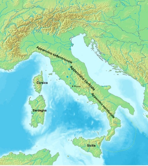
Эрдэмтэд Апеннины нурууны доорх тектоник хавтангууд хэрхэн салж, бүс нутгийн гадаргуугийн хэв гажилтыг үүсгэж буй механизмыг тайлбарлав.
Италийн Флоренцийн их сургуулийн судлаач Стефано Тавани тэргүүтэй баг Апеннины нурууны доорх гүний геологийн үйл явцыг судалж, царцдасын “цахилгаан мэт” салж буй (delamination) үзэгдлийг илрүүлжээ. Энэхүү үйл явцын үеэр дэлхийн царцдасын нягт доод давхарга болон литосфер нь дээд давхаргаасаа салж, манти руу шигдэн ордог байна. Судлаачид энэхүү салж буй хэсгийг “нугас” (hinge) гэж нэрлэсэн бөгөөд уг фронт нь газрын гүнд шилжих замаар уулархаг бүс нутгийн тектоник бүтцийг өөрчилж байгааг тогтоожээ.
Судалгааны баг газар хөдлөлтийн бүртгэл, GPS-ийн хэмжилт, хиймэл дагуулын радар болон газрын царцдас ба мантийн зааг болох Мохогийн хил хязгаарын судалгааг нэгтгэн дүгнэсэн байна. Үр дүнд нь Апеннины дагуу 500 гаруй километр үргэлжлэх бүсэд Тиррений тэнгис болон Адриатын тэнгисийн талын Мохо давхаргууд давхцаж байгааг илрүүлжээ. Энэхүү бүтцийн өвөрмөц байдал нь доод царцдас салж буйн гол нотолгоо болж байна.
Энэхүү үйл явц нь Апеннины нуруунд ажиглагддаг нэгэн зэрэг явагдах суналт ба шахалтын зөрчилтэй үзэгдлийг тайлбарлаж байна. “Нугас”-ын ард царцдас сунаж, урд талд нь шахалт үүсдэг бөгөөд GPS-ийн хэмжилтээр жилд дунджаар 4 миллиметрийн суналт, 2 миллиметрийн шахалт бүртгэгддэг аж. Ийнхүү уулын нуруу нь “баян хуур” мэт хөдөлгөөн хийж, дотоод хэсэг нь сунаж, урд тал нь богиносч байна.
Судлаачид энэхүү механизм нь 2 сая жилийн өмнөөс Тиррений тэнгисийн тэлэлт удааширсан ч Апеннины нурууны хэв гажилт үргэлжилсээр байгааг тайлбарлаж буй юм. Гэсэн хэдий ч энэхүү загвар нь хялбаршуулсан хувилбар бөгөөд газрын гүн дэх хавтангийн бүтэц, үйл явцыг бүрэн дүүрэн ойлгохын тулд нэмэлт судалгаа шаардлагатай гэдгийг эрдэмтэд тэмдэглэжээ.
Дэлгэрэнгүйг эх сурвалжаас харах
↓Эх сурвалжийг нээх ↓
Deep beneath Italy, a slow geological process is reshaping the Apennine Mountains in a way scientists did not fully understand until now. Researchers say Earth’s crust is undergoing a kind of “unzipping” process, where deeper layers peel away and create the unusual combination of stretching and compression observed across the region.
The discovery offers a new explanation for one of the most puzzling geological contradictions in the Apennines. While parts of the mountain range are being pulled apart, other areas are still being squeezed together, creating a complex pattern of deformation that has challenged geologists for years.
Stretching for around 1,200 kilometers along the Italian peninsula, the Apennines preserve a remarkable record of tectonic activity. Mountain ranges usually form when tectonic plates collide, forcing Earth’s crust to thicken and rise, but the geological history of this region has followed a far more complicated path. Different parts of the mountain system have experienced opposite movements at the same time.
For decades, scientists have tried to understand how extension and compression could coexist within the same mountain belt. Earlier explanations mainly focused on slab rollback, a process in which a sinking tectonic plate retreats into the mantle and pulls the crust behind it apart.
A Geological Puzzle Hidden Beneath The Apennines
Over millions of years, tectonic activity built the Apennines as plates pushed against each other and gradually shaped the mountain chain. Yet the forces responsible for creating the range also generated unexpected movements below the surface.
Led by Stefano Tavani of the University of Florence, the researchers identified delamination as a key process behind the current deformation. During this process, the dense lower crust and attached lithosphere separate from the upper crust before sinking into the mantle. Rather than occurring across the entire region simultaneously, the peeling appears to advance along a moving front known as a hinge.
The situation became more difficult to explain after changes that occurred around 2 million years ago. The extension that contributed to the opening of the Tyrrhenian Sea slowed significantly, but deformation within the Apennines continued. Scientists therefore looked for another mechanism capable of driving the ongoing changes beneath the mountain range.
The researchers suggest that the gradual removal of deeper crustal material provides the missing explanation for the contradictory movements visible at the surface.
Scientists Trace The “Unzipping” Process Deep Underground
To reveal what was happening below Italy, Tavani and his colleagues combined several decades of geological observations. Their work brought together earthquake records, GPS measurements, satellite radar observations and investigations of the boundary separating Earth’s crust from the mantle, known as the Moho.

According to Communications Earth & Environment report, researchers detected a zone extending for more than 500 kilometers along the Apennines where the Moho beneath the Tyrrhenian side overlaps with the Moho beneath the Adriatic side. They interpret this unusual structure as evidence that the lower crust is peeling away beneath the mountain range.
The seismic data also revealed a transition across the region. Behind the migrating hinge, earthquakes mainly show that the crust is being stretched, while ahead of it, they indicate compression. GPS measurements match this pattern, showing about 4 millimeters per year of extension across the mountain belt and roughly 2 millimeters per year of contraction near its outer edge.
This combination of opposite movements gives the mountain range an “accordion-like” behavior, as the interior stretches while the front continues to shorten.
A New View Of How Mountains Change Over Time
By studying the movement of the delamination hinge, scientists now have a different explanation for the present-day evolution of the Apennines. The process suggests that the mountain range is not shaped by a single force but by changing interactions between the crust, mantle and sinking rock layers beneath the surface.
Ahead of the hinge, the lower crust and lithospheric mantle remain connected to the descending slab, which pulls the crust downward. As the peeling front moves forward and those dense layers separate, the pressure decreases. The remaining crust can then rise as heavier material is replaced by more buoyant mantle.
According to the researchers, this mechanism explains why extension occurs behind the hinge while compression continues ahead of it. However, they also acknowledge that the model remains simplified and that the exact structure of the slab beneath the Apennines requires further investigation.

The study describes the Apennines as a rare example of a mountain system where scientists can track a migrating delamination process linked to ongoing geological change. It shows that even landscapes that appear stable on human timescales are still being transformed by deep forces operating beneath Earth’s surface.
Enjoyed this article? Subscribe to our free newsletter for engaging stories, exclusive content, and the latest news.

