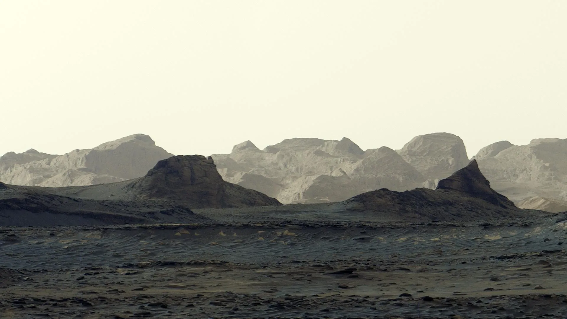
NASA-гийн Curiosity ровер Ангараг гарагийн гадаргуу дээрх салхинд элэгдсэн өвөрмөц хадны тогтоцын шинэ панорама зургийг илгээж, эрдэмтдийн анхаарлыг татаж байна.
Ангараг гарагийн 4,982 дахь өдөр буюу наймдугаар сарын 11-нд авсан энэхүү зураг нь Шарп уулын баруун хойд хэсэгт орших “ярданг” буюу салхины үйлчлэлээр үүссэн хадны тогтоцыг тод харуулжээ. Curiosity роверын Mastcam төхөөрөмжөөр авсан зургаан тусдаа гэрэл зургийг нэгтгэн бүтээсэн энэ панорама нь Ангараг гарагийн өглөөний байгалийн өнгө, гэрэлтүүлгийг өөрчлөлтгүйгээр хадгалсан байна.
Шарп уул нь 2014 оноос хойш Curiosity-гийн судалж буй 5 км өндөр уул бөгөөд тус ровер саяхан 1 км-ийн өндөрт авирч, Ангараг гараг дээрх хамгийн өндөр авиралтыг хийсэн амжилтыг тогтоожээ. Уг хадны тогтоц нь ойролцоогоор 16 км үргэлжлэх бөгөөд эрдэмтэд эдгээр чулуулгийг ойроос судлах нь тус бүс нутгийн газарзүйн хөгжлийг тайлбарлахад тусална гэж үзэж байна.
Шарп уулын тунамал чулуулгийн давхаргууд нь Ангараг гараг дээр олон тэрбум жилийн өмнө нуур, гол мөрөн оршин байсныг гэрчилдэг. Гэвч уг ярданг давхаргын өнгө, чулуулгийн налуу өнцөг нь эргэн тойрныхоо газраас ялгаатай байгаа нь зөвхөн салхины элэгдлээс гадна галт уулын үнс нурам зэрэг өөр хүчин зүйлээс үүссэн байж болзошгүй гэсэн таамаглалыг төрүүлж байна.
NASA-гийн төслийн эрдэмтэн Ашвин Васавадагийн тэмдэглэснээр, энэхүү давхаргын үүсэл нь тодорхойгүй байгаа нь түүнийг судлах сонирхлыг улам нэмэгдүүлж байна. Curiosity ровер 2027 онд уг хадны тогтоцын доод хэсэгт хүрч, робот гарны тусламжтайгаар нарийвчилсан хэмжилт хийхээр төлөвлөж байгаа бөгөөд энэ нь Ангараг гарагийн эртний байгаль орчны өөрчлөлтийн талаарх чухал мэдээллийг өгөх юм.
Дэлгэрэнгүйг эх сурвалжаас харах
↓Эх сурвалжийг нээх ↓
NASA’s Curiosity rover has captured a spectacular new panorama of Mars, providing its clearest look yet at a series of mysterious cliffs shaped by wind. Scientists have been eager to examine these distant formations up close, and the latest images offer an exciting preview of what lies ahead. Taken at 8:30 a.m. local Mars time, the scene reveals striking blue tones across the foreground while morning sunlight illuminates rugged cliffs known as yardangs along the horizon.
Curiosity recorded the panorama using its Mastcam on August 11, during the mission’s 4,982nd Martian day, or sol. Six separate photographs were transmitted to Earth and combined to create the sweeping view. Unlike most Mastcam photographs, the images were processed without white balancing, allowing the scene to retain the distinctive colors and lighting of the Martian morning.
Curiosity Approaches Mysterious Martian Cliffs
The yardangs stretch approximately 10 miles (16 kilometers) across the northwestern portion of Mount Sharp, a 3-mile-tall (5-kilometer-tall) mountain that Curiosity has been climbing since 2014. The rover recently achieved a major milestone, gaining 0.6 miles (1 kilometer) in elevation, a greater climb than any other rover has completed on Mars.
As Curiosity continues toward these unusual formations, researchers anticipate increasingly detailed views of the cliffs. More importantly, they hope that examining the rocks firsthand will help explain how the remarkable landscape developed.
What Mars’ Ancient Rocks Reveal About Its Past
Mount Sharp contains numerous layers of sedimentary rock, each preserving evidence from a different chapter of Martian history. Investigating these layers has helped scientists reconstruct a time billions of years ago when lakes and streams existed in this region of Mars.
As the planet’s environment changed, those bodies of water eventually disappeared, leaving deposits of salty minerals behind. Once additional material stopped accumulating on the mountain, powerful winds may have gradually eroded portions of the existing rock, carving out the distinctive yardangs visible today.
Yet the unusual appearance of this particular layer has raised questions about its origins. Its color differs from the surrounding terrain, and its rock layers are tilted in an unexpected direction. Scientists suspect that processes beyond ordinary wind erosion may have contributed to its formation.
“The yardang layer looks out of place. It’s the wrong color, the layers tilt at an odd angle, and it almost appears plastered on,” said Ashwin Vasavada, Curiosity project scientist of NASA’s Jet Propulsion Laboratory in Southern California. “But that’s what makes it exciting to reach. No one is sure exactly what created this layer, but one idea is it may be ash deposited by ancient volcanic eruptions.”
NASA Plans to Investigate the Cliffs in 2027
Curiosity is now in the second year of its fifth extended mission, which began with an investigation of unusual spiderweb-like boxwork ridges. Over roughly the next year, the rover will continue traveling through rock layers containing abundant sulfates and carbonates, minerals that provide evidence of ancient drying conditions on Mars.
Mission scientists aim to reach the bottom of the yardang formations sometime in 2027. Once there, Curiosity should be able to examine the mysterious cliffs using its robotic arm, gathering unique measurements that could help determine how they formed and reveal more about the environmental changes that shaped Mars billions of years ago.