Европын хамгийн том энэхүү хүлэрлэг намгархаг экосистем нь асар их хэмжээний нүүрстөрөгчийг хадгалах чадвартай, дэлхийн уур амьсгалын өөрчлөлтийг сааруулахад чухал үүрэгтэй газар нутаг юм.
Шотландын хойд хэсэгт орших “Flow Country” хэмээх намгархаг газар нь гаднаасаа энгийн мэт боловч экосистемийн хувьд нэн онцгой бүс нутаг юм. Энэхүү газар нутаг нь хүлэрлэг хөрсөн дор асар их хэмжээний нүүрстөрөгчийг олон мянган жилийн турш хадгалсаар ирсэн байна. Тус бүс нутаг нь хүлэрлэг намгархаг газрын анхны тохиолдол болон ЮНЕСКО-гийн Дэлхийн өвийн жагсаалтад бүртгэгдсэн нь байгаль хамгааллын хувьд түүхэн үйл явдал боллоо.
Энэхүү экосистем нь хур тунадас ихтэй, ус зайлуулах суваг муутай, ууршилт багатай газруудад бүрэлдэн тогтдог. Дэлхийн хуурай газрын ердөө 0.1 хүрэхгүй хувийг эзэлдэг хэдий ч дэлхийн нийт хүлэрлэг газрууд нь дэлхийн бүх ойн нөөцөөс хоёр дахин их буюу 600 гигатонн нүүрстөрөгчийг өөртөө шингээсэн байдаг гэж эрдэмтэд тооцоолжээ. Шотландын Хайлендс бүсэд орших 1,900 ам дөрвөлжин км талбай бүхий энэ газарт 9,000 гаруй жилийн турш хүлэр хуримтлагдаж, зарим хэсэгтээ найман метрээс дээш зузаан давхарга үүсгэсэн байна.
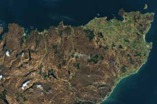
NASA-гийн Landsat 8 хиймэл дагуулын авсан зурагт тус бүс нутгийн намгархаг газруудыг хар хүрэн өнгөөр, харин баруун талын тариалангийн талбайг цайвар ногоон өнгөөр ялган харуулжээ. Төв хэсэгт байрлах хар ногоон өнгийн геометрийн хэв маяг нь шилмүүст ойн тарималжуулсан талбайг илтгэдэг. Эрдэмтдийн онцолсноор, ой мод нь нүүрстөрөгчийг амьд модонд хуримтлуулж, шатах эсвэл үхэх үедээ агаар мандалд буцаан алддаг бол хүлэрлэг намгархаг газар нь уг нүүрстөрөгчийг хэдэн мянган жилийн турш тогтвортой хадгалдаг онцлогтой юм.
Дэлгэрэнгүйг эх сурвалжаас харах
Эх сурвалжийг нээх ↓
Compared to ecosystems in many other parts of the world, the blanket bogs of the Flow Country in northern Scotland are unassuming—soggy, treeless landscapes dominated by hummocky mosses, grasses, and heathers. Yet, to ecologists, the seemingly desolate areas are nothing short of extraordinary.
The bogs store tremendous quantities of carbon. That’s because their soils are so waterlogged that microbes cannot fully break down dead plant material, a process that would otherwise release carbon dioxide. Instead, partially decayed plant matter accumulates into thick layers of spongy, crumbly, carbon-rich material called peat.
The unusual ecosystems, also called blanket mires and featherbed bogs, only occur in places with abundant rainfall, poor drainage, and low levels of evapotranspiration. These types of bogs cover just 120,000 square kilometers (46,000 square miles) globally, less than one-tenth of one percent of Earth’s land surface. The image above, captured by the OLI (Operational Land Imager) on Landsat 8, is centered on blanket bogs in the Scottish Highlands, home to the largest such ecosystem in Europe. This peatland is also the first of its type to be inscribed as a UNESCO World Heritage Site.
The peat bogs of northern Scotland, home to more than 30 species of sphagnum moss, are spread across some 1,900 square kilometers (730 square miles) of the country’s Highlands region. In this image, boggy areas appear dark brown and are sprinkled with lakes. The light green area on the right side around Thurso is farmland. The darker green geometric patterns in the center are conifer plantations. The image was captured in the spring, the part of the year when the land surface is most waterlogged and peat bogs begin to accumulate large amounts of new biomass.
While forests store most of their carbon in living trees—which eventually release it back into the atmosphere when they burn or die—peat bogs often store carbon for many thousands of years. Some parts of the Flow Country have been accumulating peat for more than 9,000 years, building deposits exceeding eight meters thick, according to UNESCO. Overall, scientists estimate that all of the world’s peatlands cover just 3 percent of Earth’s land surface but store more than 600 gigatons of carbon—about twice as much as all the world’s forests combined.
NASA Earth Observatory images by Michala Garrison, using Landsat data from theU.S. Geological Survey. Story by Adam Voiland.
References & Resources
- Aitkenhead, M.J. (2016) Mapping peat in Scotland with remote sensing and site characteristics. European Journal of Soil Science, 68(1), 28-38.
- BBC (2020, August 3) Scotland’s 10,000-year-old wild heartland. Accessed November 10, 2026.
- The Flow Country Partnership, The Flow Country. Accessed November 10, 2026.
- Lindsay, R. & Anderson, R. (2016) Blanket Mires of Caithness and Sutherland, Scotland’s Great Flow Country (UK). The Wetland Book. (Springer: Dordrecht).
- Michigan Tech (2019) Peatlands cover 3 percent of land and store 30 percent of soil carbon. Accessed November 10, 2026.
- NatureScot (2024, July 26) Scotland’s The Flow Country secures World Heritage Site status. Accessed November 10, 2026.
- NatureScot (2026, August 27) Blanket bog. Accessed November 10, 2026.
- Warren, C. (2008) Birds, bogs and forestry’ revisited: The significance of the flow country controversy. Scottish Geographical Journal, 116(4), 315-337.
You may also be interested in:
Stay up-to-date with the latest content from NASA as we explore the universe and discover more about our home planet.
3 min read
Brown carbon, emitted by wildland fires and tracked over the span of a week in July 2026, worsened air quality…
3 min read
Fall color covers the forested slopes of Bieszczady National Park, while patches of polonina, a type of high-mountain meadow, have…
4 min read
Over the years, astronauts aboard the International Space Station have photographed several of the cities hosting the 2026 FIFA World…