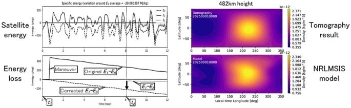
Киотогийн их сургуулийн судлаачид Starlink-ийн 1,200 орчим хиймэл дагуулын орбитын мэдээллийг ашиглан дэлхийн гадаргуугаас 500 орчим километр өндөрт орших агаар мандлын нягтыг тодорхойлох шинэ аргыг боловсрууллаа.
Дэлхийн нам орбитод асар олон тооны хиймэл дагуул болон сансрын хог хаягдал эргэлдэж байгаа нь тэдгээрийн хөдөлгөөнд агаар мандлын таталцал нөлөөлөх шалтгаан болдог. Ялангуяа 100-1,000 километр өндөрт орших термосфер давхарга нь 99 гаруй хувь нь цахилгаан цэнэггүй хийгээс бүрддэг тул ажиглалт хийхэд нэн хүндрэлтэй байдаг. Судлаачид тус бүсэд байрлах Starlink хиймэл дагуулуудын орбитын өөрчлөлт болон агаар мандлын чирэгдэл (drag)-ийг шинжлэх замаар нягтын хэмжилтийг хийсэн байна.
Анагаах ухааны дүрслэлд ашигладаг томографийн аргыг сансрын шинжлэх ухаанд нэвтрүүлснээр дэлхийн агаар мандлын нягтын хоёр хэмжээст зураглалыг гаргаж авчээ. Энэхүү судалгааны үр дүн нь ESA-гийн SWARM хиймэл дагуулын ажиглалттай нийцэж байгаа нь уг аргын нарийвчлалыг баталж байна.
Судалгааны багийн ахлагч Мамору Ямамотогийн тэмдэглэснээр, энэхүү ажил нь сансрын шинжлэх ухаан болон инженерийн салбар хоорондын уялдаа холбоог бэхжүүлж байна. Агаар мандлын нягтын нарийвчилсан хэмжилт нь хиймэл дагуулуудын хөдөлгөөнийг урьдчилан таамаглах, сансрын мөргөлдөөнөөс урьдчилан сэргийлэхэд чухал ач холбогдолтой юм. Цаашид энэхүү аргыг бодит цагийн горимд ашигласнаар сансрын цаг агаарын урьдчилсан мэдээг сайжруулж, хиймэл дагуулын ажиллагааны аюулгүй байдлыг хангах боломжтой гэж үзэж байна.
Дэлгэрэнгүйг эх сурвалжаас харах
↓Эх сурвалжийг нээх ↓
Scientists have used orbital information from roughly 1,200 Starlink satellites to reconstruct atmospheric density nearly 500 kilometers above Earth. The technique provides a new way to visualize the difficult-to-observe thermosphere and could provide useful information for tracking objects in increasingly crowded orbits.
Thousands of satellites and pieces of space debris now travel through low Earth orbit, where even the faint traces of Earth’s atmosphere can affect their motion. At altitudes of several hundred kilometers, atmospheric drag gradually slows satellites, making accurate measurements of density relevant to predicting their trajectories and assessing collision risks.
The problem is that this region is difficult to observe. More than 99% of the upper atmosphere consists of electrically neutral gas, while ionized gas in the ionosphere represents less than 1%. Because ionized particles influence radio-wave propagation, the ionosphere is comparatively straightforward to monitor. Measuring the neutral atmosphere of the thermosphere, extending roughly from 100 to 1,000 kilometers above Earth, presents a tougher challenge.
Starlink Becomes a Science Tool
Researchers at Kyoto University approached that observational problem by using satellites already moving through the thermosphere. Data reported by the university show that the scientists analyzed publicly available orbital information from approximately 1,200 Starlink satellites flying at an altitude of 482 kilometers. Their method relies on atmospheric drag and the gradual decay of satellite orbits. By examining those orbital changes, the team estimated the thermospheric density surrounding the spacecraft.
The researchers combined these measurements through tomography, a method best known for its use in medical imaging. Instead of looking inside the human body, the technique brought together observations from across the globe to reconstruct variations in atmospheric density.
“This is a multidisciplinary study between space science and space engineering,” corresponding author Mamoru Yamamoto said. “Reading papers from both research fields, we realized that deeper dialogue between researchers from both fields is necessary.”
A Two-Dimensional Map Adds a Geographic View
Using the Starlink measurements, the scientists produced a two-dimensional latitude-longitude snapshot of thermospheric density at an altitude of roughly 500 kilometers. The research team describes the work as the first tomographic analysis of its kind. The reconstructed density patterns also showed strong consistency with observations made by the European Space Agency’s SWARM satellites.
Those spacecraft measure variations in atmospheric density along their orbital paths, providing another observational reference for the patterns identified with the Starlink data. The technique builds on earlier research by the same group. In that work, the scientists used general orbital information known as Two-Line Element (TLE) data from Starlink satellites to estimate changes in thermospheric density over time and altitude.

The newer analysis examines another dimension of the atmosphere. By mapping variations horizontally across latitude and longitude, the researchers can reveal geographic structures in thermospheric density that were not captured in their earlier approach.
Atmospheric Density Matters in Orbit
Even at such extreme altitudes, traces of neutral atmospheric gas create enough drag to influence how satellites move. That makes accurate atmospheric-density measurements essential for operators trying to predict the future paths of objects in orbit.
The report noted that more precise atmospheric-density measurements could improve forecasts of satellite trajectories, making it easier to anticipate and avoid potential collisions with other spacecraft or space debris. That application has become increasingly relevant as the number of objects orbiting Earth continues to grow.

The research also links atmospheric science with practical space engineering. Better thermospheric measurements can provide scientists with information about an elusive part of Earth’s upper atmosphere while supplying engineers with data relevant to satellite operations.
The method could eventually support near-real-time measurements of atmospheric density around satellites. Such monitoring could improve space weather forecasting and contribute to safer and more dependable satellite operations.
Enjoyed this article? Subscribe to our free newsletter for engaging stories, exclusive content, and the latest news.