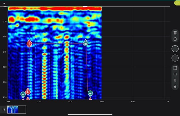
Археологичид газрын гүн дэх бүтцийг судлах дэвшилтэт технологи ашиглан Инкүүдийн эзэнт гүрний үеийн далд гарцыг зураглан тогтоов.
Археологич Хорхе Калеро Флорес болон Милдред Фернандес Паломино нар 1998 оноос хойш Куско хотын доорх “Чинкана” хэмээх далд хонгилын сүлжээг судлах ажлыг удирдаж байна. Судлаачид 1594 оны түүхэн баримтуудаас эхлэн колоничлолын үеийн бичвэрүүдэд дурдагдсан уг байгууламжийг илрүүлэхийн тулд акустик хайгуул болон газрын гүнийг нэвтрэн харах радарыг (GPR) ашиглажээ. Энэхүү технологийн тусламжтайгаар малтлага хийх шаардлагагүйгээр хонгилын бүтцийг гурван хэмжээст загвараар гаргаж авсан байна.
Судалгаагаар Нарны сүм буюу Кориканчагаас Саксайуаман археологийн цогцолбор хүртэл үргэлжлэх 1.75 км урт гол хонгил болон бусад гурван жижиг салбар хонгилыг илрүүлжээ. Ойролцоогоор 260 см өргөн, 160 см өндөр хэмжээтэй уг хонгил нь “зүсэж нөхөх” (cut-and-cover) аргаар хийгдсэн бөгөөд чулуун хана, модон дээврээр бүрсэн бүтэцтэй болохыг тогтоов. Судлаачдын үзэж буйгаар ийм хэмжээс нь тухайн үед хүмүүсийг дамнуургаар тээвэрлэх боломжтой байсныг илтгэж байна.
Энэхүү далд гарц нь хотын төв хэсгээр хойд-өмнөд чиглэлд үргэлжлэх бөгөөд газрын гадаргуу дээрх эртний инкүүдийн зам болон дэнжүүдийн системтэй давхцаж байна. Хэдийгээр археологичид хонгилын замыг амжилттай зурагласан боловч түүний үндсэн зориулалтын талаарх тайлбарыг батлах нотолгоо хараахан гараагүй байна. Цаашид уг байгууламжийн дотоод бүтцийг судлахын тулд стратегийн чухал цэгүүдэд малтлага хийх шаардлагатай байгааг судлаачид онцоллоо.
Дэлгэрэнгүйг эх сурвалжаас харах
↓Эх сурвалжийг нээх ↓
Archaeologists have located and mapped an extensive network of Inca tunnels under Cusco. The primary underground passageway stretches approximately 1750m (or 1.1 miles) between the Temple of the Sun (Coricancha), formerly the Inca capital’s ceremonial center, and the Sacsayhuaman archaeological complex.
This network of tunnels is known as the “Chincana” and has existed within written accounts for over three hundred years prior to researchers utilizing acoustic and geophysical methods to trace its path beneath modern day Cusco. Jorge Calero Flores, and Mildred Fernandez Palomino are the lead archaeologists on this project and have researched the Chincana since 1998.
This underground network consists of a main corridor running from the Coricancha to Sacsayhuaman, with three additional smaller corridors. These smaller corridors include one leading toward Callispuquio, another toward the Muyucmarca area of Sacsayhuaman, and a final corridor behind the Church of San Cristobal.
The main corridor under consideration is approximately 1.75 kilometers long and is located along a north-south axis through central Cusco, corresponding with parts of the ancient Inca road and terracing system at the surface. The length of this corridor was determined by the team and reported as 1750m in their most recent presentation.
The size of the underground corridor is estimated to be approximately 260cm (or 8.5ft) wide x 160cm (or 5.2ft) high. According to Calero these dimensions may have permitted individuals to be transported through the tunnel via litter.
“We believe that the Incas may have traveled through there on litters,” Calero said.
These measurements suggest that it would be feasible for individuals to physically travel through the corridor; however, it remains unclear what the ultimate function(s) of this route was in the context of the Inca empire. The researchers provided no evidence supporting their interpretation of this finding.
Ancient Accounts Directed Initial Research Efforts
Historical accounts were utilized by researchers to initiate their search for the Chincana, rather than beginning with an excavation effort. An account describing an underground route from the Coricancha to Sacsayhuaman was documented by an anonymous Jesuit in 1594. Additionally, some colonial-era documents referencing underground routes in Cusco were also reviewed by researchers.
By comparing written accounts generated throughout the sixteenth, seventeenth, and eighteenth centuries with contemporary observations of Cusco’s layout, researchers identified potential locations for accessing the underground route. Specifically, based upon historical accounts, researchers believed they could potentially begin searching in the Rodadero sector near Sacsayhuaman.
To further narrow down potential locations where the underground route may exist, researchers utilized acoustic prospecting techniques to identify voids or cavities beneath the surface. Once potential locations were identified using acoustic prospecting, researchers used ground-penetrating radar (GPR) to collect additional data regarding the subsurface structure of each location.

GPR collects information regarding subsurface structures and voids by transmitting pulses of electromagnetic energy into the earth and measuring changes in signal strength caused by variations in buried material properties. Researchers analyzed GPR collected data and produced three-dimensional representations of buried structures.
Together, the results of acoustic prospection and GPR collected data provided researchers with sufficient information to map a route through Cusco without requiring continuous excavation efforts between Coricancha and Sacsayhuaman.
Construction Methods Used in Building the Chincana
The research suggests that the tunnels and passages were constructed through a method called cut-and-cover construction.
According to researchers, Inca builders dug a trench, then lined each side of the trench with stone walls, installed a roof consisting of wooden beam roofing elements, and finally covered the structure. Roadways, streets, and/or terracing systems were constructed above portions of the underground route.
As such, the mapped route reflects this pattern of construction in many respects. Portions of the route lie beneath the primary Inca street that previously connected Sacsayhuaman and Coricancha, while other segments run beneath existing terracing systems.

Additionally, the Inca engineering described in the survey corresponded with descriptions contained in historical texts referenced during the course of this study. For example, Garcilaso de la Vega cited in the Peruvian report mentioned underground vaults connecting towers at Sacsayhuaman.
Results were communicated using radargrams, maps, and three-dimensional models illustrating the positioning and shape of structures detected beneath both areas.
Survey Work Precedes Excavation
While researchers have successfully mapped the underground route using non-invasive archaeological survey techniques, they have not yet explored the main passage. Physical excavation will be necessary at select points to gain entry to the underground structure according to Fernandez:
“Now we need to dig at strategic points so we can go inside,” Fernandez said.
Once excavation is completed at specific locations along the mapped route, researchers plan to explore the structure.
Enjoyed this article? Subscribe to our free newsletter for engaging stories, exclusive content, and the latest news.


Өө, Инкүүдийн хонгилын талаар уншаад их сонирхолтой санагдлаа! Тэр хонгил яагаад ингэж нуугдаж байв гэж бодож байна, түүхийн ямар нууцыг илрүүлэх гээд байж болох юм бол? Мэдээний зургийг харахаар бас хэчнээн их нууц хадгалагдаж байгааг бодохоор сонирхол нэмэгддэг шүү!