Хур тунадасны хэмжээ эрс багассаны улмаас тус улсын усны нөөц хомсдож, хөдөө аж ахуйн салбарт хүндрэл үүсээд байна.
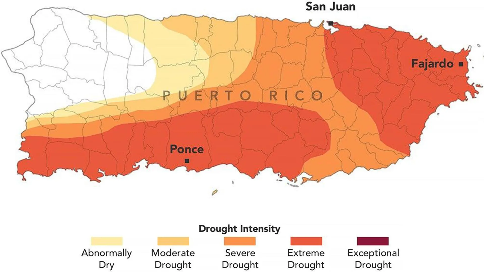
2026 оны наймдугаар сарын 25-ны өдрийн байдлаар Пуэрто-Рикогийн нутаг дэвсгэрийн 44 хувьд хэт ган гачгийн нөхцөл байдал үүсээд байгааг U.S. Drought Monitor-ын тайланд дурджээ. Тус улсын нийт нутгийн дөрөвний гурав нь дунд зэргийн ган гачигт өртөөд байгаа бөгөөд энэ нь ердөө гурван сарын өмнө ган гачиггүй байсан нөхцөл байдалтай харьцуулахад огцом өөрчлөлт юм.
Энэхүү ган гачиг нь тавдугаар сараас долдугаар сарын дунд үе хүртэл хур тунадасны хэмжээ ердийнхөөс 60 хувиар, зарим өмнөд болон баруун өмнөд бүсэд 20 хувиас доош буурсантай холбоотой байна. Үүний зэрэгцээ агаарын температур эрс нэмэгдэж, Рио Фахардо гол зэрэг усны эх үүсвэрүүдийн түвшин түүхэн доод хэмжээнд хүртэл буурчээ.
NASA-гийн судлаачид сансрын хиймэл дагуулын хөрсний чийгшлийн тооцоолол, газар дээрх цаг уурын хэмжилт болон урсцын мэдээлэлд үндэслэн энэхүү үнэлгээг гаргасан байна. Дэвид Мокко болон Жонатан Кэйс тэргүүтэй эрдэмтэд ган гачгийн долоо хоног тутмын хяналтын зураглалыг боловсруулахад оролцож байгаа анхны NASA-гийн мэргэжилтнүүд юм.
Усны нөөцийн хомсдол нь оршин суугчдын амьдрал, хөдөө аж ахуй, мал аж ахуйн салбарт сөргөөр нөлөөлж байна. Тухайлбал, жимс, какао, кофе болон гадил жимсний тариалангийн ургац алдагдаж, малчдын өвс тэжээлийн нөөц багассанаас улбаалан эрх баригчид гамшгийн нөхцөл байдал зарлаж, усны хязгаарлалт тогтоогоод байна.
Дэлгэрэнгүйг эх сурвалжаас харах
↓Эх сурвалжийг нээх ↓
Puerto Rico typically enters its wet season in May, but 2026 has unfolded very differently. By late August, rainfall had remained scarce across much of the U.S. territory, allowing drought conditions to spread rapidly. The lack of rain has contributed to water shortages and rationing in some communities, prompting Puerto Rico’s governor to declare a state of emergency in late July. In late August, the U.S. government also issued a drought disaster declaration covering more than two dozen cities and towns.
The map shows the severity and geographic extent of drought across Puerto Rico on August 25, 2026. It was created by the U.S. Drought Monitor, a collaboration involving the National Drought Mitigation Center at the University of Nebraska-Lincoln, the U.S. Department of Agriculture (USDA), the National Oceanic and Atmospheric Administration, and NASA.
NASA has supported the project for years with Earth observations and scientific expertise. That involvement expanded in 2026 when two NASA scientists joined the small group responsible for producing the weekly drought assessments.
David Mocko, a senior research scientist in the Hydrological Sciences Laboratory at NASA’s Goddard Space Flight Center, said the effects of the unusually hot and dry conditions were visible across multiple types of satellite and ground-based data used by the U.S. Drought Monitor.
For recent Puerto Rico updates, particularly important information included satellite estimates of soil moisture, along with weather measurements and observations of streamflow and well conditions, Mocko said.
Mocko prepared the U.S. Drought Monitor update for August 18, 2026. He and Jonathan Case of NASA’s Marshall Space Flight Center are the first NASA scientists to produce the weekly maps.
Extreme Drought Covers 44 Percent of the Territory
By August 25, 2026, about three-quarters of Puerto Rico was experiencing at least moderate drought, according to the assessment. Extreme drought zones (dark orange) in eastern and southwestern parts of the main island had expanded during the previous week and covered 44 percent of the territory.
The change happened quickly. Just three months earlier, none of Puerto Rico was classified as being in drought, and less than 20 percent of the territory was considered abnormally dry.
Late winter and early spring had actually been wetter than normal across the U.S. Caribbean, according to a National Integrated Drought Information System (NIDIS) report. Conditions then shifted sharply toward dryness.
Rainfall Falls Far Below Normal
From mid-May through mid-July, most of Puerto Rico received less than 60 percent of its normal precipitation, according to NIDIS. Southern and southwestern areas were even drier, receiving less than 20 percent of normal rainfall. That translated to a rainfall deficit of 3 to 6 inches (76 to 152 millimeters).
High temperatures made the drying worse. San Juan, for example, experienced one of its warmest Julys on record. River levels also fell sharply, with streamflow reaching record lows in waterways including the Rio Fajardo in northeastern Puerto Rico.
Water Shortages Hit Residents and Farmers
The strain on water supplies has affected residents, farmers, and ranchers across Puerto Rico. Water rationing has been in effect in several municipalities since early August, according to news reports. Observers have also pointed to infrastructure issues as a factor worsening the shortages.
The drought has also created serious challenges for agriculture. For farmers, dry soils have disrupted the growth of fruit and cacao trees as well as banana and coffee plants, contributing to crop losses. Ranchers, meanwhile, are seeing their hay supplies dwindle.
Drought Maps Help Guide Emergency Response
U.S. Drought Monitor maps have been published since 1999 and are used by federal, state, local, and tribal officials to help guide drought response decisions.
The USDA, for example, relies on the maps as part of a “fast track” process for issuing disaster designations. Those designations can help direct emergency assistance and other resources to affected communities.


Пуэрто-Рикогийн ган гачигийн нөхцөл ямар эрсдэл дагуулж болох вэ? Усны хомсдол хөдөө аж ахуй, амьдралд хэрхэн нөлөөлж байгааг анхааралтай ажиглаж байна. Та ийм байдалд ямар арга хэмжээ авахыг зөвлөж байна вэ?