Намрын сэрүүн өдрүүдэд Аппалачийн тэгш өндөрлөг болон Камберленд мөрний хөндийг бүрхэх нам дор үүл буюу манангийн үзэгдлийг NASA-гийн хиймэл дагуулууд бүртгэн авчээ.
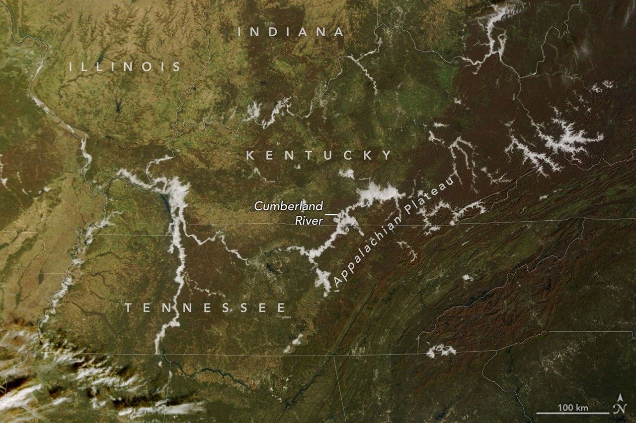
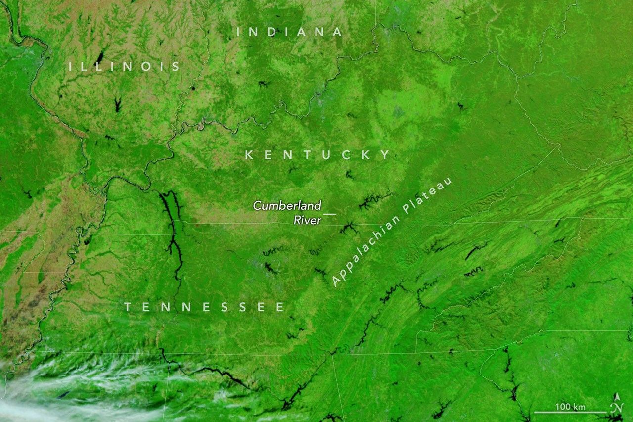
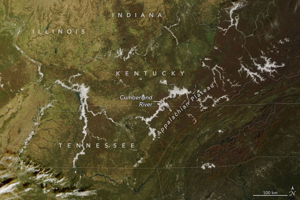
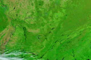
2026 оны 11 дүгээр сарын 8-ны өдөр Аппалачийн тэгш өндөрлөгийн салаалсан хөндийнүүдийг нам дор үүл бүрхсэн нь NASA-гийн Terra хиймэл дагуулын MODIS төхөөрөмжийн зурагт цагаан өнгөөр тодрон харагдаж байна. Тухайн үед уулархаг бүс нутгийн ургамалжилт хүрэн болон ногоон өнгөтэй байсан юм. Үдээс хойш гэхэд манан сарнин арилж, гол мөрөн, нуурууд ил гарч ирснийг NOAA-21 хиймэл дагуулын VIIRS төхөөрөмж хуурамч өнгөт зургаар баримтжуулжээ. Энэхүү дүрслэл нь усны нөөцийг (хар хөх) ургамалжилтаас (тод ногоон) ялгаж харахад илүү хялбар болгосон байна.
Манан нь газрын гадаргад ойр үүсдэг үүлний нэг төрөл юм. Намрын урт шөнөөр газрын хөрс өдрийн турш хуримтлуулсан дулаанаа алдаж, түүний дээрх агаарын температур шүүдэр цэгийн хэмд хүрснээр агаар ханаж, усны уур бяцхан дусал болон хувирдаг байна.
Хүйтэн агаар нь дулаан агаараас илүү нягт байдаг тул уруудан урсаж хөндийд хуримтлагддаг нь манан үүсэх үндсэн шалтгаан болдог. Кентакки, Баруун Виржиниа, Теннесси муж улсын нутаг дэвсгэрт орших гол мөрний сав газруудад чийгшил ихтэй тул ийм үзэгдэл элбэг тохиолддог байна. Үндэсний цаг уурын албаны мэдээлснээр, 11 дүгээр сарын 8-ны өглөө олон газарт температур Фаренгейтийн 30-аад градус (ойролцоогоор 0°C орчим) хүрч буурсны улмаас хөндийд өтгөн манан үүсэж, замын хөдөлгөөнд хүндрэл учруулсан байна.
Дэлгэрэнгүйг эх сурвалжаас харах
Эх сурвалжийг нээх ↓
morning
afternoon
morning
afternoon
On November 8, 2026, low clouds traced the branching valleys of the Appalachian Plateau and the Cumberland River in the morning (left, natural color) then burned off by afternoon (right, false color). The images were acquired with the MODIS(Moderate Resolution Imaging Spectroradiometer) on NASA’sTerrasatellite and the VIIRS(Visible Infrared Imaging Radiometer Suite) on NOAA-21, respectively. NASA Earth Observatory images by Lauren Dauphin.
On a cool November morning, low clouds traced the branching valleys of the Appalachian Plateau and the Cumberland River. By afternoon, they had faded, leaving clear skies over the autumn landscape.
The change is visible in this pair of images from November 8, 2026. The MODIS(Moderate Resolution Imaging Spectroradiometer) on NASA’sTerrasatellite acquired the left image that morning. In this natural-color view, low clouds appear white as they fill many of the valleys. Autumn vegetation appears in shades of brown and green.
The VIIRS(Visible Infrared Imaging Radiometer Suite) on NOAA-21 acquired the right image that afternoon, after the clouds had dissipated and exposed the rivers and lakes beneath them. This false-color view makes it easier to distinguish water (dark blue) from vegetation (bright green).
The clouds appear to be fog, a type of cloud that forms near the ground. Foggy mornings in the region are common this time of year. As nights lengthen, the ground has more time to radiate away the day’s heat, and the air just above it cools to the dew point—the temperature at which air becomes saturated and water vapor begins condensing into the tiny droplets that make up fog.
Because cold air is denser than warm air, it flows downslope and pools in valleys, so fog tends to form there first. Notice the fog filling the branching valleys across part of the Appalachian Plateau in eastern Kentucky and southwestern West Virginia. Rivers and streams that run along many of the valley floors add to the effect by supplying extra moisture. The same pattern is visible along the Cumberland River and its reservoirs in north-central Tennessee and south-central Kentucky.
According to the National Weather Service, temperatures in many places on the morning of November 8 dipped into the 30s Fahrenheit before giving way to a mild, sunny afternoon. Forecasters reported locally dense valley fog that morning. Dense fog had also blanketed a wider part of the region earlier in the week, prompting advisories for hazardous travel conditions.
NASA Earth Observatory images by Lauren Dauphin, using MODIS data from NASA EOSDIS LANCE and GIBS/Worldview, and VIIRS data from NASA EOSDIS LANCE, GIBS/Worldview and the Joint Polar Satellite System (JPSS). Story by Kathryn Hansen.
References & Resources
- NASA Earth Observatory (2018, October 26) It‘s Valley Fog Season. Accessed November 9, 2026.
- National Park Service (2024, December 10) Appalachian Plateaus Province. Accessed November 9, 2026.
- National Weather Service (2023) Weather in Action: Valley Fog. Accessed November 9, 2026.
- NOAA (2025, September 2) What‘s the Difference Between Fog and Clouds? Accessed November 9, 2026.
You may also be interested in:
Stay up-to-date with the latest content from NASA as we explore the universe and discover more about our home planet.