Сансрын хиймэл дагуулын мэдээлэлд үндэслэн хийсэн шинэ судалгаагаар дэлхийн мангр ой моддын талбай 2010 оноос хойш санаанд оромгүй байдлаар нэмэгдэж, нөхөн сэргэж эхэлснийг тогтоожээ.
1970-аад оноос хойш Landsat хиймэл дагуулын тусламжтайгаар мангр ой моддыг ажиглаж ирсэн бөгөөд олон арван жилийн турш эдгээр экосистем тасралтгүй хорогдож байв. Гэвч “Science” сэтгүүлд нийтлэгдсэн судалгаанаас үзэхэд, 1984-2010 оны хооронд 3000 орчим хавтгай дөрвөлжин км талбайг алдсаны дараа 2010 оноос хойш 2000 орчим хавтгай дөрвөлжин км талбайгаар нэмэгджээ. Ой модны энэхүү сэргэлт нь Ази, Австрали, Өмнөд Америк тивүүдэд илүү тод ажиглагдсан байна.
Тулейн их сургуулийн байгаль орчны судлаач Жен Жан (Zhen Zhang)-ийн тайлбарласнаар, энэхүү өсөлтийн гуравны хоёр нь мангр мод шинэ газар нутаг руу тархан ургасантай, үлдсэн хэсэг нь доройтсон газруудад нөхөн сэргээлт хийсэнтэй холбоотой ажээ. Ялангуяа Зүүн өмнөд Ази, тэр дундаа Мьянмар улсад 2004 оны Энэтхэгийн далайн цунамийн дараа байгаль орчны асуудалд анхаарал хандуулж, хууль эрх зүйн хамгаалалтыг чангатгасны үр дүнд мангр ойн талбай 10 хувиар өссөн байна.
Мангр мод нь дунджаар 13 метр өндөр боловч экосистемийн хувьд асар их ач холбогдолтой юм. Эдгээр ой нь халуун орны бусад ойгоос дөрөв дахин их нүүрстөрөгч хуримтлуулж, эргийн бүс нутгийг элэгдэл болон шуурганаас хамгаалах чухал үүрэг гүйцэтгэдэг. Түүнчлэн тэдний үндэс нь загас, хавч, сам хорхой зэрэг далайн амьтдын үржлийн гол орчин болдог байна.
Хэдийгээр дэлхий дахинд эерэг өөрчлөлт гарч байгаа ч зарим бүс нутагт, тухайлбал Нигерийн дельт болон Африкийн төв хэсэгт мангр ойн хорогдол үргэлжилсээр байна. Судлаачид мангр моддын сэргэлт нь сайшаалтай хэдий ч ойг устгах үйл ажиллагааг зогсоох, хамгааллын ажлыг тасралтгүй үргэлжлүүлэх нь нэн чухал болохыг анхааруулж байна.
Дэлгэрэнгүйг эх сурвалжаас харах
Эх сурвалжийг нээх ↓
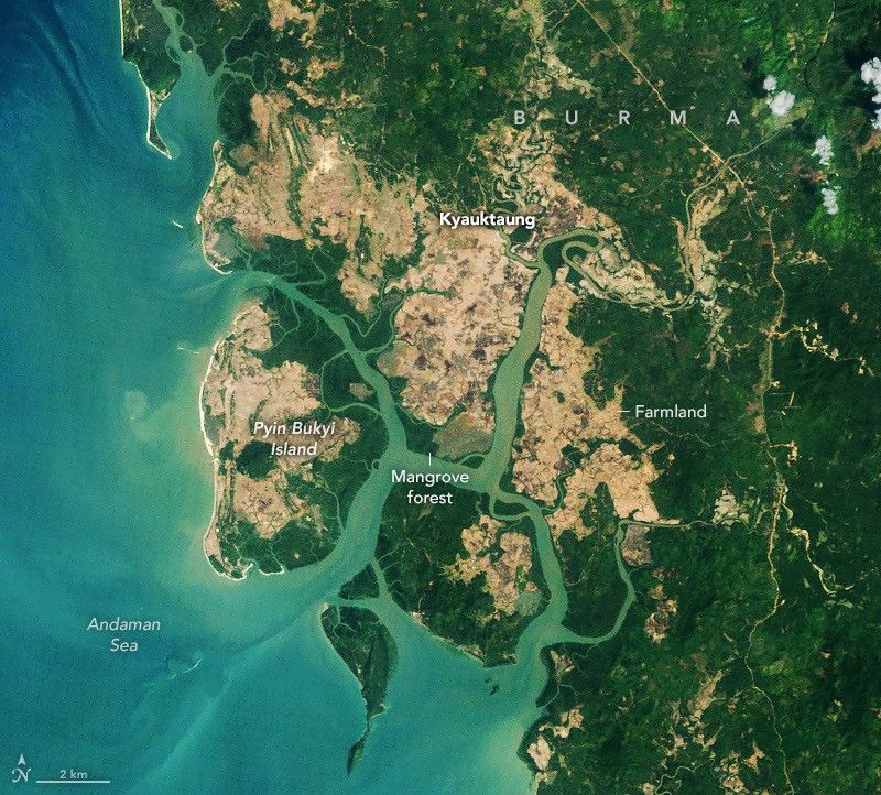
2010
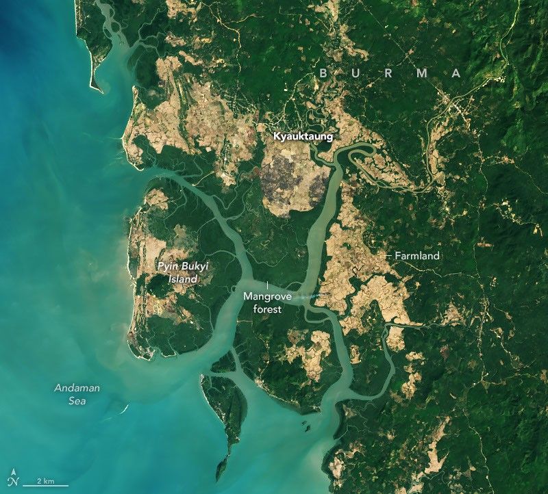
2026
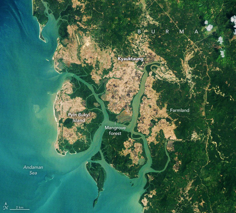
2010
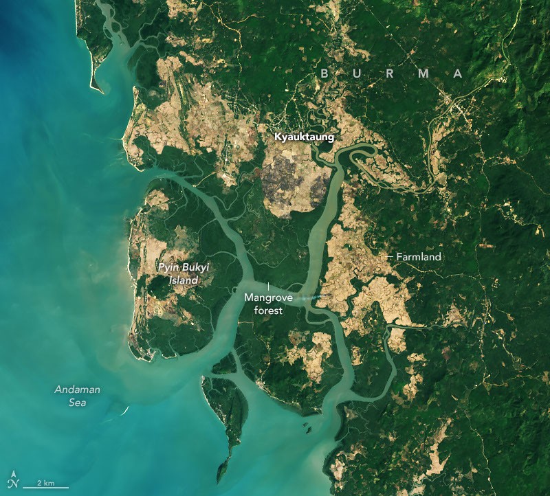
2026
Scientists began using satellites to map mangrove forests in the 1970s after the launch of the first Landsat satellite. For decades, the story they told about mangroves was dominated by loss and decline. Research published in Science suggests that the tide has turned.
A global rebound began around 2010, the scientists found, led by the expansion of mangrove forests in Asia, Australia, and South America. The researchers analyzed Landsat imagery collected between 1984 and 2023, looking for signs of changes in the extent and density of mangrove canopy.
They tallied losses of nearly 3,000 square kilometers (1,200 square miles) between 1984 and 2010, followed by an unexpected increase of nearly 2,000 square kilometers (770 square miles) of mangroves after 2010. They also found that many of today’s mangrove forests have denser, more closed canopies than they did in 2010, a sign of healthier, less degraded forests, particularly in South America.
“Other research groups have mapped and analyzed long-term changes in select regions, but these are the first global mangrove maps that cover such a long period,” said Zhen Zhang, an environmental scientist at Tulane University. “About two-thirds of the expansion was due to mangroves colonizing new areas and the other third due to restoration and regrowth in degraded areas,” he added.
One of the most notable reversals occurred in Southeast Asia—especially Burma (Myanmar). The country lost mangroves rapidly in the 1980s and 1990s due to the expansion of agriculture, aquaculture, and firewood harvesting in coastal areas, but the trend reversed around 2010, when mangrove area began expanding in many places. The authors attribute the turnaround to increased awareness and restoration efforts after the devastating Indian Ocean tsunami in 2004, strengthened legal protections for forests, and high rates of sedimentation that opened up new mudflats for colonization.
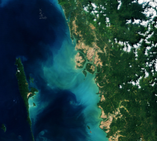
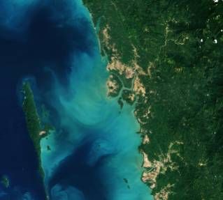
The pair of Landsat images above shows expansion of mangrove forests in Palaw Township in Burma’s Myeik District—an area that has seen both significant regeneration of degraded mangrove forests and the spread of trees into new areas since 2010. In this region, much of the regeneration appears to be occurring in abandoned rice fields (brown) south of the village of Kyauktaung. People on nearby Pyin Bukyi Island, meanwhile, have experimented with conservation projects and tree planting efforts to support mangroves. Despite the gains, deforestation remains a common challenge in Burma, which lost 28.6 percent of its mangrove area between the 1980s and 2010. Since then, the country’s mangrove area has grown about 10 percent.
Mangrove trees are relatively small—averaging about 13 meters (43 feet)—but mighty from an ecological perspective, with mangrove ecosystems storing up to four times as much carbon as taller inland tropical forests. The trees play an important role in protecting coastal communities from erosion and storm surges, and their distinctive stilt-like roots provide habitat and vital nursery grounds for fish, shrimp, crabs, and other marine life.
In several areas, such as around the mouth of the Amazon River and in northern Australia, extensive deposition of sediment has created new mudflats that mangroves have successfully colonized, contributing to steady increases in each of these regions since the 1990s. At the northern and southern edges of their range, including the southeastern U.S., warming temperatures and fewer freezes have also allowed mangroves to push into areas that were previously too cold, Zhang explained.
There are some areas, however, where losses have outweighed gains. Substantial mangrove losses in the Niger Delta, for instance, have reduced the total mangrove area in West and Central Africa since 2010. North America and southern Africa, meanwhile, have seen widespread degradation after tropical cyclones devastated broad swaths of mangroves. “The global successes we’ve seen with mangroves during the past decade should not be seen as grounds for complacency,” cautioned Zhang. “This underscores that conservation and slowing deforestation can lead to huge positive impacts when coupled with natural expansion and regeneration.”
NASA Earth Observatory images by Michala Garrison, using Landsat data from theU.S. Geological Survey. Story by Adam Voiland.
References & Resources
- Estoque, R., et al. (2018) Assessing environmental impacts and change in Myanmar’s mangrove ecosystem service value due to deforestation (2000–2014). Global Change Biology, 24(11), 5391-5410.
- Gaw, L., et al. (2018) Mangrove forest dynamics in Tanintharyi, Myanmar from 1989–2014, and the role of future economic and political developments. Singapore Journal of Tropical Geography, 39(2), 224-243.
- IUCN (2018, November 21) Sometimes, you just need to let nature take its course. Accessed November 12, 2026.
- Tulane University (2026, June 4) Global Mangrove Forests Rebound, Offering Hopeful Sign for Climate and Coastal Resilience. Accessed November 12, 2026.
- UN-REDD (2021) Myanmar Mangrove Extent Explorer. Accessed November 12, 2026.
- The Weather Channel (2026, September 7) The biggest comeback story in climate science just happened. Accessed November 12, 2026.
- Win M. & Takeda, S. (2021) Development and Abandonment of Mangrove Paddy Fields and the Impacts Thereof in a Mon Village in Taninthayi Region, Myanmar. Southeast Asian Studies, 10(3), 359-390.
- Yale Environment 360 (2026, October 22) What Is Driving the Global Resurgence of Mangrove Forests? Accessed November 12, 2026.
- Zhang, Z., et al. (2026) Unexpected expansion and regrowth in Earth’s mangrove forests over the past four decades. Science, 392(6802), 1082-1087.
You may also be interested in:
Stay up-to-date with the latest content from NASA as we explore the universe and discover more about our home planet.