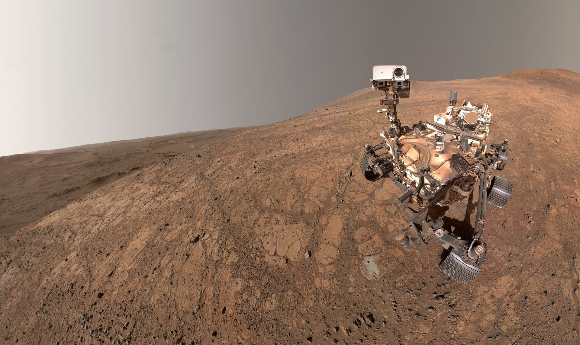
NASA-гийн Perseverance хөлөг Ангараг гаригийн эртний мөргөлдөөний ул мөрийг хадгалсан 3.9 тэрбум жилийн настай чулуулгийн давхаргыг илрүүлжээ.
NASA-гийн Perseverance ровер Ангараг гаригийн Езеро тогооны ирмэг дээр судалгаа хийж, гаригийн геологийн түүх болон гадаргыг бүрэлдүүлсэн хүчнүүдийн талаар шинэ мэдээлэл цуглуулсаар байна. Лондоны Империал коллежийн судлаачдын удирдсан баг “Journal of Geophysical Research: Planets” сэтгүүлд нийтлүүлсэн судалгаагаараа, 75 метр зузаантай, “Брүүм Пойнт” хэмээн нэрлэгдсэн чулуулгийн давхаргыг илрүүлснээ зарлав. Энэхүү бүс нутаг нь Ангараг гаригийн түүхэн дэх астероид болон сүүлчийн оддын хүчтэй мөргөлдөөнүүд элбэг тохиолдсон “Хожуу үеийн их бөмбөгдөлт” (Late Heavy Bombardment) үеийн гэрч болж байгаа юм.
Судлаачдын мэдээлснээр, Дэлхий дээр хавтангийн тектоник хөдөлгөөний улмаас ийм эртний геологийн бүтэц устаж үгүй болсон байдаг бол Ангараг гаригт хавтангийн хөдөлгөөн байхгүй тул уг түүхэн ул мөр бүрэн бүтэн хадгалагдаж үлджээ. Брүүм Пойнтын чулуулгийн давхаргаас зургаан төрлийн чулуулаг илэрсэн бөгөөд тэдгээрийн дунд галт уул эсвэл хүчтэй мөргөлдөөний үр дүнд үүсдэг хайлмал шилэн бөмбөлгүүд олдсон байна. Эдгээр чулуулгийн давхаргын 80 хэмээс дээш налуу нь тухайн бүс нутагт олон удаагийн хүчтэй мөргөлдөөн болж байсныг илтгэж байна.
Эрдэмтдийн таамаглаж байгаагаар, 1900 км-ийн өргөнтэй Исидис сав газрыг үүсгэсэн асар том астероидын мөргөлдөөн, дараа нь Езеро тогоог үүсгэсэн хоёр дахь мөргөлдөөн нь тус бүс нутгийн геологийн тогтцыг бүрдүүлжээ. Мөн чулуулгийн давхаргын бүтэц нь тухайн үед ус эсвэл мөс байсныг илтгэж болох бөгөөд хайлмал чулуулаг ус эсвэл мөстэй харилцан үйлчлэлцсэний улмаас хурдан хугацаанд хөрч, тунадасжилт үүссэн байх магадлалтай ажээ. Энэхүү судалгаа нь Нарны аймгийн эртний геологийн түүхийг дахин сэргээн бүтээхэд чухал ач холбогдолтой юм.
https://science.nasa.gov/mission/mars-2020-perseverance/
https://agupubs.onlinelibrary.wiley.com/doi/10.1029/2026JE009779
https://www.jpl.nasa.gov/news/nasas-perseverance-rover-reads-record-of-ancient-mars-impacts/
https://science.nasa.gov/moon/lunar-craters/what-is-the-late-heavy-bombardment/
Дэлгэрэнгүйг эх сурвалжаас харах
Эх сурвалжийг нээх ↓
NASA’s Perseverance rover continues to explore the rim of the Jezero Crater, an impact basin in Mars’ northern hemisphere that once supported a lake. In so doing, the rover’s mission team continues to reveal more about the Red Planet’s past, when liquid water once flowed across its surface. In addition, the rover has made several findings that are leading to a better understanding among scientists of the planet’s geological history and the forces that shaped its surface.
In a study that appeared earlier this week in the *Journal of Geophysical Research: Planets*, a team led by researchers from Imperial College London announced that they had uncovered an ancient feature formed by repeated asteroid impacts. This 75-meter (245-foot) thick stack of layered bedrock, known as the “Broom Point member” by the rover’s science team, likely formed over 3.9 billion years ago. This makes it some of the oldest terrain ever examined by the Martian rover and a window into the Solar System’s Late Heavy Bombardment Era.
This period, which occurred between 4.1 and 3.8 billion years ago, was one of the most dynamic and chaotic in the history of the Solar System. As the name suggests, it was characterized by a higher-than-normal rate of asteroid and comet impacts on celestial bodies in the inner Solar System, including Earth, the Moon, and Mars. After leaving the Jezero Crater in late 2024, Perseverance began exploring the western rim and surrounding environment using its suite of scientific instruments.
*NASA’s Perseverance rover captured its own tracks descending from the rim of Jezero Crater. Credit: NASA/JPL-Caltech/ASU/MSSS*
Said Ken Farley, Perseverance’s deputy project scientist at Caltech, in a NASA-JPL press release:
Since leaving Jezero, Perseverance has been exploring a brand-new frontier, both geographically and geologically — a chapter of Martian time that predates the crater itself. On Earth, our earliest geologic history has been fundamentally broken up, deformed, and erased by plate tectonics. Because Mars lacks plate tectonics to recycle its crust, this ancient record remains intact, giving us a rare glimpse into a geological time period that doesn’t exist on our own planet.
The data gathered at Broom Point revealed six distinct rock types, arranged in layers between angular fragments (breccias) and fine-grained rock dust. Fragments within the breccias further showed evidence of cavities formed by gas bubbles, indicating they were once molten. Another key indicator was the dark glass beads found within the layers, which form in the presence of volcanism or high-energy impacts. The largest of these were comparable to those found in ejecta caused by the ancient Chicxulub asteroid’s impact on Earth (which led to the Dinosaurs’ extinction).
The repeated appearance of these rock types in layered form also indicates that the high-energy impact events happened repeatedly in this region. As Farley notes, some of the rock layers have a near-vertical tilt (more than 80 degrees), far too steep to have been caused by the same impact that created Jezero Crater around the same time. Said Alex Jones, a Ph.D. student in planetary geology at ICL and lead author of the paper:
The different rock layers are a record of variable-sized impacts occurring at different distances from where this rock sequence was accumulating. Some large impacts took place very far away, some small impacts nearby. Their debris all ended up landing here, constructing this thick section of rock.
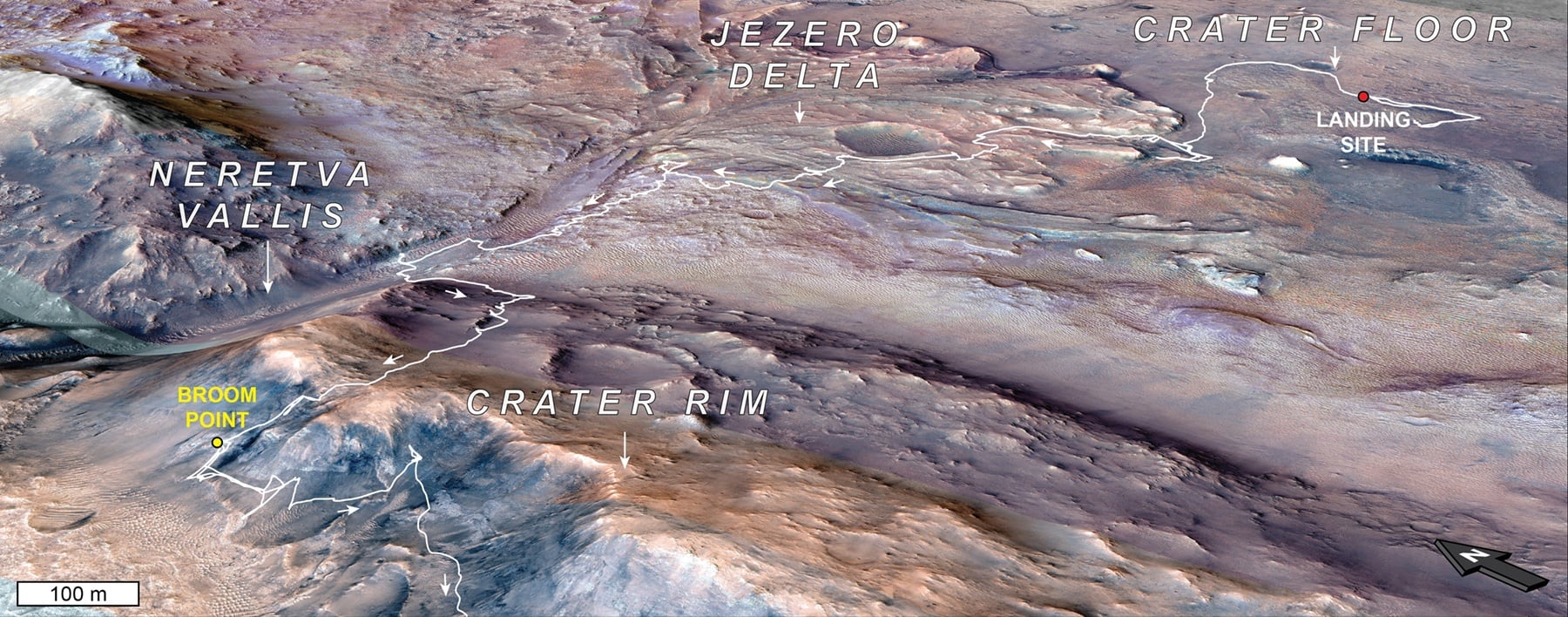 *This orbital map shows the path NASA’s Perseverance Mars rover took from its 2021 landing site in Jezero Crater to the “Broom Point” location in mid-2025. Credit: NASA/JPL-Caltech/MRO/HIRISE/UA/ICL*
The layered formation of the rock may also suggest interactions with water or ice, while some appear to have formed from rapid debris flows. On Earth, these flows can occur when molten rock comes into contact with water or ice, instantly transforming them into steam. The team theorizes that a massive asteroid impact and the presence of water or ice shaped the landscape billions of years ago. The impact came first and formed the 1,900-km (1,200-mi) wide Isidis Basin, one of the planet’s largest impact basins.
This was likely followed by a second asteroid impact that formed the Jezero Crater, fracturing and uplifting the already-tilted rocks into the formation found there today. Along with impact basins found elsewhere on Mars, the Moon, and Mercury, these craters and related features are helping scientists construct a timeline of the Solar System’s geological history.
Further Reading: NASA

