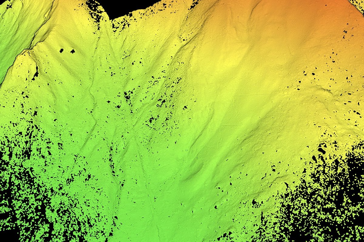
Лазерын технологийн тусламжтайгаар хийсэн шинжилгээгээр Перугийн Мачу-Пикчу орчмын бүс нутгаас 2.5 гаруй километр үргэлжлэх, урьд өмнө бүртгэгдээгүй эртний замууд болон газар тариалангийн байгууламжуудыг олж илрүүлжээ.
Судлаачид 2023 оны долоодугаар сард Мачу-Пикчугийн зүүн хэсэгт байрлах Мандор ханын бүсэд урьдчилсан судалгааны ажлыг эхлүүлсэн байна. Тус бүс нутгийн уулархаг, өтгөн ширэнгэн ой бүхий онцлог нь газрын гадарга дээрх археологийн олдворуудыг харагдахгүй болгодог тул мэргэжилтнүүд LiDAR буюу лазерын тусгал хэмжих дэвшилтэт технологийг ашиглажээ. Энэхүү технологи нь өтгөн ургамлын бүрхэвчийг нэвтлэн, газрын гадаргын нарийвчилсан загварыг гаргаж, хүний нүдээр ялгахад бэрх бүтэц, байгууламжийг илрүүлэх боломж олгодог.
Судалгааны явцад 1.2 километр үргэлжлэх тахирлан татсан зам илэрсэн нь хамгийн томоохон олдвор болов. Уг замын хийц нь инкүүдийн барилгын техниктэй төстэй шинж чанартай боловч түүнийг хэн, хэзээ барьсныг одоогоор тогтоогоогүй байна. Археологичид уг олдворыг хэзээ үүссэн болон ямар зориулалттай байсныг тодорхойлохын тулд газар дээр нь нэмэлт малтлага хийх шаардлагатай байгааг тэмдэглэжээ.
LiDAR-ын өгөгдлүүд нь 2.5 километрээс урт үргэлжлэх замуудаас гадна газар тариалангийн террас болон бусад тавцангуудыг илрүүлсэн нь тухайн бүс нутгийн түүхийг судлахад чухал ач холбогдолтой юм. Куско хотын албаны хүмүүс эдгээр олдворын насжилт, барилгын арга барил болон нөхцөл байдлыг судлах чиглэлээр нарийвчилсан ажил өрнүүлэхээр төлөвлөж байна. Энэхүү шинжлэх ухааны шинэ ололт нь Мачу-Пикчугийн эргэн тойрон дахь соёлын өвийг хамгаалах, цаашдын судалгааны чиглэлийг тодорхойлоход чухал суурь болох юм.
Дэлгэрэнгүйг эх сурвалжаас харах
↓Эх сурвалжийг нээх ↓
More than 2.5 kilometers of previously undocumented roads have been found beneath the thick forest around Machu Picchu. Laser scans picked up the hidden pre-Hispanic routes, including one stretching at least 1.2 kilometers, plus possible agricultural terraces and platforms.
The discovery comes from the Mandor wall area, east of Machu Picchu, where archaeologists carried out preliminary work in July 2023. Exploring this part of Peru is tricky, because the mountains are steep, the cloud forest is dense, and archaeological remains can disappear almost completely beneath the vegetation.
The team needed another way to see what was beneath the forest. Researchers used LiDAR to scan the landscape from above. The resulting images exposed features on the ground that were difficult to spot through the thick vegetation, including the hidden roads.
A Long, Zigzagging Road Was Sitting Under The Forest
The biggest find is hard to miss once the vegetation is digitally stripped away: a road running for at least 1.2 kilometers. The zigzagging route immediately caught researchers’ attention. Its design has features associated with Inca construction techniques, but that doesn’t prove who built it. Until archaeologists can determine its age, the road’s origins remain an open question.
More work on the ground is needed to find out when the road was built, what people used it for and how it connected with other structures around Machu Picchu. Heritage Daily also explained that the scans revealed much more than one hidden route. Across the area, researchers detected over 2.5 kilometers of previously undocumented pre-Hispanic roads. They also spotted possible agricultural terraces and platforms that will need further investigation.
LiDAR Can Spot What Is Almost Impossible To See On Foot
Dense vegetation makes this landscape particularly difficult to explore. Ancient roads can remain right on the surface yet become almost invisible beneath trees, plants and thick forest cover. LiDAR, short for Light Detection and Ranging, helps researchers see through that visual barrier and reveal details in the terrain that are difficult to spot from the ground.

The technology fires laser pulses toward the ground and measures the signals that bounce back. Researchers process that information to build detailed models of the terrain. Roads, terraces, foundations and other structures can then stand out even when they’re buried from view beneath vegetation. At Machu Picchu, that process revealed not only roads but also those possible terraces and platforms.
Why Were They Built?
The laser scans have given researchers a map of where to focus next. The next step is to investigate those features on the ground. Officials in Cusco have called for targeted archaeological studies to determine their age, construction methods, purpose and condition.
They will also look at how the remains can be protected and conserved, as well as how they might eventually be documented and presented within the wider Machu Picchu heritage landscape. Maritza Rosa Candia, executive director of the DDC Cusco, said new technology is expanding what specialists know about the territory surrounding Machu Picchu and helping them decide where future research and conservation work should focus.
Archaeologists have explored Machu Picchu for more than a century, and the site joined the UNESCO World Heritage List in 1983. Yet the surrounding forest was still hiding more than 2.5 kilometers of undocumented roads.
Enjoyed this article? Subscribe to our free newsletter for engaging stories, exclusive content, and the latest news.

