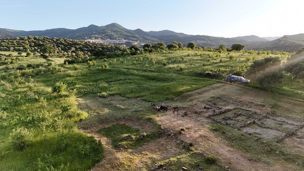
Геофизикийн дэвшилтэт аргуудыг ашиглан Италийн эрдэмтэд 2400 жилийн настай түүхэн дурсгалт газрын доорх нуугдмал байгууламжийг малтлага хийлгүйгээр олж илрүүлжээ.
Катаниягийн их сургуулийн судлаачид Калабриа мужийн Палуди хотын ойролцоох эртний сууринд судалгаа хийхдээ хөрсний давхаргыг хөндөхгүйгээр доорх бүтцийг тодорхойлох шинэлэг аргыг ашигласан байна. Энэхүү суурин нь МЭӨ IV зуунд байгуулагдсан бөгөөд Грекийн цагаачид эсвэл нутгийн Брутти овгийнхны аль нь үүсгэн байгуулсан нь одоог хүртэл тодорхойгүй байгаа эртний түүхэн дурсгалт газар юм.
Судлаачид өнгөрсөн тавдугаар сард цахилгаан эсэргүүцлийн томограф болон магнитометрийн аргыг хослуулан ашиглаж, газрын доорх давхаргыг рентген зураг мэтээр шинжилжээ. Цахилгаан гүйдэл дамжуулах чадвар болон соронзон орны өөрчлөлтийг хэмжсэнээр эрдэмтэд газрын гүнд нуугдсан чулуун байгууламж, хана хэрмийг илрүүлэх боломжтой болсон байна. GPS-д суурилсан нарийвчлалтай хэмжилтийн үр дүнд газар зүйн байршлын тодорхой зураглалыг гаргажээ.
Судалгааны үр дүнгээр 1-р бүсэд газрын гадаргаас 1.5-2 метрийн гүнд барилгын бүтэц байж болзошгүй тодорхой шинж тэмдгүүд илэрсэн байна. Ялангуяа суурингийн төв хэсэгт байрлах, үүрэг зориулалт нь тодорхойгүй барилгын үлдэгдэл нь тус бүс нутаг дахь шашны болон олон нийтийн үйл ажиллагааны чухал төв байсан байж магадгүй хэмээн судлаачид таамаглаж байна.
Энэхүү судалгааны арга нь түүхэн дурсгалт газрын бүрэн бүтэн байдлыг алдагдуулахгүйгээр ирээдүйн малтлагад зориулсан чухал мэдээллийг цуглуулах боломжийг бүрдүүлж байгаагаараа ач холбогдолтой юм. Хэдийгээр 2-р бүсэд ийм шинж тэмдэг илрээгүй ч 1-р бүсэд олж илрүүлсэн өгөгдөл нь эртний Хелленистик соёл Баруун Газар дундын тэнгист хэрхэн тархсаныг ойлгоход түлхэц болох юм.
Дэлгэрэнгүйг эх сурвалжаас харах
↓Эх сурвалжийг нээх ↓
Beneath the weathered stones of one of Calabria’s most important Hellenistic settlements, something long invisible has finally come into focus. Without lifting a single shovel of earth, a team from the University of Catania has detected buried structures beneath Castiglione di Paludi.
The site, perched above the modern town of Paludi in the province of Cosenza, has long been recognized for its imposing walls and carefully planned urban layout. Founded in the 4th century BC, it sits at a historical crossroads whose builders remain a matter of debate: was it raised by Greek settlers from Magna Graecia, or by the Bruttian peoples who inhabited the region? This has never been fully resolved, and the site’s monumental gates and orderly street grid only deepen the mystery of who exactly lived and governed there.
This is precisely why the discovery of this hidden structure matters. According to a press release published by The University of Catania, the research combined archaeological expertise with applied geophysics in a campaign designed to locate buried remains without disturbing the stratigraphy, a non-invasive approach that preserves the site for future, more precise excavation while still yielding real data about what lies beneath the surface.
A Fortified Structure Still Guarding Its Secrets
Castiglione di Paludi is no ordinary ruin. The structure defenses consist of a massive circuit wall, with access historically controlled through at least two gates in the eastern sector: the northeastern gate received especially monumental architectural treatment. Inside those walls, the settlement was organized around a central road axis, called the plateia, alongside at least one large space reserved for public functions.
As reported by University of Catania team, what has puzzled researchers most is a heavily deteriorated structure that interrupts the plateia almost exactly at its midpoint. Its function remains unclear, but its central position suggests it once served as another public hub, one that researchers believe may have carried significant sacred value.
Pinning down what this structure actually was could help situate Castiglione di Paludi within the broader, uneven process by which Hellenistic culture spread across the Western Mediterranean.
Reading the Ground Without Breaking It
Last May, archaeologists from the Department of Humanistic Sciences joined forces with geophysicists from the Department of Biological, Geological, and Environmental Sciences to scan what lies beneath the site, without digging into it. To do this, they used two complementary techniques that work a bit like an underground X-ray. The first, called Electrical Resistivity Tomography, sends a weak electrical current into the ground and measures how easily it passes through, since buried stone, walls, or debris tend to resist the current differently than plain soil.
The team ran eleven of these scans in each of the two survey zones, named Area 1 and Area 2, spacing them one meter apart to build a detailed picture of the subsurface. The second technique, magnetometry, measures tiny variations in the earth’s natural magnetic field, which can also reveal buried structures invisible to the naked eye. Every single measurement was precisely located using GPS-based positioning, allowing the researchers to map exactly where any unusual signals appeared underground.

On top of this, the team also ran a second type of scan, called a magnetometric survey, following the exact same grid on the ground. This method uses an instrument that detects tiny changes in the earth’s natural magnetic field, changes that can reveal buried structures invisible to the eye. It was set up in a specific mode, with its two sensors placed 2.30 meters apart, and it took 32 readings along each line, across 11 lines in every area studied. To make sure nothing was left to guesswork, every single measurement point, whether from this scan or the previous one, was precisely located using GPS, allowing researchers to map exactly where anomalies appeared and how the terrain itself varied across the site.
What the Data Revealed?
The results were far from uniform across the two zones. In Area 1, researchers identified clear anomalies at shallow depth, roughly between 1.5 and 2 meters, with resistivity values exceeding 90 ohms per meter, a signature consistent with buried construction remains. A 3D model built from the interpolated ERT sections showed these anomalies concentrated in the northeastern part of the surveyed zone, and magnetometric data from the same area revealed gradient anomalies that correlated well with the resistivity findings.
Area 2 told a different story. Its resistivity readings were comparatively regular, without pronounced anomalies near the surface, though some appeared at greater depth, potentially reflecting shifts in the substrate’s physical-mechanical properties. Consistent with this, the magnetic gradient data for Area 2 showed no significant variation.

As the University of Catania noted, the strong correlation between resistivity and magnetic results in Area 1 points to the likely presence of a buried structure, giving researchers a solid, non-invasive foundation for planning more detailed archaeological work, without having disturbed the ground the site has protected for over two thousand years.
Enjoyed this article? Subscribe to our free newsletter for engaging stories, exclusive content, and the latest news.

