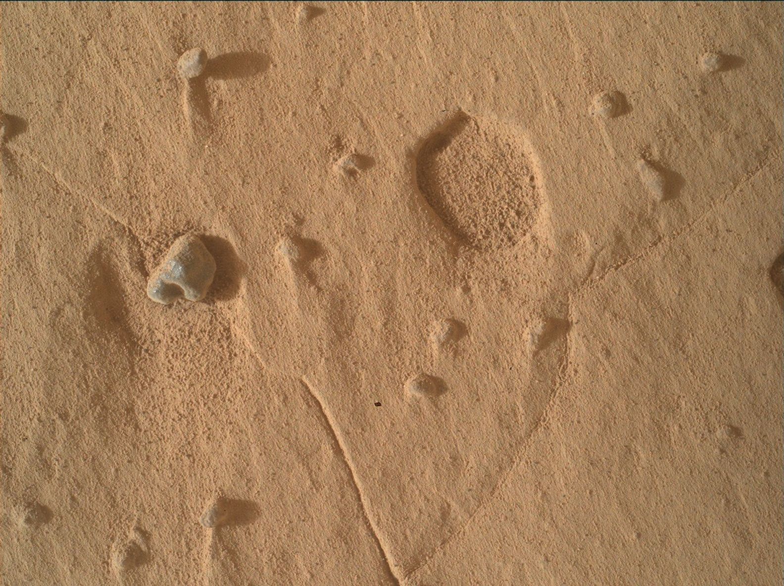
NASA-гийн Curiosity хөлөг Ангараг гарагийн Шарп уулын хөрсөн дээр нэг сантиметр орчим диаметртэй, ер бусын хэлбэрийн хонхорхойнуудыг олж илрүүлжээ.
Ангараг гараг дээрх чулуулагт хонхорхой, нүх үүсэх нь элбэг үзэгдэл бөгөөд ихэвчлэн хатуу чулуулаг эсвэл хайрга чулуу элэгдэлд орсны улмаас үүсдэг. Гэвч 2026 оны наймдугаар сарын сүүлээр илэрсэн эдгээр хонхорхой нь өмнө нь ажиглагдаж байсан нүхнүүдээс хамаагүй өргөн бөгөөд гүехэн хэлбэртэй байгаа нь эрдэмтдийн анхаарлыг татаж байна. Уг хонхорхойг үүсгэсэн бодитой зүйлс эргэн тойронд нь олдоогүй тул тэдгээрийн үүсэл одоогоор тодорхойгүй хэвээр байна.
Эрдэмтдийн баг MAHLI болон Mastcam багажуудыг ашиглан хонхорхойнуудын гурван хэмжээст бүтцийг нарийвчлан зураглаж, тэдгээрийн үүсэлтэй холбоотой байж болох химийн найрлагын шинжилгээг хийжээ. Мөн ChemCam багажаар дамжуулан уг талбайд тархсан саарал өнгийн чулуунуудыг шинжилж, тэдгээр нь хонхорхой үүсэхэд нөлөөлсөн эсэхийг тодруулахаар ажиллаж байна. Шарп уулын давхаргат бүтэц нь тухайн бүс нутагт явагдсан эртний тунамал хуримтлалын үйл явцын талаарх чухал мэдээллийг агуулж байж болзошгүй юм.
Судлаачид уг хонхорхойнуудыг судлахтай зэрэгцэн бүс нутгийн хэмжээний тоосны шуурганы төлөв байдлыг REMS цаг уурын станцаар дамжуулан хянаж байна. Одоогийн байдлаар эрдэмтэд цуглуулсан өгөгдлүүдэд үндэслэн тухайн хонхорхойнуудыг яг юу, хэзээ үүсгэснийг тогтоохоор судалгааны ажлаа үргэлжлүүлж байна.
Дэлгэрэнгүйг эх сурвалжаас харах
↓Эх сурвалжийг нээх ↓
Fourteen years into its mission, the Curiosity rover is still finding features that leave its science team without a ready explanation.
During a week of work on Mount Sharp in late August 2026, the team came across broad, shallow pits scattered across the bedrock, roughly a centimeter in diameter, unlike anything the mission has documented before. “Both of our workspaces this week contained features unlike quite anything we have seen in the past,” wrote Michelle Minitti, deputy principal investigator for Curiosity’s Mars Hand Lens Imager (MAHLI), in a mission update published September 3.
The pits themselves aren’t unusual. Voids in Martian bedrock are common.
When resistant nodules or pebbles weather out of their host rock, they leave a void behind, a process the mission has come to understand well after years of surface observation. Here, though, the geometry was off: the pits were much broader and shallower than earlier examples. Nor were there obvious objects that had once occupied them. Whatever formed the depressions left nothing behind to identify itself.
Mapping an Unknown Structure
First came the geometry.
MAHLI and Mastcam acquired stereo mosaics and overlapping image sets for construction of digital elevation models, giving the team a way to resolve the pits’ three-dimensional structure. If the depressions share a consistent depth-to-width ratio, that could point toward a single formation process; if their shapes vary substantially, one tidy explanation becomes harder to sustain.
Around the pits, the bedrock complicated matters further. Mastcam imaged and ChemCam rastered across complex packages of layers where texture and structure changed over short vertical distances, possibly preserving shifts in depositional conditions almost on top of one another.
Within those packages sat gray, rough, resistant layers that stood apart from the host bedrock and likely reflected a different chemistry. ChemCam, MAHLI, and the APXS (Alpha Particle X-Ray Spectrometer) all examined those units. ChemCam also targeted small, loose gray float rocks scattered unevenly across the workspaces. The question was where those stones came from.
Buttes on the Horizon
Farther out, the butte nicknamed “Cordillera” got a comprehensive Mastcam mosaic covering its entire visible face, while ChemCam collected high-resolution Remote Micro-Imager mosaics aimed at particular horizons.
Two more buttes farther south down “Valle Grande,” “Tolhuaca” and “Potosí,” also drew scrutiny. ChemCam assessed potential cross-bedding there and examined dark capping material on Potosí for mineralogical information.
Cross-bedding is the angling of sediment layers away from the horizontal. It can record ancient water or wind currents that deposited the rock. Finding it, or failing to, in Potosí’s face carries information about the conditions that built this part of Mount Sharp. Potosí.
Watching the Sky
At the same time, Curiosity’s environmental science team planned REMS, Mastcam, and Navcam activities at a higher-than-usual cadence to watch a potential regional dust storm.
REMS is the rover’s weather station, measuring temperature, pressure, humidity, and wind. By the end of the week, the storm appeared to be fading.
All of it was accomplished despite losing one planning day to a failed downlink.
The pits are still unexplained. The team now has precise elevation models of their shape, compositional readings from the chemically distinct layers within them, and data on the gray float rocks that may or may not have anything to do with the depressions. What carved them, and when, remains unresolved.
Enjoyed this article? Subscribe to our free newsletter for engaging stories, exclusive content, and the latest news.

