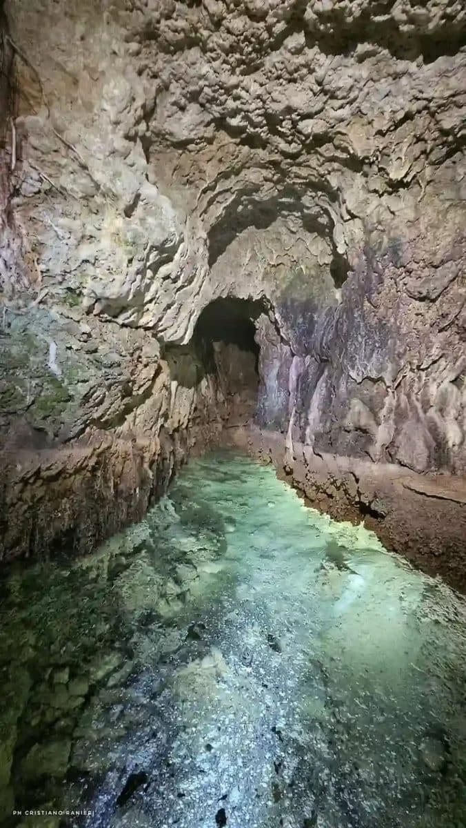
Судлаачид Ромчуудын усны байгууламжийн технологийн үндэс нь эртний Сабины иргэншлийн инженерчлэлтэй холбоотой байж болзошгүйг тогтоов.
Ром хотоос зүүн хойд зүгт орших Монтелеоне Сабино хотын ойролцоо агуй судлаачид болон археологичид 100 орчим метр үргэлжлэх эртний газар доорх усан сувгийг олж илрүүлэн зураглажээ. Gruppo Speleo Archeologico Vespertilio байгууллагын судлаачид Ром болон Риети мужийн Археологи, соёл урлагийн газрын удирдлага дор уг байгууламжийг судалсан байна. Уг суваг нь 2-5 сая жилийн өмнөх геологийн давхаргад ухагдсан бөгөөд готик сүмүүдийн цонхтой төстэй “огивал” буюу үзүүрлэг хэлбэртэй хөндлөн огтлолтой юм.
Энэхүү суваг нь тус бүс нутагт өмнө нь бүртгэгдсэн Ромын үеийн болон бусад эртний усны байгууламжуудаас ялгаатай, өмнө нь баримтжуулагдаагүй дөрөв дэх дэд бүтэц болох нь тогтоогджээ. Судалгааны багаас тэмдэглэснээр, уг сувгийг барихдаа үндсэн шугамыг ухахаас өмнө босоо чиглэлтэй туслах нүхнүүдийг тогтмол зайтайгаар гаргаж, тэдгээрийг холбох аргыг ашигласан байна. Энэхүү технологи нь хожим Ромчуудын өргөнөөр ашигласан усан суваг барих аргачлалтай ижил төстэй байгаа нь уг мэдлэгийг Ромчууд өвлөн авч, улам боловсронгуй болгосон байж болохыг илтгэж байна.
Археологичдын үзэж байгаагаар, ийм хэмжээний томоохон байгууламжийг бүтээхэд төлөвлөгөөт удирдлага, нөөцийн зохион байгуулалттай хуваарилалт шаардлагатай байсан нь Сабины нийгэм Ромын нөлөөнөөс өмнө өндөр түвшний зохион байгуулалттай байсныг гэрчилж байна. Энэхүү олдвор нь тухайн бүс нутагт эртний иргэншил хэрхэн хөгжиж байсныг харуулах чухал баримт болж байна.
Одоогийн байдлаар судалгааны баг сувгийн эхлэл болон төгсгөлийн цэгийг хараахан тогтоогоогүй байгаа бөгөөд цаашид хөрсний шинжилгээ болон чулуун дээрх багажийн мөрөөр дамжуулан он цагийг нарийвчлан тогтоох шаардлагатай байна. Одоогоор газрын зураглал хийсэн 100 метр хэсэг нь Сабины толгод дор нуугдсан илүү том усан хангамжийн сүлжээний нэгээхэн хэсэг байх магадлалтай гэж судлаачид таамаглаж байна.
Дэлгэрэнгүйг эх сурвалжаас харах
↓Эх сурвалжийг нээх ↓
A team of cavers and archaeologists has mapped roughly 100 meters of an underground water tunnel cut into a hillside northeast of Rome, revealing a pre-Roman aqueduct built by the ancient Sabine people. The find, made near the small town of Monteleone Sabino, shows that centuries before Roman engineers became famous for their hydraulic works, local populations were already using strikingly similar techniques to move water through solid rock.
The discovery adds a new layer to what was already known about Sabina, a region that Rome would eventually absorb but that had its own political and technical sophistication long beforehand. Archaeologists say the tunnel is an evidence that organized, centrally directed labor was shaping this landscape well before Roman armies ever arrived.
A Tunnel Cut Through Millions of Years of Rock
The passage explored by the Gruppo Speleo Archeologico Vespertilio, working under the scientific direction of the Soprintendenza Archeologia, Belle Arti e Paesaggio for Rome and Rieti province, runs about 328 feet through alternating bands of conglomerate and clay-marl rock, geological layers laid down between two and five million years ago. The channel has a distinctive pointed, or “ogival,” cross-section, the same shape later echoed in Gothic cathedral windows, though here it served a purely functional purpose.
According to the Soprintendenza, this structure is entirely distinct from other underground works already known in the town, including the Roman-era cuniculi tied to the amphitheater and baths at nearby Trebula Mutusca, and the separate pre-Roman hydraulic system documented since 1997 beneath the Church of Santa Vittoria.
As reported by the statement, this is a fourth, previously undocumented piece of underground infrastructure in an area that is turning out to be far more extensively engineered than researchers had assumed.
A Construction Method Rome Would Later Adopt
What most struck the survey team was how the tunnel was built. Workers first sank a series of transverse shafts and side-galleries, narrow vertical cuts perpendicular to the main line, spaced at regular intervals, and only afterward excavated the main tunnel in a straight run, connecting each shaft along the way.
It’s essentially the same method Roman engineers would later use for their own water tunnels, adapted here to the local terrain generations before Rome had any foothold in the region. The find suggests the technique wasn’t a Roman invention so much as one they inherited, refined, and scaled up.
Evidence of a Centralized Sabine Authority
Beyond the engineering itself, researchers point to what the project implies about Sabine society. A structure of this scale, requiring advance planning, a coordinated sequence of excavation, and a sustained investment of labor, isn’t something a loosely scattered population puts together.
The Soprintendenza has framed it as evidence of a centralized authority capable of mobilizing technical and human resources over time, fitting into a broader picture of small rural settlements, or vici, linked by road to the Apennine interior and the Tiber valley, all falling under what researchers call the pagus of the Mutuesci, a rural district with its own organizational capacity, long before Rome existed as a regional power.

The team still has plenty of ground to cover, they have yet to locate the tunnel’s intake and outflow points, trace its full course beyond the stretch already walked, or establish a precise chronology through sediment analysis and tool marks in the rock.
For now, the hundred meters already mapped stand as one confirmed piece of what researchers suspect is a considerably larger, still-buried hydraulic network beneath the Sabine hills.
Enjoyed this article? Subscribe to our free newsletter for engaging stories, exclusive content, and the latest news.

