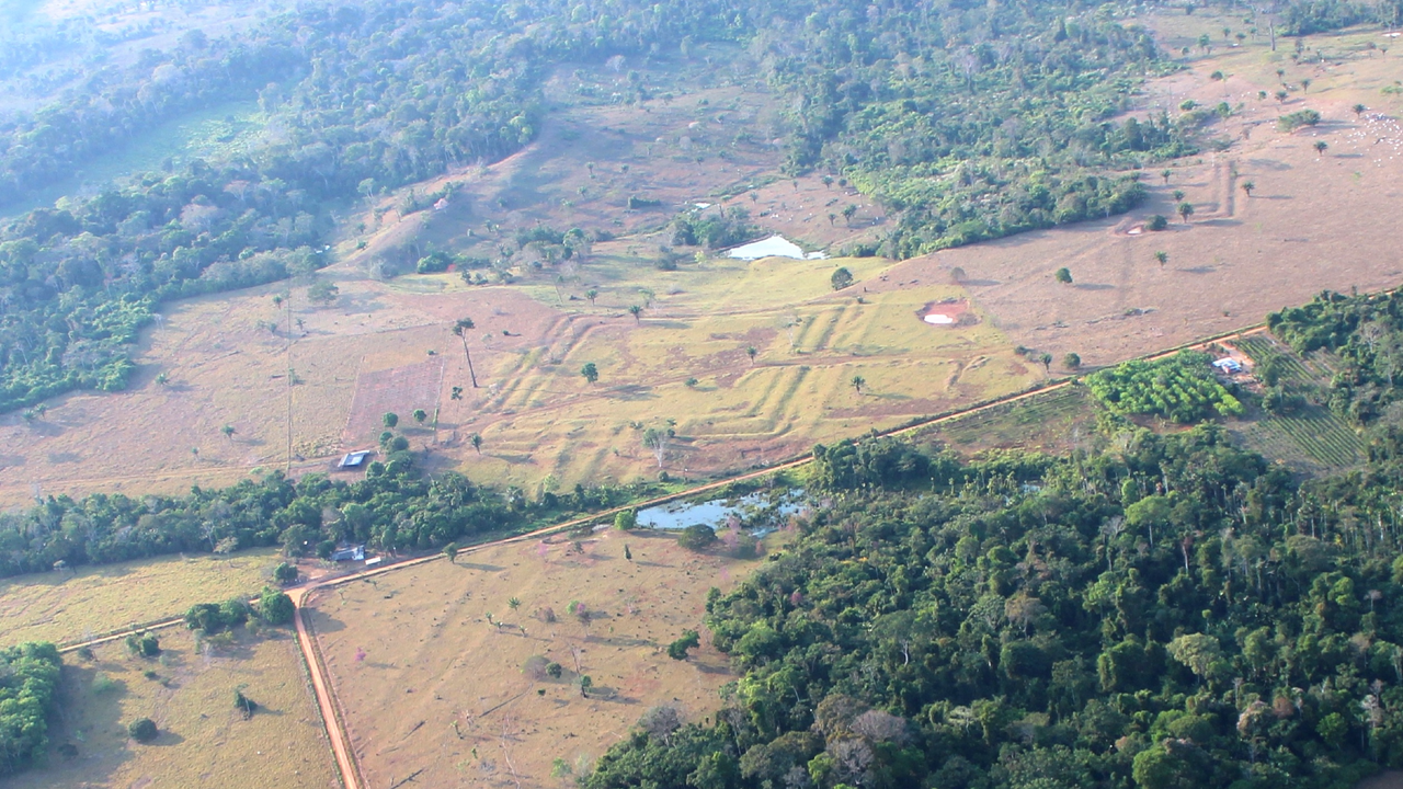
Лазер сканнердах технологийн тусламжтайгаар Амазоны ширэнгэн ойн өтгөн ургамлын доороос 2500 жилийн тэртээх “Акури” хэмээх нууцлаг соёл иргэншлийн үлдэгдлийг археологичид олж илрүүллээ.
Хельсинкийн их сургуулийн археологич Марти Парссениний удирдсан судалгааны баг Амазоны 4500 хавтгай дөрвөлжин километр талбайд лазерын (lidar) судалгаа хийж, 396 шинэ геоглиф буюу газрын гадаргуу дээрх геометрийн дүрс бүхий байгууламжийг илрүүлжээ. Эдгээр байгууламж нь гүн шуудуу, өндөр далангаас бүрдэх бөгөөд МЭӨ 600-аас МЭ 850 оны хооронд баригдсан байна. Археологичдын үзэж буйгаар тухайн үед Акури соёл иргэншил нь 1.25 саяас 3 сая хүртэлх хүн амтай байсан байж болзошгүй аж.
Судалгаагаар тус иргэншлийн хүмүүс эдгээр геометрийн байгууламжийг тойруулан олон айл өрх бүхий суурин үүсгэж, эрдэнэ шиш, хулуу зэрэг таримал ургамлыг тариалдаг байсныг тогтоожээ. Мөн эдгээр төв нь олон нийтийн цугларалт, улс төрийн шийдвэр гаргах болон орон нутгийн иргэдийн хоорондын харилцааг бэхжүүлэх зан үйлийн зориулалттай байсан гэж үзэж байна.
Одоогийн байдлаар бүс нутгаас 1700 орчим геоглиф олдоод байгаа ч цаашид 20,000 гаруй байгууламж илрэх магадлалтай гэж судлаачид таамаглаж байна. Гэвч Акури соёл иргэншил яагаад МЭ 850-950 оны үед гэнэт мөхсөн нь одоогоор тодорхойгүй байгаа бөгөөд энэ нь тухайн үеийн Майя болон Андын нурууны Тиванаку, Вари соёл иргэншлийн уналттай холбоотой байж болох талтай юм.
Дэлгэрэнгүйг эх сурвалжаас харах
↓Эх сурвалжийг нээх ↓
Using laser scanning technology to peer beneath the dense canopy of the Amazon rainforest, archaeologists have discovered hundreds of ancient earthworks that were made by a complex, enigmatic society over two millennia ago, a new study finds.
This ancient civilization, called the Aquiry, arose 2,500 years ago in Brazil. Based on the large number of earthworks, called geoglyphs, the Aquiry may have had 3 million people before the society collapsed, the researchers suggested in the study.
“The cultures and societies that composed the Aquiry shared a common worldview and constructed ceremonial centers in a variety of monumental geometric forms, characterized by deep ditches and high outer embankments, commonly known as Amazonian geoglyphs,” Martti Pärssinen, an archaeologist at the University of Helsinki, told Live Science in an email.
In the new study, published Wednesday (July 29) in the journal Nature, Pärssinen and co-authors presented findings from their survey of nearly 1,740 square miles (4,500 square kilometers) of Amazonian rainforest, which revealed 396 new geoglyphs and allowed them to approximate the geographical extent of the Aquiry civilization.
Pärssinen has been investigating geometric earthworks in Brazil’s Acre state for more than two decades. In a 2021 study, he officially introduced the name Aquiry for the multicultural ancient civilization, named after the Acre River, which flows from Peru and Bolivia through the present-day states of Acre and Amazonas in Brazil. Aquiry means “river of caimans” in the language spoken by the Indigenous Arawakan people.
Because of the dense canopy of trees in the rainforest, archaeological investigation in the area has been limited. Most of the evidence for the Aquiry civilization comes from lidar and airborne laser scanning of monumental geoglyphs that were constructed between 600 B.C. and A.D. 850, according to the study. People lived in multifamily longhouses around the earthworks, and they farmed crops like maize and squash.
“According to native oral traditions, the Aquiry centers were built to foster relations among communities” and with significant otherworldly beings, Pärssinen said. These centers also served as venues for gatherings and political decision-making, and they enabled chiefs to display their generosity, he added.
To date, archaeologists have identified around 1,700 known geoglyphs in the area. But the researchers think the total is significantly higher, with more than 20,000 Aquiry earthworks waiting to be found in places that haven’t yet been surveyed. And based on an estimate of 300 people needed to build and maintain each geoglyph on average, the researchers estimated that the Aquiry civilization likely peaked at 1.25 million to 3 million people between A.D. 100 and 300.
Similar geoglyphs dating to between 200 B.C. and A.D. 500 have been found in Peru. Known as the Nazca Lines, these earthworks are shaped like animals, humans, plants and fantastical figures, in addition to having geometric motifs. The Nazca were an interconnected regional society of precolonial farmers who were able to survive in a forbidding geographic region, but they lived roughly 1,050 miles (1,700 kilometers) from the Aquiry.
“The Nazca geoglyphs represent a different phenomenon and were probably unrelated to the Aquiry civilization,” Pärssinen said. “Nevertheless, in both cases, the straight roads and lines, as well as the geometric forms and motifs, are best appreciated from the air.”
The presence of thousands of geoglyphs in the southwest Amazon region is leading archaeologists to rethink assumptions about precolonial civilizations and urban development — but it’s also bringing up questions about the fate of the Aquiry.
“We do not know why the geoglyphs were suddenly abandoned between A.D. 850 and 950,” Pärssinen said. “The available evidence points to a relatively rapid collapse” that may be related to the disappearance of other major precolonial powers, he said, “including the Classic Maya in Central America and the Tiwanaku and Wari civilizations in the Andes.”
How much do you know about the first people to reach the Americas? Find out with our First Americans quiz!

